

Winter Storm Approaching North Jersey
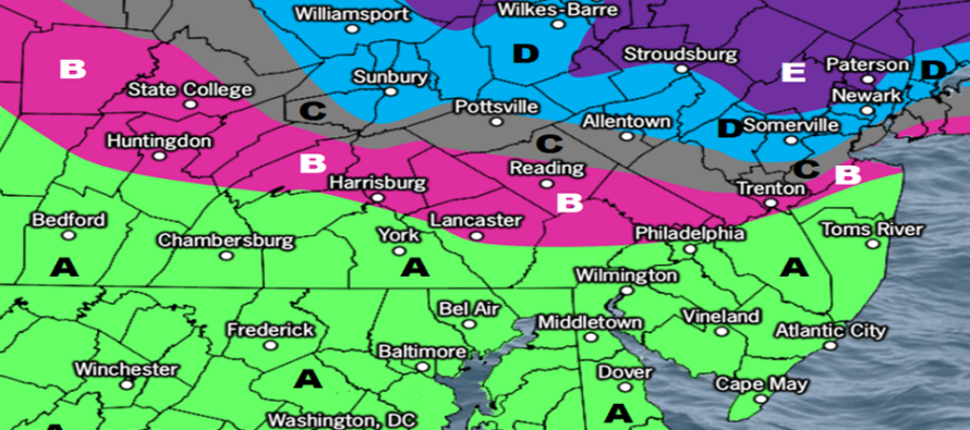
Discussion: The wintriest snowstorm of the season is approaching NNJ. This isn’t saying much this season but here we are. I don’t see this being a Kaboomable event. I think maybe some spots in NNJ have a chance of double digits, but a foot will be very challenging to meet given the duration and temp profile of the event. The jackpot (zone E) should be more in the 5-8 range with again maybe a few lollipops higher.
The best snows should generally hit the I-80 and northward region but could possibly push down towards the I-78 region. This will all depend on the extent of shallow warm layer intrusion at the ~850mb layer. A shallow ~850mb warm layer could convert some of that snow between I-78 and I-80 to sleet. Additionally, marginal surface temperatures (32 or just above) could push N as far as I-80 which could additionally stunt accumulations anywhere S of such. For this reasoning, we have this area mostly in zone D.
Moving further southward in NJ, zones C and B still have a reasonable chance for wintry accumulation but will battle warm layer mixing and marginal surface temps (32-40) the most out of areas expected to accumulate. Slush snow on natural surfaces the most likely outcome. For this reason we have a general expectation of 3 inches along I-78 in general fading out to nothing by the time you reach I-195.
Zone A is expected to be mostly rain. Areas closer to I-195 could mix but little to no snow or ice accumulation is expected. Just wet and raw (low-40s rainfall). Zone A’s greatest impact will be onshore winds along the ECNJ/SENJ coasts. It’s looking like sustained winds of 15-25mph with gusts to 40mph or so (run-of-mill stormy coast). Should start ramping up later tonight and flex after midnight into mid-to-late Tuesday morning. Only a minor coastal flooding concern after midnight tonight.

Click here to see full-resolution snow map!
Timing: There’s already a band of precip that has pushed into parts of WNJ, mainly SWNJ. Precip should continue to push across NJ from W to E and fill in the rest of the state by later this evening. Most precipitation falls overnight and wraps up by daybreak tomorrow morning. Wintry precip could hang on later into tomorrow (along and N of I-80). Winds flex between later tonight and noon tomorrow.
The Friday-Saturday system is still there however has trended warmer. The NNJ/CNJ/SNJ snow/ice/rain idea might also apply rather than more of a statewide snowstorm. I still want to wait until this system is out of here tomorrow before focusing on the weekend storm system.
In English: Snow, sleet, and rain are approaching/into NJ from the W and should fill in the rest of the state by later this evening. Precipitation should fall this evening through tomorrow morning, possibly later for N areas. The general concept is Snow for NNJ, snow and ice for CNJ, and rain for SNJ. Please see our impact map above. Stronger winds should stay along ECNJ/SENJ coast with a minor threat of coastal flooding just after midnight tonight. Lesser winds away from the ocean. Radar/observation updates will begin in a few hours. Have a great rest of your Monday and please be safe! JC
Premium Services
KABOOM Club offers inside info forecast discussion, your questions answered, and early storm impact maps (ahead of the public). At 99 cents per month, it’s an extremely feasible way to show support.
My Pocket Meteorologist (MPM), in partnership with EPAWA Weather Consulting, offers professional/commercial interests, whose businesses depend on outdoor weather conditions (snow plowing, landscaping, construction, etc.), with hyper-local text message alerts/forecasts and access to the MPM premium forum—the most comprehensive and technical forecast discussion available for PA and NJ.
Jonathan Carr (JC) is the founder and sole operator of Weather NJ, New Jersey’s largest independent weather reporting agency. Since 2010, Jonathan has provided weather safety discussion and forecasting services for New Jersey and surrounding areas through the web and social media. Originally branded as Severe NJ Weather (before 2014), Weather NJ is proud to bring you accurate and responsible forecast discussion ahead of high-stakes weather scenarios that impact this great garden state of ours. All Weather. All New Jersey.™ Be safe! JC


LOCAL FORECAST | INTERACTIVE RADAR | LATEST NJ WEATHER ALERTS | WEDDING FORECAST| PRIVACY POLICY
© Copyright 2026 Weather NJ LLC. All Rights Reserved.
Some information that can be found on our website is provided by a private weather station and is not an officially recognized station for weather reporting. Though we always strive to achieve accurate reporting for our own use, it is important that you do NOT depend on the data provided here for any purpose.
