

Winter Storm Approaching Southern and Central New Jersey
Discussion: To review, our mild and rainy period is coming to an end today/tonight. The low-pressure series that brought us our rain these last few days is pulling away and will drop temperatures overnight tonight with back-side cyclonic flow out of the N. That’s how we are going to go from unseasonably mild right now to “cold enough for snow” by daybreak tomorrow.
The departing low will also set up the boundary to the S of NJ (the highway for the snow storm to ride/track). It looks like the low of interest will now eject into the Atlantic Ocean over N OBX and track towards the 40N/70W benchmark between midnight tonight and Monday night. The low is now modeled stronger with a 996mb and dropping center as it ejects Monday morning and deepens further later Monday.
Why is it modeled stronger? Because there is a stronger wrap up of cyclonic vorticity associated with the upper-level low over the interior SE US. This creates an area of divergence and difluence in the atmosphere over the surface low (commonly found in the best area of Positive Vorticity Advection (PVA)). These forces expand the upper-atmosphere and basically vacuum the Coriolis-gathering surface air upwards towards it. The cyclonic gathering at the surface then intensifies and the surface low pressure center drops. This is what is going on which explains the recent ramp up in suggested storm intensity. Also for these reasons, SENJ coastal areas should expect some increased, possibly gusty, winds out of the NW Monday morning.
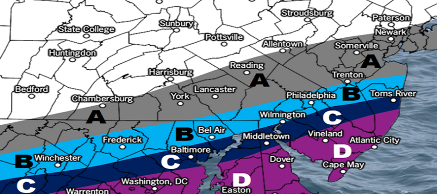
This is still a SNJ jackpot storm though. The suppressive/subsident forces that will provide the temperature drop and flat storm track meteorologically mean very dry air to the N of the snow band. This is why the ABE PA area through NNJ are likely looking at a sharp cut-off of precipitation. CNJ is looking at a little more snow now but SNJ, especially SENJ, is eyeing the jackpot (most snow accumulation of the system). This area should have the best frontogenic forcing over it with temperatures cold enough for snow to fall and accumulate at all layers.
Timing has not changed. This has always been a early Monday AM through Monday afternoon storm system. There might be a little bit of rain that falls overnight tonight before it changes to snow by sunrise Monday. Therefore, the transition from mild to cold enough should happen between about midnight tonight and 6am Monday morning. Just enough to wash away the brine (smacks forehead) before the changeover. Be careful out there as the initial rain could freeze under the snow and create some prematurely-icy spots.
The January 7 signal (this coming Friday) is still alive and is actually targeting the other side of the I-95/NJTP corridor (bringing snow to NNJ/CNJ. Let’s get this system out of the way before addressing that one in detail.
So these are our expected amounts between Monday morning (in time to disrupt commuting and school) and Monday afternoon/evening:
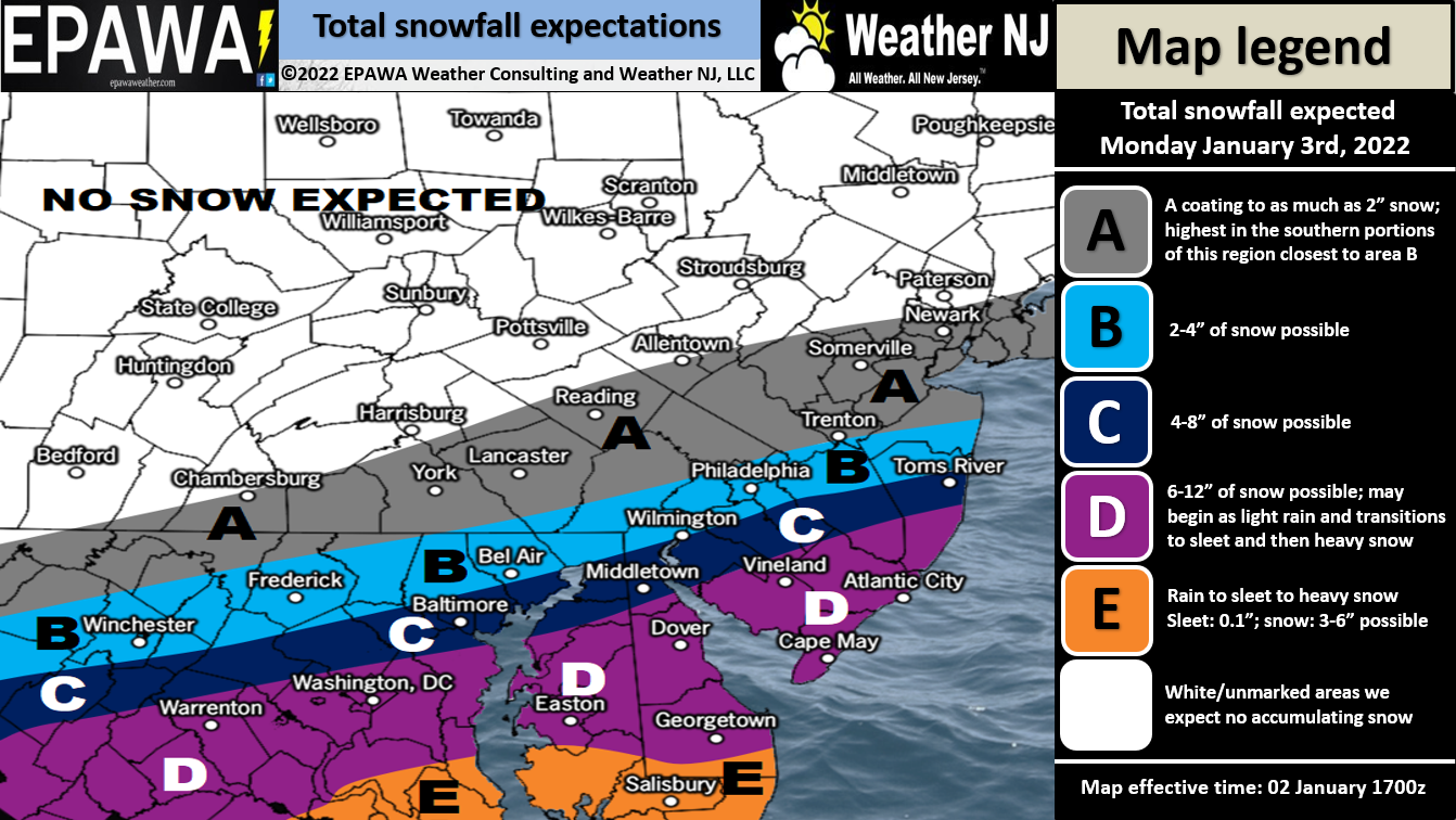
In English: I’d be surprised if there aren’t winter storm warnings issued by the NWS soon for SNJ tomorrow…at least for Cape May, Cumberland, Atlantic and S Ocean Counties. The criteria seems met IMO. SNJ, especially SENJ, should expect a significant snowfall between Monday morning and late-Monday afternoon. Major is not off the table. CNJ should get in on a nice little accumulation with NNJ likely left hanging with the lowest amounts if any. Please see the above map for details. Just remember that it might start as rain overnight tonight but will change to snow with possibly some sleet between (during the transition). When the sleet pellets silence, you’ll know you are over to snow. SENJ coastal areas should expect some NW winds to pick up Monday morning-afternoon but coastal flooding shouldn’t be too bad. Otherwise, the K-word is on standby should any area in SNJ look like it’s heading to 12 inches+. We should then stay cold Monday night/Tuesday leading into the next wintry storm signal on Friday (Jan 7) which is currently targeting NNJ. Everyone please have a great rest of your Sunday and be safe! JC
Download the free Weather NJ mobile app on Apple or Android. It’s the easiest way to never miss Weather NJ content. Our premium services go even further above and beyond at the hyper-local level.
Jonathan Carr (JC) is the founder and sole operator of Weather NJ, New Jersey’s largest independent weather reporting agency. Since 2010, Jonathan has provided weather safety discussion and forecasting services for New Jersey and surrounding areas through the web and social media. Originally branded as Severe NJ Weather (before 2014), Weather NJ is proud to bring you accurate and responsible forecast discussion ahead of high-stakes weather scenarios that impact this great garden state of ours. All Weather. All New Jersey.™ Be safe! JC


LOCAL FORECAST | INTERACTIVE RADAR | LATEST NJ WEATHER ALERTS | WEDDING FORECAST| PRIVACY POLICY
© Copyright 2026 Weather NJ LLC. All Rights Reserved.
Some information that can be found on our website is provided by a private weather station and is not an officially recognized station for weather reporting. Though we always strive to achieve accurate reporting for our own use, it is important that you do NOT depend on the data provided here for any purpose.
