

Winter Storm Approaching
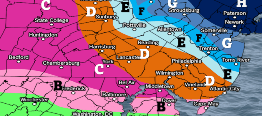
Discussion: I wish this was an all-snow event, or even a typical snow/rain event with a well-understood baroclinic boundary. It would be much easier to create the final wintry impact map. But it’s not. This is a very difficult battleground zone forecast to nail for some of the highest populated areas of NJ. NNJ/NENJ is easier because of the all-snow expectation. SNJ/SWNJ is easier because of warmer mostly ice expectation. But everyone between is extremely difficult to pinpoint the exact wintry precipitation types (snow vs sleet vs freezing rain).
It will be cold enough at all layers to support some form of wintry precipitation. And precipitation should be heavy at times. For those reasons it is very much a winter storm for all of NJ. It’s just only a snowstorm for NNJ. Our thermal gradient that will be running NW to SE will have a much wider than normal zone of warm layer influence. The warm layer will be thinnest up near I-80/I-78. It will be thickest across SNJ. But it should play a role in deteriorating snowflakes into some form of sleet pellet for much of the lower-2/3 of NJ.
Sussex, Passaic, Bergen, most of Morris and Essex, this is a snowstorm for you with the highest amount of snow accumulations expected. Warren down through N Monmouth Counties (again running NW to SE) are looking at a significant snowfall before changing over to sleet. Hunterdon down through N Ocean County is looking at a light snow accumulation before changing over to sleet for most of the event. Everyone S of that is looking at very little snow, if any, before changing over to all sleet. Lastly, Cape May County and S Cumberland is the only areas we believe could change over to plain rain after starting as sleet. Some of you across CNJ and northern SNJ might see an inch of sleet accumulate.
I’m not going to sugar coat it. Our map looks like Picasso took too much of something illegal before throwing together a painting during sunrise. However, we wish to put our best message out there to separate all zones by specific ice expectations. Again, all snow is all snow. It’s easy. But ice is a different animal, especially heavy rates of ice. It’s not the preferred wintry precipitation type of the winter storm lover but it’s extremely hazardous for travel. That said, this is our final call heading into this system and I will try my best to simplify in layman’s terms in the In English section.
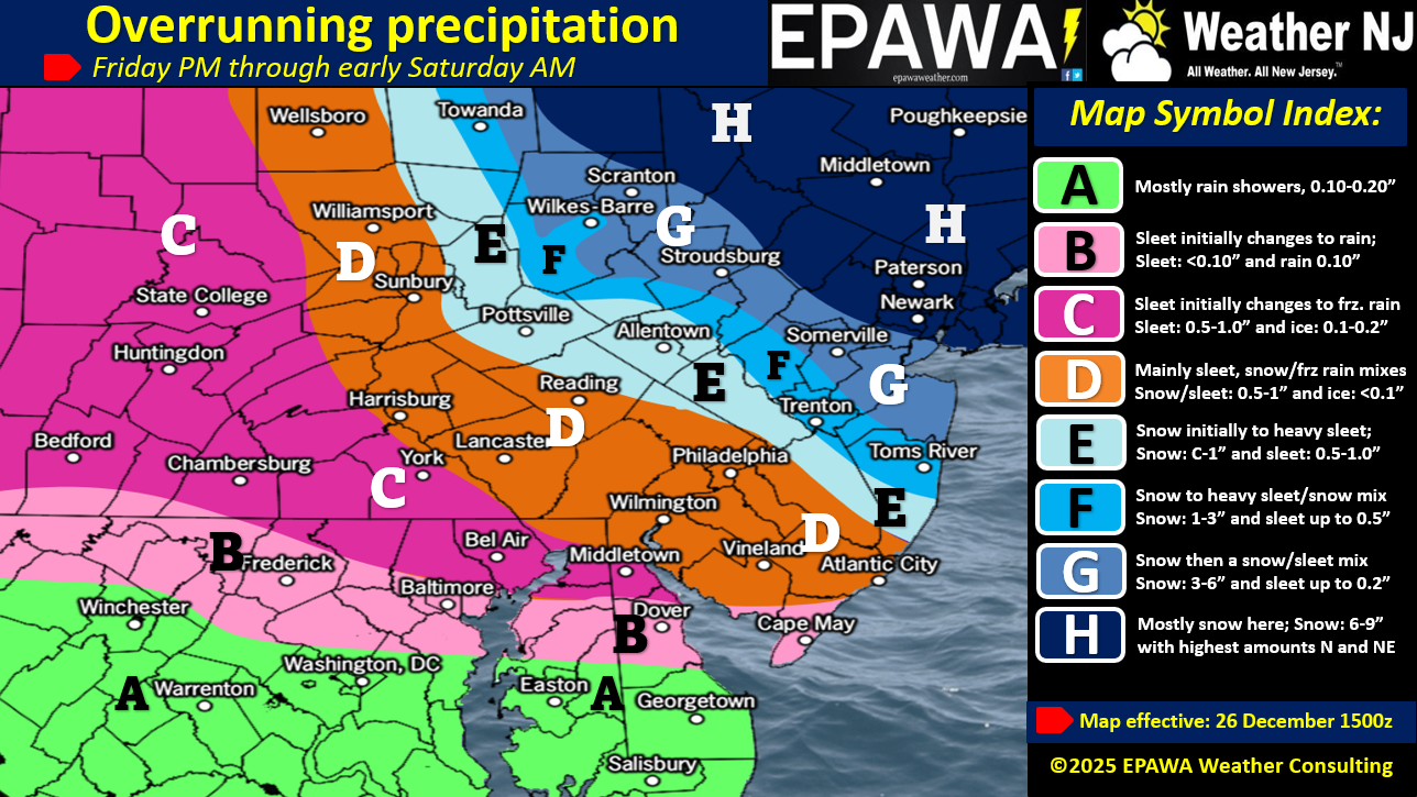
In English: Timing for this event is still a general 5pm today to 5am tomorrow morning expectation with the heaviest rates of precipitation likely occurring between 7pm and 3am. There is some initial stuff moving in that could fall well ahead of this window however the steadier stuff is the general window. I’ve been telling everyone I know to be inside by 3pm today just to play it safe. It’s a snowstorm for NNJ. It’s a snow to ice storm for CNJ, It’s mostly an ice storm for SNJ. And when I say ice storm, we are expecting mostly sleet (snow that melts aloft and refreezes into an ice pellet at lower elevations before hitting the ground – capable of accumulating like snow). This is beneficial for power outages as sleet does not accumulate much on tree branches and power lines…so there’s that! Because most layers are cold, we see less freezing rain (hits ground as a wet raindrop and then freezes on the ground) or plain rain with this system outside of extreme SNJ. Our map above is our best effort to convey what’s possible. I might throw together a YouTube video later this afternoon/evening to kick off live observations. Have a great rest of your Friday and please be safe! JC
Premium Services
KABOOM Club offers an ad-free environment, inside info (Above and Beyond) forecast discussion, your questions prioritized, and early storm impact maps and video releases (ahead of the public). At $1.99 per month, it’s an extremely feasible way to show additional support for Weather NJ and you can turn it on and off for however many months you wish. Think of it as a tip jar with perks. Available on Facebook or Patreon.
My Pocket Meteorologist (MPM), in partnership with EPAWA Weather Consulting, offers professional/commercial interests, whose businesses depend on outdoor weather conditions (snow plowing, landscaping, construction, etc.), with hyper-local text message alerts/forecasts from real meteorologists and access to the MPM premium forum—the most comprehensive and technical forecast discussion available for PA and NJ commercial interests.
KABOOM Shop is live if you want some KABOOM or Weather NJ Merch!
Sign up for ZoneWatch Radar and get 10% off
Jonathan Carr (JC) is the founder and sole operator of Weather NJ, New Jersey’s largest independent weather reporting agency. Since 2010, Jonathan has provided weather safety discussion and forecasting services for New Jersey and surrounding areas through the web and social media. Originally branded as Severe NJ Weather (before 2014), Weather NJ is proud to bring you accurate and responsible forecast discussion ahead of high-stakes weather scenarios that impact this great garden state of ours. All Weather. All New Jersey.™ Be safe! JC


LOCAL FORECAST | INTERACTIVE RADAR | LATEST NJ WEATHER ALERTS | WEDDING FORECAST| PRIVACY POLICY
© Copyright 2026 Weather NJ LLC. All Rights Reserved.
Some information that can be found on our website is provided by a private weather station and is not an officially recognized station for weather reporting. Though we always strive to achieve accurate reporting for our own use, it is important that you do NOT depend on the data provided here for any purpose.
