

Winter Storm Chances Increasing
Discussion: The potential for a major NJ snowstorm this weekend has not gone away. The general period of interest is Friday night through much, if not all, of Saturday. Let’s discuss what has happened in the last 24-hours.
Last night’s 00z model suite was mixed. The GFS and Canadian took the storm E to the point of only ENJ/SENJ seeing moderate-to-heavy snow. This morning’s 06Z and today’s 12Z model suites have bumped the GFS and Canadian back W some but only enough to keep 95/NJTP and points SE in the jackpot zone. NWNJ saw lighter amounts with a sharp drop-off. The Euro has remain locked on a statewide major snowstorm. A solid KABOOM with a DUDE WHERE”S MY CARR possible. Given the overall blend of model guidance, it’s my opinion that the strong signal for a major winter storm remains.
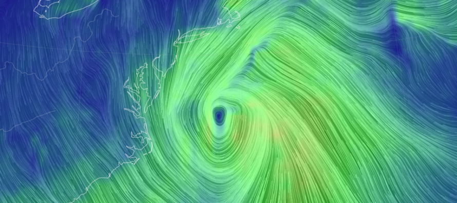
The reason the GFS and Canadian produced solutions further E is because of the way they handled the cyclonic vorticity upstream over the central/SW US. They separated the energy streams a little, allowing the S stream to hang behind. This then had downstream modeled impacts of a more progressive trough axis for the E US. The steering current upper-level stream lines were flatter instead of more meridional. This would allow the solution to drift E a bit while bombing out towards New England. The Euro remains locked on its solution because it has consistently modeled a better upstream interaction of the shortwaves allowing the vorticity to wrap up into a stronger phase for the E US. The trough axis mostly determines the track of the eventual coastal winter storm. The cyclonic vorticity determines its intensity. That’s why the Euro put a 974mb low on the 40N/70W BenchMark (BM) which is historically the most ideal coastal low location/track for most of NJ to experience a statewide snowstorm.
Moving forward through this evening and overnight model output, I’ll be looking specifically for this upstream interaction to consolidate further towards a timing consensus on the major longer-range models (GFS, Canadian, Euro). It will soon be time to consider the shorter range models like the NAM and RGEM as we step from the mid-range forecasting period into the short-range. Tonight the energy associated with the N stream moves off the Pacific and onto W Canada. It will be much better sampled for shortwave timing estimation.
Given the suggested intensity of the coastal low and track, we can probably expect the typical hazards that surround a strong winter storm. This includes gusty winds capable of producing power outages and coastal flooding via wind-driven storm surge. It’s a little too early to estimate these specific hazards but again, they would likely accompany such a system.
So, one more similar model suite tonight before I am all-in on this. Then, assuming that tomorrow morning’s 6z holds serve, we’ll enter winter storm mode tomorrow morning (social media cover images change). If we still look this way on Thursday night, I’ll change the social media profile images to the KABOOM logo. If we still look this way on Friday night, you will all hopefully be safe and buckling up.
In English: The chances of a major snowstorm are increasing this Friday night through Saturday. The pattern supports it. Recent model guidance supports it. I almost support it. One more night of data analysis tonight then I will support it tomorrow morning if the status quo maintains. Be safe! JC
Download the free Weather NJ mobile app on Apple or Android. It’s the easiest way to never miss Weather NJ content. Our premium services go even further above and beyond at the hyper-local level.
Jonathan Carr (JC) is the founder and sole operator of Weather NJ, New Jersey’s largest independent weather reporting agency. Since 2010, Jonathan has provided weather safety discussion and forecasting services for New Jersey and surrounding areas through the web and social media. Originally branded as Severe NJ Weather (before 2014), Weather NJ is proud to bring you accurate and responsible forecast discussion ahead of high-stakes weather scenarios that impact this great garden state of ours. All Weather. All New Jersey.™ Be safe! JC


LOCAL FORECAST | INTERACTIVE RADAR | LATEST NJ WEATHER ALERTS | WEDDING FORECAST| PRIVACY POLICY
© Copyright 2026 Weather NJ LLC. All Rights Reserved.
Some information that can be found on our website is provided by a private weather station and is not an officially recognized station for weather reporting. Though we always strive to achieve accurate reporting for our own use, it is important that you do NOT depend on the data provided here for any purpose.
