

Winter Storm Detected for Friday-Saturday
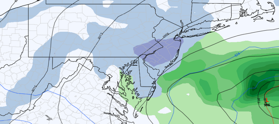
Discussion: A winter storm is targeting NNJ with plowable snowfall this Friday PM-Saturday AM. A primary low will track along the N stream into NWPA by Friday night. Energy will then transfer to a secondary low spawning just off Delmarva/OBX by early Saturday morning. The secondary low (offshore) will reach back to the upper-low (over NJ) and generate an area of lifting over NJ Saturday morning before everything pulls away by noonish Saturday or sooner. I think it’s best to break impacts down by state section N to S.
Areas along and N/NW of I-78: This should be the jackpot accumulation zone, which right now is somewhere in the 3-6/4-8 inch ballpark. Snow for this area is higher in confidence due to it being mostly from the primary N stream low plowing into colder air during overnight hours. I know it’s going to be in the 40s for high temperatures Friday and Saturday. It’s important to know that this region’s snowfall will occur when it’s 32 or less Friday night into early Saturday morning. Snowfall could push into NWNJ first by 7PM Friday and should end for this region during early Saturday AM hours.
Areas between I-95 and I-78: You might start as some initial rain Friday night prior to the low transfer (while I-78 and N are getting snow). Once the transfer happens likely just after midnight, cyclonic flow from the established secondary low will pull cold air down behind it. This should push the snow/rain line from the ~I-78 area down to the ~I-95 area immediately. This will likely still be prior to sunrise. For these reasons, areas between I-78<->I-95 and maybe just S of I-95 are still in the game for a general ballpark 2-4 inch snowfall. This would likely happen after midnight with the transfer and would conclude around sunrise Saturday morning.
Areas S/SE of I-95 have the lowest chance for accumulating snowfall, especially extreme SENJ (AC to Cape May). This region could approach 50 during the day Friday and will struggle to dip below 40 during most precipitation. This is mainly due to marine influence as ocean temps are near-40. The inverted trough-like lifting that should provide additional lifting for SNJ Saturday morning should also provide an E/SE flow off the ocean for this area S/SE of I-95. With all of that said, a mostly rain event could still end as snow Saturday morning however later in the morning when the sun is rising and temps are climbing. This area could get into the 1-3 inch zone closer to 95 but, for the most part, should expect little-to-no accumulation aside from natural surfaces only. Likely just wet roads S/SE of I-70.
Just a reminder that we are battling March climatology and higher sun-angle (more an issue SE of 95 Saturday morning with sun rising). Again, I am fully aware that Friday high temps will reach the mid-to-upper 40s…just as I am fully aware temps will drop to 32 or less overnight into early Saturday morning for I-95 and points N of I-95. It’s only areas S/SE of I-95 which will likely stay above freezing even at the coldest overnight point. Lastly, we rise back into the 40s for a quick melt on Saturday.
In English: A winter storm is brewing, mainly for NNJ, this Friday night into early Saturday morning. Those N/NW of I-78 should see the most amount of snow (3-6/4-8 inches) fall during colder overnight hours. Those between I-78 and I-95 should start as rain and change to snow while it’s still dark out (1-3/2-4 incehs). Those S/SE of I-95 should be mostly rain ending as a little snow later Saturday morning and see little-to-no snow accumulation (maybe C-1/2 closer to I-95). Winds still do not look bad with this…maybe some routine gusts to 40mph along the immediate coast Saturday morning but otherwise less away from the ocean. Coastal flooding is also a low concern given the short duration of inshore flow during mostly low tide hours.
Premium Services
KABOOM Club offers inside info forecast discussion, your questions answered, and early storm impact maps (ahead of the public). At 99 cents per month, it’s an extremely feasible way to show support.
My Pocket Meteorologist (MPM), in partnership with EPAWA Weather Consulting, offers professional/commercial interests, whose businesses depend on outdoor weather conditions (snow plowing, landscaping, construction, etc.), with hyper-local text message alerts/forecasts and access to the MPM premium forum—the most comprehensive and technical forecast discussion available for PA and NJ.
Jonathan Carr (JC) is the founder and sole operator of Weather NJ, New Jersey’s largest independent weather reporting agency. Since 2010, Jonathan has provided weather safety discussion and forecasting services for New Jersey and surrounding areas through the web and social media. Originally branded as Severe NJ Weather (before 2014), Weather NJ is proud to bring you accurate and responsible forecast discussion ahead of high-stakes weather scenarios that impact this great garden state of ours. All Weather. All New Jersey.™ Be safe! JC


LOCAL FORECAST | INTERACTIVE RADAR | LATEST NJ WEATHER ALERTS | WEDDING FORECAST| PRIVACY POLICY
© Copyright 2026 Weather NJ LLC. All Rights Reserved.
Some information that can be found on our website is provided by a private weather station and is not an officially recognized station for weather reporting. Though we always strive to achieve accurate reporting for our own use, it is important that you do NOT depend on the data provided here for any purpose.
