

Wintry Start to the Week (Jan 8-12)
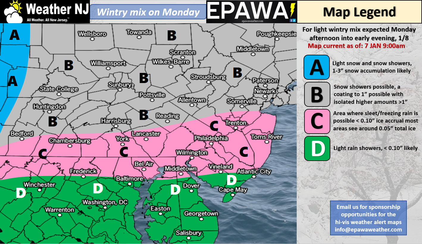
Please click here for full resolution snow map!
Discussion: The upper-levels indicate a back-and-forth pattern emerging as 500mb height anomalies bounce from positive to negative extremes. This is typical of the current La Nina state. Therefore we should moderate this week heading into the weekend followed by a colder next week followed by another thaw period in the January 19-25 period and likely back to cold after that (run-on sentence acknowledged). Exact dates of transition are hard to pin down but the general see-saw idea should play out. In the immediate time period, we have a short burst of moderate precipitation expected tomorrow night as a warm front pushes up into NJ. The above map represents our expected wintry impact.
In English: A light wintry event is likely tomorrow night. It’s not a big deal but should occur from PM rush hour through most of the evening. I recommend allowing a little extra time for travel, especially areas in the snow and ice zone of the map.
Monday (Jan 8) high temperatures should range from upper-20s to mid-30s NNJ to SNJ. Skies should be mostly cloudy with snow, ice and rain possible (see wintry impact map above). NNJ is most favored for snow. SNJ is most favored for rain. CNJ is looking like an icy/mix between. Winds should be light-to-breezy out of the S/SW, a little breezier for SNJ/SENJ. Overnight lows should range from mid-20s to lower-30s NNJ to SNJ.
Tuesday (Jan 9) high temperatures should range from upper-30s to lower-40s NNJ to SNJ. Skies should be partly sunny. Winds should be light out of the W/NW. Overnight lows should fall into the teens/20s statewide.
Wednesday (Jan 10) high temperatures should range from 35-40 NNJ to SNJ. Skies should be partly sunny. Winds should be light out of the E. Overnight lows should range from upper-20s to mid-30s NNJ to SNJ.
Thursday (Jan 11) high temperatures should reach the upper-40s/lower-50s statewide. Skies should be mostly cloudy with rain possible. Winds should be light out of the S. Overnight lows should only fall a few degrees lower than high temperatures so low-to-mid 40s statewide.
Friday (Jan 12) high temperatures should reach well into the 50s statewide. Skies should be mostly cloudy with rain likely. Winds should remain light out of the S. Overnight lows should fall into the 30s for most, perhaps upper-20s for NNJ and lower-40s for extreme SNJ.
An early look at the weekend indicates warm and rainy conditions spilling into Saturday. Sunday and beyond (into next week) indicates the return back to below-average temperatures but not as cold as it’s been.
For comprehensive and interactive hyper-local analysis that goes way above and beyond the detail of this public forecast, check out our premium services which include text notifications and forum access.
Jonathan Carr (JC) is the founder and sole operator of Weather NJ, New Jersey’s largest independent weather reporting agency. Since 2010, Jonathan has provided weather safety discussion and forecasting services for New Jersey and surrounding areas through the web and social media. Originally branded as Severe NJ Weather (before 2014), Weather NJ is proud to bring you accurate and responsible forecast discussion ahead of high-stakes weather scenarios that impact this great garden state of ours. All Weather. All New Jersey.™ Be safe! JC


LOCAL FORECAST | INTERACTIVE RADAR | LATEST NJ WEATHER ALERTS | WEDDING FORECAST| PRIVACY POLICY
© Copyright 2026 Weather NJ LLC. All Rights Reserved.
Some information that can be found on our website is provided by a private weather station and is not an officially recognized station for weather reporting. Though we always strive to achieve accurate reporting for our own use, it is important that you do NOT depend on the data provided here for any purpose.

)