

Long Range Outlook: June 2016

It’s time to harness the WeatherTrends360 proprietary weather algorithms to see how June 2016 should play out. But first lets break New Jersey into proper climatological regions. We have the higher elevations of NNJ/NWNJ, the interior coastal plain (SWNJ through CNJ and into NENJ), and the coastal regions (most of SENJ). I’ll be representing each climatological region with a 28-day graph from weathertrends360 data followed by a brief discussion. Please keep in mind that these algorithms are documented with an 84% verification rate and are based on oceanic water cycles and time table series. Do not focus on specific detailed daily forecasts (sun vs clouds, etc). Focus on general trends (cool vs warm, rainy vs dry, etc). That’s what WeatherTrends360 does best.
Higher Elevations of NNJ/NWNJ
(Sussex, Warren, Hunterdon, Morris, N. Somerset, and N. Passaic) – Known for little to no Atlantic Ocean influence, colder-snowier winters, and drier conditions in general when compared to the coast. This region is known to get hot when high pressure sits overhead during the summer and bitterly cold during Arctic outbreaks in the winter.
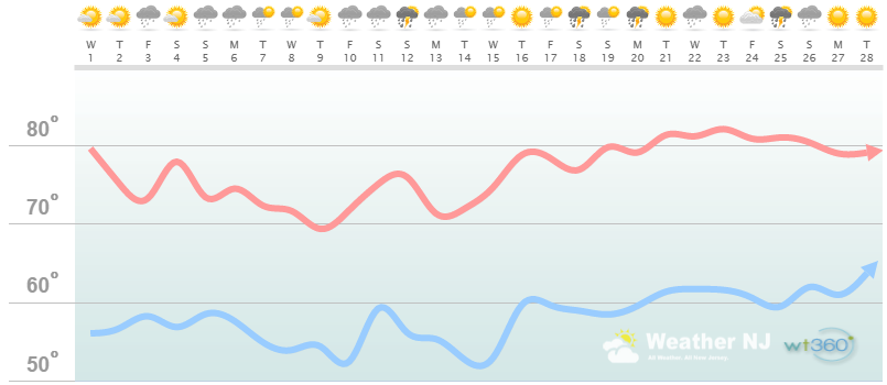
Higher Elevation Discussion: Just like we saw with May, June will feature no shortage of rainfall. Rain showers and thunderstorms should frequently blanket the month. However, that’s not to say there wont be beautiful sunny days checkered between. The upper-level pattern is still a bit insulted, embarrassed and disturbed from the rapidly decaying El Nino, PDO influence and a few other anomalies. This has kept New Jersey and most of the Mid-Atlantic/Northeast US in a pattern of troughing and upper-level low pressure systems (cooler and wet). This should continue through the first half of June or so (maybe the first 2/3 of June) and then rapidly give way to a hot summer pattern once the E US ridge builds and takes over. Until that happens, we’re talking high temperatures in the 70s (maybe a few days flirt with 80). Some might say it’s the spring we never had. Once summer snaps in to finish up June, 80s+ will be common in this region.
Interior Coastal Plain from SWNJ-CNJ-NENJ
(Salem, Gloucester, Camden, W. Burlington, Mercer, W. Monmouth, Middlesex, S. Somerset, Union, Essex, Hudson, Bergen, and S. Passaic) – Known for naturally higher temperatures due to lower elevations away from the oceanic influence. This region is also known as “heat island” due to transportation (I-95 corridor), smog, abundant asphalt, concrete, and other man-made substances that naturally absorb and retain heat moreso than natural protected land.
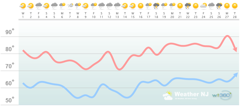
Interior Coastal Plain Discussion: Just like we saw with May, June will feature no shortage of rainfall. Rain showers and thunderstorms should frequently blanket the month. However, that’s not to say there wont be beautiful sunny days checkered between. The upper-level pattern is still a bit insulted, embarrassed and disturbed from the rapidly decaying El Nino, PDO influence and a few other anomalies. This has kept New Jersey and most of the Mid-Atlantic/Northeast US in a pattern of troughing and upper-level low pressure systems (cooler and wet). This should continue through the first half of June or so (maybe the first 2/3 of June) and then rapidly give way to a hot summer pattern once the E US ridge builds and takes over. Until that happens, we’re talking high temperatures in the 70s (some days reaching 80). Some might say it’s the spring we never had. Once summer snaps in to finish up June, 85+ will be common in this region.
Coastal Regions of SENJ
(Cumberland, Cape May, Atlantic, E. Burlington, Ocean, and E. Monmouth) – Known for tremendous influence from the Atlantic Ocean. Oceanic influence keeps this zone cooler in the summer and warmer in the winter than the interior coastal plain and especially the higher elevations of NWNJ. This forms a micro-climate that only local inhabitants and frequent visitors are familiar with.
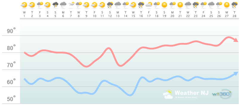
Coastal Region Discussion: Just like we saw with May, June will feature no shortage of rainfall. Rain showers and thunderstorms should frequently blanket the month. However, that’s not to say there wont be beautiful sunny days checkered between. The upper-level pattern is still a bit insulted, embarrassed and disturbed from the rapidly decaying El Nino, PDO influence and a few other anomalies. This has kept New Jersey and most of the Mid-Atlantic/Northeast US in a pattern of troughing and upper-level low pressure systems (cooler and wet). This should continue through the first half of June or so (maybe the first 2/3 of June) and then rapidly give way to a hot summer pattern once the E US ridge builds and takes over. Until that happens, we’re talking high temperatures in the 70s (some days reaching 80). Some might say it’s the spring we never had. Once summer snaps in to finish up June, 80+ will be common in this region. Remember though, as days enter the afternoon period, sea breeze fronts can back in off the ocean and cool temperatures 10-15 degrees below interior New Jersey. For this reason, you might see days of 85-90 along the I-95 corridor and 70-75 along the immediate coast. Just keep that in mind.
Some extra language I would like to add for the coastal regions involves the natural micro-climate phenomena known as a sea breeze front. This happens primarily due to the hotter surface temperatures inland vs the cooler surface temperatures of the ocean. The interior hotter surface temperatures create lift which pulls air off the ocean to replace the interior rising air. This creates a mini-cold front that backs in off the ocean. It can contribute to fog and even trigger thunderstorms (like a traditional cold front from the W/NW) when there is enough instability present. These thunderstorms are mostly shear-less air-mass thunderstorms and therefore contain downpours with very little movement. I’ll point these out if/when they happen. Right now a sea breeze is mildly offensive as the Atlantic is only 51-52F. In the peak summer its much more pleasant as the Atlantic is in the 70-78 range making the sea breeze feel like natural air condition when it displaces 90F+ conditions. We need to get into June before the coast can escape the unpleasant/colder influence of the ocean. Basically when ocean temps get above 60F.
Hurricane season has started and we are already on the letter C for the next named storm. With relaxed Caribbean shear, low Saharan dust and extremely warm sea surface temperature anomalies off the Mid-Atlantic coast, this year must be taken seriously. All of the above does not gaurantee a tropical system will hit New Jersey. It does however mean that should a system form and head our way, there will be little to weaken it. Follow my Eye Wall for Atlantic tropics information.

In English: The most important takeaway should be peak annual sun angle this month. This will allow the first half-to-2/3 of June to still climb into the 70s and flirt with 80 despite colder air aloft for this time of year. At least the last third of June should end hot and summery. Precipitation should be plentiful throughout the entire month, scattered around beautiful days. Precipitation should be produced moreso from instability-driven showers and thunderstorms rather than widespread washouts. We’ll take thunderstorm threats every 3-4 days at a time. Have a great month and be safe! JC
Weathertrends360 is a complete, global, web solution to help retailers and suppliers capitalize on the weather and its influence on sales and marketing plans up to a year ahead. Learn how to become PROACTIVE vs REACTIVE with the weather in every phase of your business – how much inventory to buy/produce, where to allocate more/less, when to run weather-optimized advertising/marketing campaigns – weathertrends360 can help you determine all of this in minutes! 84% independently audited accuracy for both short-term and year-ahead forecasts for temperature and precipitation.
A forecast Weather Trends issued one year ago is more accurate than every other weather company’s 5 to 14-day forecasts. The University of Miami and West Point PhD Climatologist’s prove WTI’s year-ahead forecasts are several times more accurate than NOAA – Click to Download Report. Also check out their free txt and email alerts!
Image Credit: Disney, retrieved from Google Images under the “available for reuse” filter.
Jonathan Carr (JC) is the founder and sole operator of Weather NJ, New Jersey’s largest independent weather reporting agency. Since 2010, Jonathan has provided weather safety and forecasting services for New Jersey and immediate surrounding areas through the web, social media, and app spaces. Originally branded as Severe NJ Weather (before 2014), Weather NJ is proud to bring you accurate and responsible discussions ahead of high-stakes weather scenarios that impact the garden state. All Weather. All New Jersey.™


LOCAL FORECAST | INTERACTIVE RADAR | LATEST NJ WEATHER ALERTS | WEDDING FORECAST| PRIVACY POLICY
© Copyright 2024 Weather NJ LLC. All Rights Reserved.
Some information that can be found on our website is provided by a private weather station and is not an officially recognized station for weather reporting. Though we always strive to achieve accurate reporting for our own use, it is important that you do NOT depend on the data provided here for any purpose.
