


Possible Nor’easter Detected

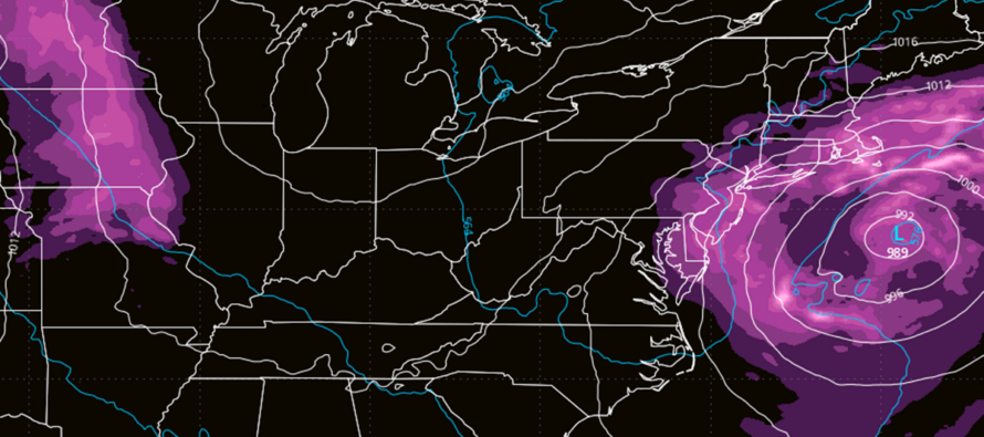
Discussion: I know we’ve been looking at this possibility for a bit in KABOOM Club. I wish to emphasize the uncertainty mainly due to a complex system of moving parts (phasing, etc.) having to come together just perfectly for the NJ hit scenario. Sounds familiar, right? Yes, we’ll be doing this song and dance in a few months with coastal snowstorms. But for this system, precipitation type will be all rain.
General weather media has absolutely jumped the shark with this system. I’m seeing anything from smaller amateur outlets all the way up to well-known pros (including some CDM) hyping the crap out of this. My goal today is to offer a grounding voice of reason.
First, I want to briefly discuss the rainiest periods between now and when the coastal storm sets up around Friday night. As I stated on Friday in the weekend outlook, we should not expect continuous rain from this past Sunday (yesterday) through this weekend. Instead, periods of rain in mostly cloudy/gloomy conditions. Our next batch of rain pushes in this evening/overnight (Monday into Tuesday possibly into Wednesday). SNJ looks the wettest over this period. Thursday and Friday should be more of a light mist coming off the ocean on-and-off…but still gloomy. Now let’s talk weekend coastal storm.
We do potentially have a trifecta of rain, wind-driven storm surge and a full moon Saturday. So, if this system does phase perfectly for a NJ hit, then coastal flooding issues could be worse than expected. However, even if the physics do not come together, keeping the storm out to sea, I still think higher expectations of coastal flooding are on the table. Remember, there is a broad elongated high pressure over Canada that is sending flow down and around the front of it back in towards NJ…the reason for the prolonged onshore flow this week. This is already pushing ocean water into the NJ coast. Couple that with even a near-miss of the coastal storm and we are likely looking at increased coastal flooding risks regardless of rain and wind.
Rain and wind will be determined by how close the storm gets to NJ. Does it organize, wrap up and retrograde towards NJ or does it stay unorganized out to sea with delayed capture/phase mechanisms? A closer track would mean more rain and wind for all of NJ. An out to sea miss would mean possibly only extreme ENJ/SENJ sees some rain and wind. This is still uncertain and I am perfectly comfortable stating such. I’d rather narrow the range of possibilities as we approach and confirm rather than just say “NOR’EASTER COMING!!!” This isn’t a Sandy situation where the Euro was deadlocked on a hit every run from 9 days out. There is a lot of uncertainty, and this storm will not be another Sandy, at least wind wise. Coastal flooding impacts will be determined by how close the storm gets during the Saturday full moon. Even still, I don’t see Sandy water levels from that.
If it does hit, the days/hours of impact are from late Friday night through early Monday morning, with peak conditions occurring for NJ Saturday-Sunday. I will be updating daily at this point. I will not be ready to make a go vs. no-go decision until Wednesday night at the earliest. But I will keep you updated each day where the data stands and any upstream live observations that might change the outcome.
In English: Expect more periods of rain to pass through NJ from W to E between tonight and Friday morning. SNJ should see more rain than NNJ in that period. A coastal storm will then form off OBX late Friday night/early Saturday morning and either hit all of NJ directly or stay just far enough out to sea to miss/bring fringe impacts (rain and wind) to coastal NJ only. Storm track will determine rain and wind impacts. But regardless of storm track, I think coastal NJ is in for a little more coastal flooding than expected. Full moon Saturday + this prolonged onshore flow this week = a lot of ocean water sent into NJ. I will provide daily updates from this point forward which will get a little more confident each post. Go vs. No-go decision will be made Wednesday evening at the earliest. This is the best non-hype analysis I can provide about this potential system 6 days out. Have a great rest of your Monday and please be safe! JC
Premium Services
KABOOM Club offers an ad-free environment, inside info (Above and Beyond) forecast discussion, your questions prioritized, and early storm impact maps and video releases (ahead of the public). At $1.99 per month, it’s an extremely feasible way to show additional support for Weather NJ and you can turn it on and off for however many months you wish. Think of it as a tip jar with perks. Available onFacebook or Patreon.
My Pocket Meteorologist (MPM), in partnership with EPAWA Weather Consulting, offers professional/commercial interests, whose businesses depend on outdoor weather conditions (snow plowing, landscaping, construction, etc.), with hyper-local text message alerts/forecasts from real meteorologists and access to the MPM premium forum—the most comprehensive and technical forecast discussion available for PA and NJ commercial interests.
KABOOM Shop is live if you want some KABOOM or Weather NJ Merch!

Jonathan Carr (JC) is the founder and sole operator of Weather NJ, New Jersey’s largest independent weather reporting agency. Since 2010, Jonathan has provided weather safety discussion and forecasting services for New Jersey and surrounding areas through the web and social media. Originally branded as Severe NJ Weather (before 2014), Weather NJ is proud to bring you accurate and responsible forecast discussion ahead of high-stakes weather scenarios that impact this great garden state of ours. All Weather. All New Jersey.™ Be safe! JC



LOCAL FORECAST | INTERACTIVE RADAR | LATEST NJ WEATHER ALERTS | WEDDING FORECAST| PRIVACY POLICY
© Copyright 2026 Weather NJ LLC. All Rights Reserved.
Some information that can be found on our website is provided by a private weather station and is not an officially recognized station for weather reporting. Though we always strive to achieve accurate reporting for our own use, it is important that you do NOT depend on the data provided here for any purpose.

