


Nor’easter a GO!

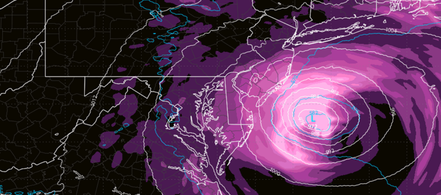
Discussion: We’ve beaten the physics of this nor’easter setup to death this week. Organizing low pressure off the SE US/OBX phased into low that will run into a block. The block will trap the storm into at least a stall/retrograde but possibly into a loop towards the Jersey shore. It’s time to move on from physics and focus on actual expected impacts.
Note: Whenever there is a coastal storm of any magnitude, areas away from the ocean see a different story than those living along the ocean or communities affected by tidal flooding. While wind-related power outages and heavy rainfall could be common statewide, the coast usually takes the worst of the winds. This is because air just above the ocean is more dense than air just above land. Therefore a downward mechanism happens where the winds dive and shear out on the surface physics. So when a coastal storm delivers gusts to 60mph along the immediate coast, areas away from the coast typically see a majority fraction of such…so maybe 35-45mph. Sometimes people on the coast complain about a coastal storm and those away from the ocean say “What storm?” Just keep this in mind. Let’s break the system down by impacts and timing:
Rain: There might be some raw misty stuff around this evening and Friday but should noticeably transition to heavier rainfall by early Saturday AM. I’m expecting on-and-off periods of rain to last through the rest of Saturday, all of Sunday and tapering off Monday.
Wind: The coast is already feeling the onshore flow. I’m seeing 20-30mph along the beaches already but only 10-15mph away from the ocean (see above note). It will likely stay like this through Friday night. Winds should then step up late-Friday night into Saturday morning and peak until about Sunday afternoon. During this peak stretch, winds could gust to 60mph, possibly higher along the coast. Areas away from the ocean would be more in the 25-40mph range. Also during this peak stretch, wind direction should gradually change counter-clockwise from E/NE to NE to N/NE to N. This places the worst onshore flow Friday night and Saturday morning. After that, wind changes to N/NE or N and stops pushing water into the coast. And that’s not to say the N winds won’t still crank Saturday night into Sunday. Winds would then gradually subside from Sunday night into Monday with significant improvement by Monday afternoon/evening.
Coastal Flooding: This is still the headliner IMO. Full moon Saturday night during the greatest wind-driven storm surge window. This makes the Friday night (~10pm) and Saturday morning (~930am) high tides the two high tides of concern. Tidal guidance is now suggesting moderate-to-major up and down the NJ coast. I am already seeing water in the streets now that the high to the N and outer fringe of developing low are squeezing the pressure gradient.
In English: The above discussion breaks down the impact of this weekend’s nor’easter by category and suggested timing. It should be straightforward (already in English). The model guidance has trended towards the original Euro solution (a harder NJ hit) and this thing is already starting for the coast wind-wise. I think this will be run-of-mill rain and wind for solid nor’easter. But I think tidal/coastal flooding has the potential to surprise. Is that guaranteed? No, coasties could easily walk away with just run-of-mill water in the streets. But with the full moon and potential for the storm to loop in towards NJ, I would err on the side of caution. Pay attention to local authorities/announcements. Follow your community social media groups. Stay informed just in case this continues in the wrong direction. That’s about all I have to say for now. YouTube video coming later tonight…probably in the 9-10pm window. Be safe! JC
Premium Services
KABOOM Club offers an ad-free environment, inside info (Above and Beyond) forecast discussion, your questions prioritized, and early storm impact maps and video releases (ahead of the public). At $1.99 per month, it’s an extremely feasible way to show additional support for Weather NJ and you can turn it on and off for however many months you wish. Think of it as a tip jar with perks. Available onFacebook or Patreon.
My Pocket Meteorologist (MPM), in partnership with EPAWA Weather Consulting, offers professional/commercial interests, whose businesses depend on outdoor weather conditions (snow plowing, landscaping, construction, etc.), with hyper-local text message alerts/forecasts from real meteorologists and access to the MPM premium forum—the most comprehensive and technical forecast discussion available for PA and NJ commercial interests.
KABOOM Shop is live if you want some KABOOM or Weather NJ Merch!

Jonathan Carr (JC) is the founder and sole operator of Weather NJ, New Jersey’s largest independent weather reporting agency. Since 2010, Jonathan has provided weather safety discussion and forecasting services for New Jersey and surrounding areas through the web and social media. Originally branded as Severe NJ Weather (before 2014), Weather NJ is proud to bring you accurate and responsible forecast discussion ahead of high-stakes weather scenarios that impact this great garden state of ours. All Weather. All New Jersey.™ Be safe! JC



LOCAL FORECAST | INTERACTIVE RADAR | LATEST NJ WEATHER ALERTS | WEDDING FORECAST| PRIVACY POLICY
© Copyright 2026 Weather NJ LLC. All Rights Reserved.
Some information that can be found on our website is provided by a private weather station and is not an officially recognized station for weather reporting. Though we always strive to achieve accurate reporting for our own use, it is important that you do NOT depend on the data provided here for any purpose.

