


Nor’easter Dissolves and Departs

Discussion: I want to reemphasize a few points. Awesome followers can skip this paragraph. Throughout this entire week, I maintained that areas away from the ocean would see a run-of-mill manageable rain and wind event experienced many times before. I emphasized that my primary concern was for immediate Jersey shorelines in ECNJ/SENJ…communities affected by tidal water levels and peak wind gusts off the ocean. You can check tape of YouTube and read the lead-up articles. So, if you’re wondering why you didn’t get annihilated in places like Warren or Camden Counties, take that energy somewhere else. Because the notion that you would…never came from here. If you are in places like Surf City/Beach Haven on Long Beach Island and are wondering why you now have major flood damage without adequate notification/preparation, I only wish you found us sooner. If you did just discover Weather NJ, welcome aboard. Weather NJ’s primary mission is to translate complex meteorology into layman’s terms (“In English”) so that actionable safe decisions can be made around life’s (New Jersey’s) random weather conditions. The last thing you need is hype leading into a stressful hazardous weather situation. If we are strongly opinioned about a potential weather safety awareness issue, that means it’s a real possibility, not an instrument for bait-and-switch financial gain. If I am slapping the word KABOOM on a snowstorm (12 inches of snow or more), it’s not for hype, revenue or personal interests. It won’t be done 5 days ahead of the snowstorm. It will be called for the day before the storm once all possibilities of a non-KABOOM are ruled our with evidence-based science. If I say: “Possible Nor’easter Detected” 6 days ahead, I mean it because I’ve recognized the pattern, analyzed data evidence and made an affirmation, based on local experience, that I believe it really is possible. </end rant>
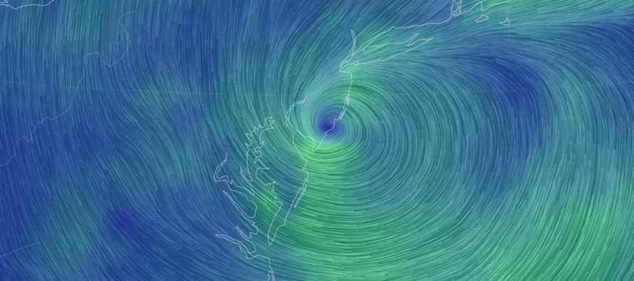
We’re now heading into the sunset of this nor’easter. A quick recap: The heaviest rainfall occurred late-Friday night into Saturday morning and Saturday night into Sunday morning. The highest winds occurred late Friday night into Saturday morning where a gust of 74mph was clocked in Surf City, NJ. Winds are back up today but not to the level of early Saturday AM. There were several periods of lulls where rain ceased, and winds calmed (Saturday daytime and today-now). As expected, the heaviest rainfall amounts and highest winds were confined to the coastal areas of concern. Coastal flooding reached major criteria for many coastal locations in ECNJ/SENJ…”the worst flooding since Sandy” as described by more than a few locals. The worst high tide was the first Saturday cycle, especially for the southern Jersey shore. But the few surrounding high tides, including today’s were NLT moderate criteria. Today’s high tide brought some of the highest water levels to the northern Jersey shore…areas who did not see as high of water levels Saturday morning. I’ve seen imagery of 2-3 feet of water into first stories of homes and restaurants. This was a little more than the “this happens all the time/routine water in the streets” comments I’ve been seeing. I wouldn’t have taken you through a week of content if I believed that’s all this would be. The low itself formed from an organization of broad energy phasing off the SE US. The energy formed into a single low, crossed northward over the warm Gulf stream, hit a high-pressure block and had nowhere to turn but W towards NJ. This is very different than a capture like Sandy. This nor’easter wasn’t pulled in by an upper-low, it was already stacked near that. It was pushed in by steering currents aided by a polar Canadian high return flow conveyor belt. To understand the rest of this system, please have a look at the following graphic:
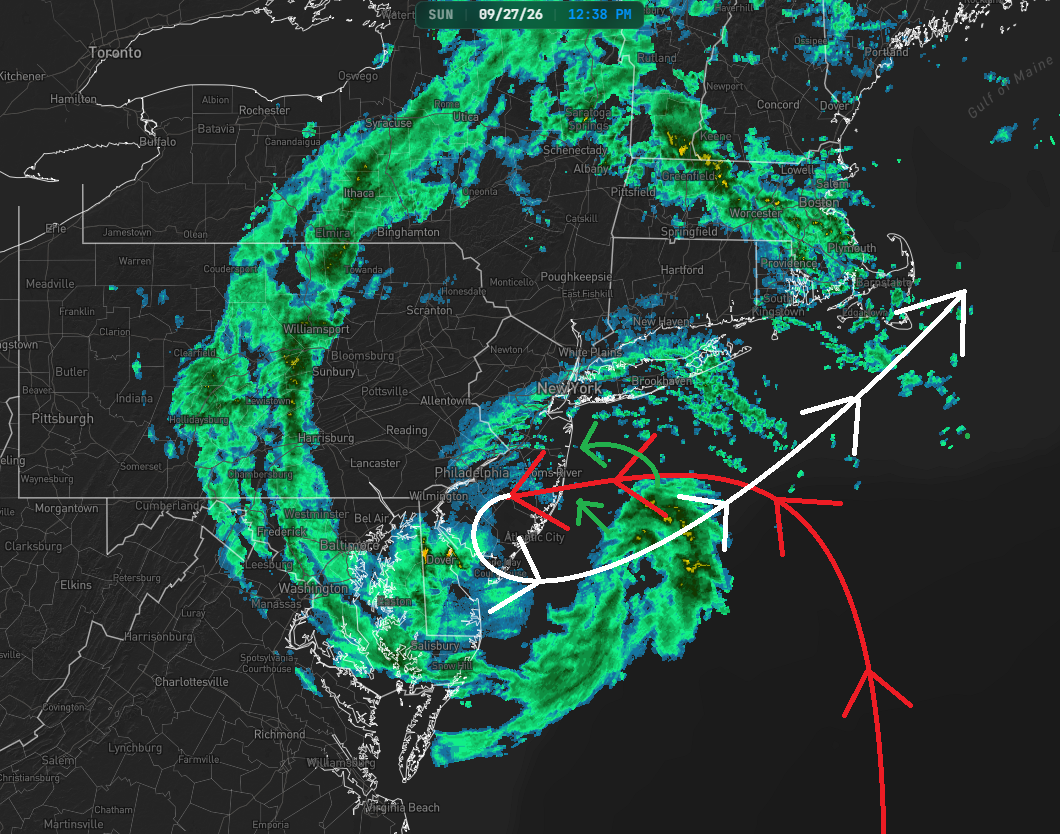
The red arrowed line indicated the past recorded low track. The white arrowed line indicated the expected future track through ~Monday afternoon/evening. Today (Sunday), we’ll have the low looping around SNJ/SENJ as shown in the track. See that rain off SENJ? The looping low will bring that into NJ this afternoon/evening before clearing out later tonight/overnight. This will be manageable rain and wind for all areas including the coast. By Tuesday night I expect high tide levels to return to normal water levels. That leaves 3-4 high tides between now (Sunday 1pm) and then. Each of those three could still feature minor-to-moderate tidal flooding but should gradually decline in level with each tide. There should be no more coastal areas experiencing major coastal flooding from this point forward. This morning’s high tide should be the last of that. Onshore flow will persist however given the position of the looping low and the onshore winds to the N of it. This will fight draining back bays and estuaries and that is the reason for the gradual recission of water levels rather than rapid recission.
In English: The worst of the system is over. Areas away from the ocean saw manageable rain and wind while the ECNJ/SENJ coast was battered with a top 10 historic nor’easter. We will now gradually continue improvement through the rest of today into Monday. A little more rain and wind (breezy/gusty out of the N) tonight but very run-of-mill type stuff. Looking forward, I can tell you that everything will feel noticeably thrusted towards the colder season. By Monday night, the system will be well to our E/NE and colder air will drive in behind it through at least Thursday. When the sun hides behind clouds and rain for days at a time this time of year, you lose sense of how late the sun is rising and how early it is setting. So, the first clear day (Monday night maybe Tuesday), expect a lot of, “oh wow it’s really starting to get dark early.” A funny psychology quirk I’ve noticed. After a super brief one day or so moderation (~Thursday-Friday) I’m then seeing some very anomalous cold moving in around October 3. October looks to start cold. It almost feels like we skipped from mid-August to mid-October with very little traditional September weather conditions. I think I was swimming in an 80-degree pool a few weeks ago yet I might need to turn the heat on this coming Friday night.
At some point this week I will write a full storm recap, but it will be geared towards a historical storm series I am creating. The series will start with the most recent current event and work backwards through historical nor’easters, hurricanes and snowstorms. I’m talking back through Sandy, 1962, 1944, 1907, 1851, whatever big event happened between 1250-1450, just to name a few. The articles will feature accompanying videos and they will be static timeless Weather NJ content, not articles that fade away after a few days of relevancy. I hope you enjoy it! Have a great rest of your Sunday and please be safe! JC
Premium Services
KABOOM Club offers an ad-free environment, inside info (Above and Beyond) forecast discussion, your questions prioritized, and early storm impact maps and video releases (ahead of the public). At $1.99 per month, it’s an extremely feasible way to show additional support for Weather NJ and you can turn it on and off for however many months you wish. Think of it as a tip jar with perks. Available on Facebook or Patreon.
My Pocket Meteorologist (MPM), in partnership with EPAWA Weather Consulting, offers professional/commercial interests, whose businesses depend on outdoor weather conditions (snow plowing, landscaping, construction, etc.), with hyper-local text message alerts/forecasts from real meteorologists and access to the MPM premium forum—the most comprehensive and technical forecast discussion available for PA and NJ commercial interests.
KABOOM Shop is live if you want some KABOOM or Weather NJ Merch!

Jonathan Carr (JC) is the founder and sole operator of Weather NJ, New Jersey’s largest independent weather reporting agency. Since 2010, Jonathan has provided weather safety discussion and forecasting services for New Jersey and surrounding areas through the web and social media. Originally branded as Severe NJ Weather (before 2014), Weather NJ is proud to bring you accurate and responsible forecast discussion ahead of high-stakes weather scenarios that impact this great garden state of ours. All Weather. All New Jersey.™ Be safe! JC



LOCAL FORECAST | INTERACTIVE RADAR | LATEST NJ WEATHER ALERTS | WEDDING FORECAST| PRIVACY POLICY
© Copyright 2026 Weather NJ LLC. All Rights Reserved.
Some information that can be found on our website is provided by a private weather station and is not an officially recognized station for weather reporting. Though we always strive to achieve accurate reporting for our own use, it is important that you do NOT depend on the data provided here for any purpose.

