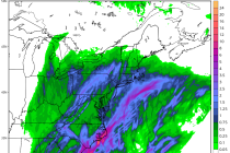
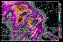
Back to homepage

Latest NJ Weather Alerts

Feb 16: Snow Storm Approaching!

Feb 16: Snow Storm Approaching!

🕔09:50, 16.Feb 2015

I’m going to keep it nice and simple. A low pressure system will be moving across the SE US and ejecting into the Atlantic Ocean near OBX. It will then take a track SE of the benchmark (40N/70W) before moving

Read Full Article
Feb 15: Tuesday Snow Storm Detected!

Feb 15: Tuesday Snow Storm Detected!

🕔12:08, 15.Feb 2015

New Jersey will likely see another snow event this Tuesday. A low pressure disturbance, currently approaching W. Texas, will track across the SE US before ejecting into the Atlantic Ocean over OBX and passing over the benchmark. The system appears

Read Full Article
Feb 14: Winter Storm Update

Feb 14: Winter Storm Update

🕔18:19, 14.Feb 2015

Here’s my final call for tonight through tomorrow. Everything looks a little bit south which is why the heaviest snowfall has been shifted to CNJ and parts of SNJ. While all of NJ should see at least light snowfall, I

Read Full Article
Feb 13: Weekend Winter Storm Update

Feb 13: Weekend Winter Storm Update

🕔21:08, 13.Feb 2015

We’re now under 24 hours away from winter storm impact in New Jersey. The clipper is riding in from the NW and will transfer to the ocean near Delmarva/SNJ tomorrow evening. It will then bomb out and give coastal New

Read Full Article
Wintry Weekend Expected (Feb 13-15)

Wintry Weekend Expected (Feb 13-15)

🕔09:57, 13.Feb 2015

The coldest period of the season so far is approaching. The weekend starts bitterly cold, peaks with a snow storm Saturday evening into Sunday morning and then closes out even colder than it started. Let’s break it down: Friday highs will

Read Full Article
Feb 12: Initial Weekend Snow Map & Discussion

Feb 12: Initial Weekend Snow Map & Discussion

🕔16:42, 12.Feb 2015

The Arctic outbreak of cold air is the main story which begins tonight, peaks between Sunday-Monday and lasts well into next week. As far as snow potential goes, it’s now time to focus on the Saturday-Sunday period. Another clipper will

Read Full Article
Feb 11: What to Expect for Thursday-Friday

Feb 11: What to Expect for Thursday-Friday

🕔19:23, 11.Feb 2015

A weak clipper system is currently moving in from the W/NW. It will transfer to the coast and intensify as it pulls away but probably too late for any substantial impact to New Jersey. All I’m going to leave on

Read Full Article
Feb 10: Watching Two Snow Possibilities

Feb 10: Watching Two Snow Possibilities

🕔19:10, 10.Feb 2015

We’re now in the heart of peak snow season in the mid-Atlantic US. Hours of sunlight are increasing daily by minutes but coastal ocean sea surface temperatures are bottoming out for the year in the upper 30s. This is a big

Read Full Article
Feb 10: Arctic Outbreak Detected!

Feb 10: Arctic Outbreak Detected!

🕔11:24, 10.Feb 2015

Models are unanimously in agreement about a very cold period in the ~February 13-18 time-frame. A piece of the Polar Vortex will break off and drop over the E. US. The trough could reach as far south as Florida. This is

Read Full Article
Feb 9: Watching Thursday-Friday for Snow

Feb 9: Watching Thursday-Friday for Snow

🕔11:48, 9.Feb 2015

As today’s disturbance moves away by early Tuesday morning, it will pull down cold air behind it from the north. A clipper is modeled to move across the Great Lakes and transfer southward to a coastal low formation this Thursday-Friday.

Read Full Article