


Coastal Transfer Underway

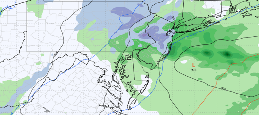
Discussion: While not a nor’easter, we do have some interesting physics in the atmosphere. As I mentioned earlier this week, there’s a lot of energy surrounding this system, it’s just failing to phase together into a single powerful low. We do however have a weak low, currently tracking across SW PA from W to E. This low will eventually track across/transfer across NJ/Delmarva and become part of an inverted trough off the Mid-Atlantic US before pulling away. This leaves no prolonged NE wind component however it offers additional lifting in the current warm sector over NJ. For this reason, there has been some hail and tornado interest generated around the shear-producing low as it moves through NJ this afternoon/evening.
The hail and tornado potential appears to be targeting CNJ with the best dynamics with NNJ and SNJ on the hook but not as much. This stormy set of dynamics should push through NJ between now and about 8PM this evening from SWNJ through NENJ (moving SW to NE).
Once this is through, the low then moves offshore and becomes part of the inverted trough for Friday. Because there’s an inverted trough involved, precipitation rates could enhance to the point of brining mixed snow and rain further SE into NJ (not just NWNJ). The surface however will remain above 38F for all surface areas (above 40F for much of NJ) so stickage not really possible outside of a very wet snow scenario for NWNJ. And I am still suspicious about even that.
The overall forecast has not changed much… a nuisance period of unsettled conditions (rain possible, light-to-moderate winds) between today and early Saturday AM. We just now have the potential for localized instances of severe weather (wind gusts, hail, tornado) this afternoon as very thin strips of moderate-to-heavy downpours push through (with sunny gaps between).
In English: Showers, thunderstorms, hail and even a tornado are possible between this afternoon-evening. Very isolated not widespread for hail and tornado possibility. We then see a lull later tonight into tomorrow morning as more rain and N winds are possible Friday. The hail and tornado threat ends later this evening (Thursday evening). Time to take this to live observations on radar. Have a great rest of your Thursday and please be safe! JC
Premium Services
KABOOM Club offers an ad-free environment, inside info (Above and Beyond) forecast discussion, your questions prioritized, and early storm impact maps and video releases (ahead of the public). At $1.99 per month, it’s an extremely feasible way to show additional support for Weather NJ and you can turn it on and off for however many months you wish. Think of it as a tip jar with perks. Available on Facebook or Patreon.
My Pocket Meteorologist (MPM), in partnership with EPAWA Weather Consulting, offers professional/commercial interests, whose businesses depend on outdoor weather conditions (snow plowing, landscaping, construction, etc.), with hyper-local text message alerts/forecasts from real meteorologists and access to the MPM premium forum—the most comprehensive and technical forecast discussion available for PA and NJ commercial interests.
KABOOM Shop is live if you want some KABOOM or Weather NJ Merch!

Jonathan Carr (JC) is the founder and sole operator of Weather NJ, New Jersey’s largest independent weather reporting agency. Since 2010, Jonathan has provided weather safety discussion and forecasting services for New Jersey and surrounding areas through the web and social media. Originally branded as Severe NJ Weather (before 2014), Weather NJ is proud to bring you accurate and responsible forecast discussion ahead of high-stakes weather scenarios that impact this great garden state of ours. All Weather. All New Jersey.™ Be safe! JC



LOCAL FORECAST | INTERACTIVE RADAR | LATEST NJ WEATHER ALERTS | WEDDING FORECAST| PRIVACY POLICY
© Copyright 2026 Weather NJ LLC. All Rights Reserved.
Some information that can be found on our website is provided by a private weather station and is not an officially recognized station for weather reporting. Though we always strive to achieve accurate reporting for our own use, it is important that you do NOT depend on the data provided here for any purpose.

