

Dec 2: Rain to Possible Snow Detected
Discussion: The upper level low/trough that brought Monday’s storm and the current colder conditions is currently lingering over SE Canada and the NE US. There is also an upper level low in the interior SW US trapped under strong W US ridging (hence the current strong +PNA).
Over the next several days, a piece of energy should break off from the SW US upper level low and track into the lingering SE Canadian/NE US upper level low. Models currently are leaving a piece of the SW US upper level low behind the breakoff and then, once merged, bringing the NE US low back down over NJ by Saturday night. This is an interesting setup but the boxed are all checked in the teleconnections (+PNA, -NAO, -AO).
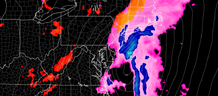
It looks like this handoff/alley-oop of upper level energy will form a surface low near New Orleans on Friday morning. Overrunning precipitation from this low could begin falling as rain in New Jersey as early as noon on Friday. Given the low positioning and temperature profile, I do not expect any kind of changeover to snow until Saturday morning.
The surface low is modeled, almost unanimously, to track over the SE US and eject into the Atlantic Ocean near the Virginia/North Carolina border latitude. This is just a hair too far N for a widespread NJ snowstorm. If the low were to CONTINUE its SE trend towards a solution that ejects over OBX, instead of the VA/NC border, then we could be looking at a snowier outcome for more parts of NJ. I will be monitoring this closely in the next few days.
However, right now NJ is looking at rain starting as early as noon on Friday, lasting overnight into Saturday morning, and then possibly changing to snow for NNJ and WCNJ as it wraps up by noon on Saturday. To be clear, I am seeing a rain-to-snow situation for parts of NNJ/WCNJ right now. This is the wintry storm signal that I’ve been following since last Wednesday when I recognized and “liked” the pattern for potential snow. This does however mean that SNJ is currently modeled too warm to end as snow.
So, I am going to watch the model guidance come in overnight tonight and tomorrow before jumping to any conclusions or certain forecasts. But it does look like this Friday-Saturday’s system could potentially produce snow for NNJ/CNJ this coming Saturday morning. The Euro is suggesting as much as 2-4 inches of snow falling in NNJ and E parts of CNJ before the system wraps up on Saturday around noon. The GFS has the storm and positioning but less wintry mix on the backside. Like I said, let’s see where the guidance gravitates over the next 24 hours before making any kind of forecast.
In English: Per the latest model data, rain could start this Friday (around noon) and end as snow this Saturday morning (7am to noon). A few inches are theoretically possible for NNJ and ECNJ by the time it wraps up on Saturday. The general pattern supports it and it could trend towards an even colder solution as we closer approach. I’ll be watching. Either way, this Friday at noon to Saturday at noon looks like a period of precipitation and wind. I’ll be watching and will report more tomorrow afternoon. Have a great rest of your Wednesday and please be safe! JC
Download the free Weather NJ mobile app on Apple or Android. It’s the easiest way to never miss Weather NJ content. Our premium services go even further above and beyond at the hyper-local level. Get your merch on at the KABOOM shop in time for the holidays.
Jonathan Carr (JC) is the founder and sole operator of Weather NJ, New Jersey’s largest independent weather reporting agency. Since 2010, Jonathan has provided weather safety discussion and forecasting services for New Jersey and surrounding areas through the web and social media. Originally branded as Severe NJ Weather (before 2014), Weather NJ is proud to bring you accurate and responsible forecast discussion ahead of high-stakes weather scenarios that impact this great garden state of ours. All Weather. All New Jersey.™ Be safe! JC


LOCAL FORECAST | INTERACTIVE RADAR | LATEST NJ WEATHER ALERTS | WEDDING FORECAST| PRIVACY POLICY
© Copyright 2026 Weather NJ LLC. All Rights Reserved.
Some information that can be found on our website is provided by a private weather station and is not an officially recognized station for weather reporting. Though we always strive to achieve accurate reporting for our own use, it is important that you do NOT depend on the data provided here for any purpose.
