

Feb 6: Thursday Snow Update Video
Support is increasing for significant snowfall through New Jersey this Wed PM-Thurs AM. Here are my updated thoughts…
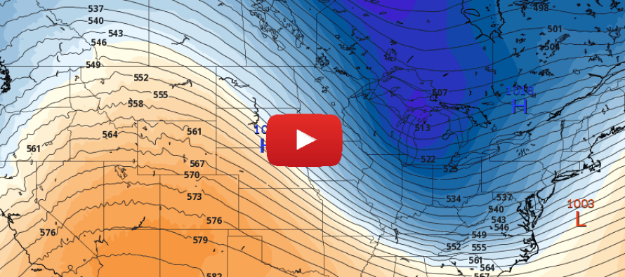
Text version of video: The timing of this system is much easier to grasp than the final storm track. We’ve always been looking at a system where precipitation arrives as early as late Wednesday night and clears out by Thursday afternoon (if not by late morning). As far as storm track, there’s still some play which is not uncommon from this forecasting range (about 60 hours out). However the spread of possibilities is narrowing down some.
Obviously the main concern with this system will be the setup location of the jackpot zone (where the heaviest snowfall will occur and stick). Right now, the modeled track deviation is spraying that jackpot zone axis NW and SE parallel to the I-95 corridor. The Euro and its ensemble members favor this jackpot to occur along and SE of the I-95 corridor. The GFS is suggesting this to occur along and NW of the I-95 corridor. But either way, the jackpot axis appears to run through New Jersey.
How much will fall in the jackpot zone? It’s not that simple yet. This is a rain-to-snow event. When it begins, I would expect extreme NNJ to be the only area capable of starting as snow. The rest of the state would likely start as rain. This snow/rain line would then move from NW to SE through the storm as rain changes over to snow with a brief period of sleet possible between. If the temps crash to the coast faster, then accumulations will perform on the higher side, possibly as a significant-to-major event. If the temps do not crash as fast then accumulations then some areas might never go over to snow. The greatest chance for that would obviously be the immediate SENJ coast and you would then decrease in chance as you moved away from the coast to the NE. There are a lot of factors that could go either way (warmer or colder) for the surface to 925mb layer so that’s something I’ll be watching. We’re cold from 850mb and above though so little to no snow inhibition aloft.
So confidence in timing is fairly high. Which part of NJ gets hit is still yet to be determined. It does however appear that 1/3 to 1/2 of the state (just going by surface area) is subject to a significant winter storm. I don’t strong support for double-digits just yet…only a small wildcard over-performance possibility which is not enough to back a forecast IMO. That’s where I’m at right now and we’ll cross that bridge if this starts to look more major tomorrow.
In English: A significant winter storm is gaining support for late Wednesday night through most of Thursday morning. Someone in NJ is likely going to see school closing/plowable snow while surrounding areas to the N and S see lesser impacts. I’m not confident in making that exact assessment as of right now. I need one more day of model data to compare with real-time observations in the W US before making that call. We’ll have an impact map with expected accumulation amounts posted tomorrow evening. My Pocket Meteorologist customers will receive another round of alerts tomorrow afternoon with detailed hyper-local information immediately after we review the 12Z model suite. Those alerts will continue through the entire system as needed. I’ll then need until early evening to help make the snow map and make another video. We’re almost there. Thanks for your patience and understanding. Have a great night and please be safe! JC
Jonathan Carr (JC) is the founder and sole operator of Weather NJ, New Jersey’s largest independent weather reporting agency. Since 2010, Jonathan has provided weather safety discussion and forecasting services for New Jersey and surrounding areas through the web and social media. Originally branded as Severe NJ Weather (before 2014), Weather NJ is proud to bring you accurate and responsible forecast discussion ahead of high-stakes weather scenarios that impact this great garden state of ours. All Weather. All New Jersey.™ Be safe! JC


LOCAL FORECAST | INTERACTIVE RADAR | LATEST NJ WEATHER ALERTS | WEDDING FORECAST| PRIVACY POLICY
© Copyright 2026 Weather NJ LLC. All Rights Reserved.
Some information that can be found on our website is provided by a private weather station and is not an officially recognized station for weather reporting. Though we always strive to achieve accurate reporting for our own use, it is important that you do NOT depend on the data provided here for any purpose.
