


Gorgeous October Conditions


Discussion: This week should feature some of the most beautiful October NJ conditions we’ve seen in a while. We’re talking chilly-but-comfortable highs in the 60s, lots of sunshine, and colder overnights where at least the usual colder spots (NNJ elevations and SNJ Pine Barrens) flirt with dropping to freezing temperatures. There’s not much else to say about the sky this week. Enjoy!
Now to address the offshore ocean low. I’m going to say some things that could be hot takes. But I am going to back up the things I say with sources of evidence. I don’t believe what has formed off the SE US, over the last 24-48 hours, is a nor’easter. This low formed 500 miles offshore and will come nowhere near any of the E US coastline. According to the National Weather Service, a nor’easter forms between Georgia and NJ latitude within 100 miles of the coast. I think some pro forecasters (private and public sector) jumped the gun a bit when models were bringing it closer to the Mid-Atlantic US coast. But that idea fell apart and the low will come nowhere near 100 miles from the coast. Again, for this reason, I am calling it an offshore ocean storm, too far away to be categorized as a nor’easter. There’s going to be anomalously high ridging across the US/Canadian border that will not allow this storm to hit NJ with its core.
There is certainly a low out there but that low alone, will not be bringing primary impacts to the EC. Instead, what’s happening is high pressure is aligning with low pressure in a way that sends strong NE winds towards the OBX area by way of a pressure gradient squeeze. In other words, the NE winds are a product of two different players, one 500 miles offshore and the other over W New England. This image illustrates it:
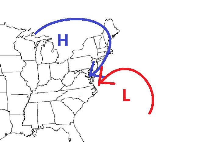
What’s more interesting to me is the subtropical cyclone characteristics developing. They could actually name this thing Josephine if said characteristics (no fronts, temp above 69F) continue development. Now that I’ve said my piece about low classification, let’s talk about impacts regardless of surge source. The pressure gradient squeeze above will produce much worse conditions for OBX/S Delmarva because there’s nothing to shelter the coast from the NE flow. NJ will see more of a N/NE wind direction since it’s so far to the W of the low. This will mitigate ECNJ/SENJ coastal flooding surge to just the minor category (1-2 feet above normal high tide) since the wind direction will be more parallel to the coast/perpendicular to the inlets. That said, ECNJ/SENJ coasts should expect some breezy N/NE winds, no rain, and several days of minor coastal flooding possible to open up the week. Bottom Line: A nor’easter is not coming for New Jersey, but there’s still a NE wind component capable of producing minor coastal flooding and beach erosion Monday-Wednesday. Outside of the minor coastal flooding and some breezy N/NE winds, this week is aces!
Forecast
Monday (Oct 19) high temperatures should reach the mid-60s for most NJ areas with a mix of more sun than clouds. Winds should be light-to-breezy out of the NE away from the ocean. Right along the ocean, winds should sustain 10-20mph with gusts to 35mph out of the N/NE. Minor coastal flooding is possible for ECNJ/SENJ. Overnight lows should range from 35-50 NNJ elevations to SNJ coasts.
Tuesday (Oct 20) high temperatures should reach the mid-to-upper 60s for most NJ areas. Skies should range from clear and sunny in NWNJ to cloudy along the SENJ coast. Rain is expected to stay out to sea with the offshore ocean low. Winds should be light-to-breezy out of the NE away from the ocean. Right along the ocean, winds should sustain 10-20mph with gusts to 35mph out of the N/NE. Minor coastal flooding is possible for ECNJ/SENJ. Overnight lows should range from 35-50 NNJ elevations to SNJ coasts.
Wednesday (Oct 21) high temperatures should reach the low-to-mid 60s for most NJ areas. Skies should be mixed with sun and clouds. Winds should be light-to-breezy out of the N/NE. Overnight lows should range from 34-59 NNJ elevations to SNJ coasts.
Thursday (Oct 22) high temperatures should reach the mid-to-upper 60s for most NJ locations. Skies should be mostly sunny. Winds should be light-to-breezy out of the NW. Overnight lows could flirt with 32 in the usual spots (NNJ elevations and Pine Barrens) while hovering closer to 50 along the coast. Most areas down to the 36-44 range.
Friday (Oct 23) high temperatures should only reach the 55-60 range. Skies should be mostly sunny. Winds should be light-to-breezy out of the N/NW. Overnight lows should fall into the 30s for most NJ areas and possibly below-freezing for the usuals.
An early look at the weekend (Oct 24-25) indicates more of the same. Clear sunny skies during the day and optimal star gazing skies at night. Chilly afternoon highs near-60 and colder overnights in the 30s/40s. Have a great week and please be safe! JC
Premium Services
KABOOM Club offers an ad-free environment, inside info (Above and Beyond) forecast discussion, your questions prioritized, and early storm impact maps and video releases (ahead of the public). At $1.99 per month, it’s an extremely feasible way to show additional support for Weather NJ and you can turn it on and off for however many months you wish. Think of it as a tip jar with perks. Available onFacebook or Patreon.
My Pocket Meteorologist (MPM), in partnership with EPAWA Weather Consulting, offers professional/commercial interests, whose businesses depend on outdoor weather conditions (snow plowing, landscaping, construction, etc.), with hyper-local text message alerts/forecasts from real meteorologists and access to the MPM premium forum—the most comprehensive and technical forecast discussion available for PA and NJ commercial interests.
KABOOM Shop is live if you want some KABOOM or Weather NJ Merch!

Jonathan Carr (JC) is the founder and sole operator of Weather NJ, New Jersey’s largest independent weather reporting agency. Since 2010, Jonathan has provided weather safety discussion and forecasting services for New Jersey and surrounding areas through the web and social media. Originally branded as Severe NJ Weather (before 2014), Weather NJ is proud to bring you accurate and responsible forecast discussion ahead of high-stakes weather scenarios that impact this great garden state of ours. All Weather. All New Jersey.™ Be safe! JC



LOCAL FORECAST | INTERACTIVE RADAR | LATEST NJ WEATHER ALERTS | WEDDING FORECAST| PRIVACY POLICY
© Copyright 2026 Weather NJ LLC. All Rights Reserved.
Some information that can be found on our website is provided by a private weather station and is not an officially recognized station for weather reporting. Though we always strive to achieve accurate reporting for our own use, it is important that you do NOT depend on the data provided here for any purpose.

