

Jan 24: Rainstorm Approaching
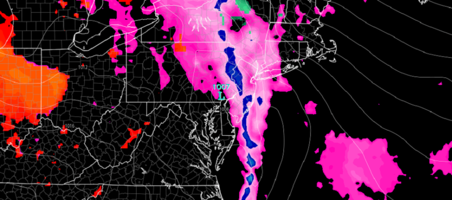
Discussion: Our Upper-Level Low (ULL) is currently centered over S Missouri and should track just to our NW (over the SE Great Lakes) between now and Sunday night. The primary surface low will remain stacked under the ULL over the lakes but a secondary surface low will try to form in the area of greatest Positive Vorticity Advection (PVA) which happens to be inside/near the greatest slug of precipitation over NJ tomorrow (Saturday). For this reason (a lifting trigger within the greatest convection) I believe embedded thunderstorms are possible, but not guaranteed, during the heaviest rainfall Saturday. Such embedded thunderstorms could mean increased wind gust values within an already windy (out of the S/SW) environment. Something we’ll have to watch.
We will have a colder surface air mass over the NWNJ elevations tonight and that could lead to delayed warming tomorrow upon initial precipitation. For that reason there exists the chance for freezing rain tomorrow morning N of I-80/NW of I-287 especially in the higher elevations of Sussex County. For everyone else we are still expecting a general rain-only event with anywhere from .75 to 1.5 inches of rain possible. And once the NWNJ elevation surface profile warms above freezing it will be all rain for all NJ. Our ice and rain impact maps from yesterday will remain valid today as we see no reason for change.
Surface winds are currently out of the E thanks to return flow of high pressure tracking away to our NE. Onshore winds should intensify tomorrow morning with the approaching surface low and remain stiff off the ocean until about early tomorrow (Saturday) afternoon. This should result in a minor risk of coastal flooding, possibly moderate in local instances, for the two high tides that occur on Saturday. Once the surface low passes through NJ longitude and latitude (by Saturday afternoon) winds will switch to the NW which will aid in pushing water back out into the ocean. The pattern then looks cold (not bitter cold) and tranquil from Sunday through most of next week which brings us to next weekend.
Look I understand snow lovers are frustrated with Winter 2019-2020 so far. It’s a nine-inning ballgame however that starts ~Thanksgiving weekend and ends by end of March. That means we’re in the bottom of the 4th with a lot of game left to play. We can conclude that the first 4 innings were mostly mild with few snow chances but we cannot apply that historical sequence to the future. In this game even the most scholarly long-range analysis falls victim to the natural order of chaos that is the atmosphere. To play this game you need to take every 7-10 days at a time. After almost 10 years of doing this I can safely say that every 7-10 day period consistently will hand you something new and not formerly-referenced. If you’re the fan that leaves in the bottom of the 4th because your team is down a few runs then so be it. I like to stay until the end of the game and hope for the best with each at-bat. My point…there are a of at-bats left between now and whenever the snow season shuts off some time in March. Yeah I know there’s been anomalous April snow before but most snow seasons end in mid-to-late March.
Superbowl Weekend, Groundhog Day weekend, however you want to label it has a strong synoptic storm signal showing. That means that there’s a strong chance of a low off the E US that will bring precipitation to New Jersey whether rain or snow. And that’s about the most confident statement you can make at this time. Surface model output will vary with each run from now until then. You might see a Great Lakes Cutter (GLG) like on today’s GFS or you might see a major snowstorm hit like on today’s European model run. I’m much more interested in the consistency of the storm signal’s modeling than I am with the surface model output. On Monday if this signal is still screaming we can start to address the expected surface output. For now there’s a signal on most model guidance (global operationals and ensembles) that something is going to happen. It’s a Miller-A signal which means the surface low originates near/in the Gulf of Mexico and then tracks up the E US coast. It would be the first of the season and these tend to be easier to work with than Miller-B transfers. I’m very interested in this signal and will aggressively monitor between now and Monday. I might touch on it again in Sunday’s Monday-Friday Outlook but I’ll still likely wait until Monday to start sounding alarms. And if the signal drops off then we end our discussion before moving into forecasting mode. For your own preparation and safety awareness just know that some kind of disturbance is strongly modeled in the long range for next weekend. It may drop off. It may hit. Again we won’t be making any sort of definitive statements until Monday at the earliest.
In English: Moderate-to-heavy rainfall will push through New Jersey between Saturday morning and afternoon (tomorrow). NWNJ elevations could start slippery if the ground is still below freezing tomorrow morning. But all areas will eventually warm up. Rainfall could produce flash flooding and possibly contain embedded thunderstorms within. That would mean gusty winds. Winds are already expected to gust to 40mph+. Embedded thunderstorms could mean 50-60mph. Ocean-facing coasts of ECNJ and SENJ could see minor-to-moderate coastal flooding from the intensified onshore winds. It should all push out by late-afternoon Saturday. We then sit in a cold, but not bitter cold, pattern (avg to slightly-above avg temps) next week ahead of a possible larger winter storm next weekend. I’ll be watching next weekend’s storm modeling this weekend and will report back on Sunday for the Monday-Friday outlook. Everyone have a great weekend and please be safe! JC
Download the new free Weather NJ mobile app on Apple and/or Android. It’s the easiest way to never miss Weather NJ content. Our premium services go even further above and beyond at the hyper-local level. Looking for industrial-caliber long-range forecasting data that I personally recommend? Check out WeatherTrends360! Visit the Weather NJ Kaboom Shop for hoodies, tees and infant onesies.
Jonathan Carr (JC) is the founder and sole operator of Weather NJ, New Jersey’s largest independent weather reporting agency. Since 2010, Jonathan has provided weather safety discussion and forecasting services for New Jersey and surrounding areas through the web and social media. Originally branded as Severe NJ Weather (before 2014), Weather NJ is proud to bring you accurate and responsible forecast discussion ahead of high-stakes weather scenarios that impact this great garden state of ours. All Weather. All New Jersey.™ Be safe! JC


LOCAL FORECAST | INTERACTIVE RADAR | LATEST NJ WEATHER ALERTS | WEDDING FORECAST| PRIVACY POLICY
© Copyright 2025 Weather NJ LLC. All Rights Reserved.
Some information that can be found on our website is provided by a private weather station and is not an officially recognized station for weather reporting. Though we always strive to achieve accurate reporting for our own use, it is important that you do NOT depend on the data provided here for any purpose.
