

Jan 9: Icing Possible for Points NW
Most of New Jersey will warm up and rain Tuesday PM into Wednesday AM. Some areas could ice up however. Let’s break it down…
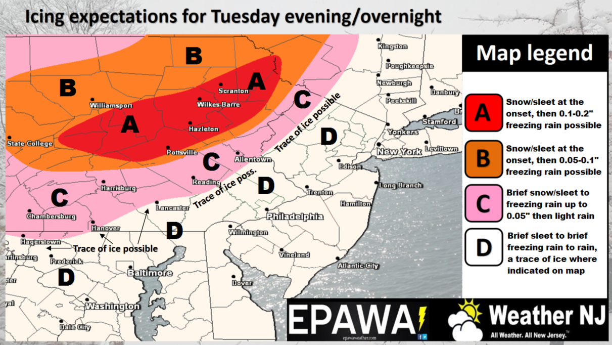
Click here to view full resolution impact map.
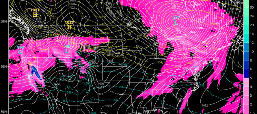
Disco: The same high pressure that reinforced the current colder Arctic air mass is sliding into the Atlantic Ocean, just to the S of New Jersey. This will change the flow over NJ from northerly to southerly winds. This return flow is already somewhat evident today but will be much more noticeable on Tuesday as high temperatures surge above freezing. While it won’t be beach weather, it will feel very mild relative to what we’ve gotten used to over the last few days.
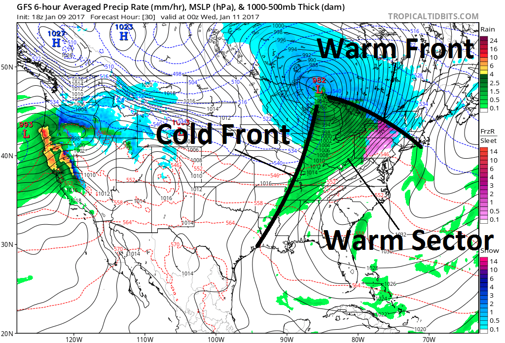
We then have a low pressure system tracking far to our NW into Canada Tuesday into Wednesday. This will first drag a warm front through our region later Tuesday night from S to N. Then we will be warm-sectored Tuesday night through Wednesday morning. Lastly, a cold front will move through from W to E by late Wednesday AM/early Wednesday afternoon as shown below:
Precipitation chances exist for all three mentioned components (warm front, warm sector and cold front). The initial precipitation that moves in Tuesday night however might present some wintry concerns, especially at the surface. Most of New Jersey should quickly go over to all rain given the stronger aforementioned southerly flow working all day on Tuesday. NWNJ elevations however could hold onto some of the cold. This could mean a mix of snow/sleet and/or freezing rain, primarily for the elevations of Sussex and Warren Counties but also possible at elevation bases in NNJ. Accumulations are not expected but obviously wintry precip could slick up the roads a bit before changing to all rain over a +32F surface. My gut here is that freezing rain would be the most probable precipitation type. At this time there is little wintry concern for the lower 2/3 of New Jersey, especially the coast. So possible icing for NWNJ to start before changing to rain. Mostly all rain for everyone else in NJ.
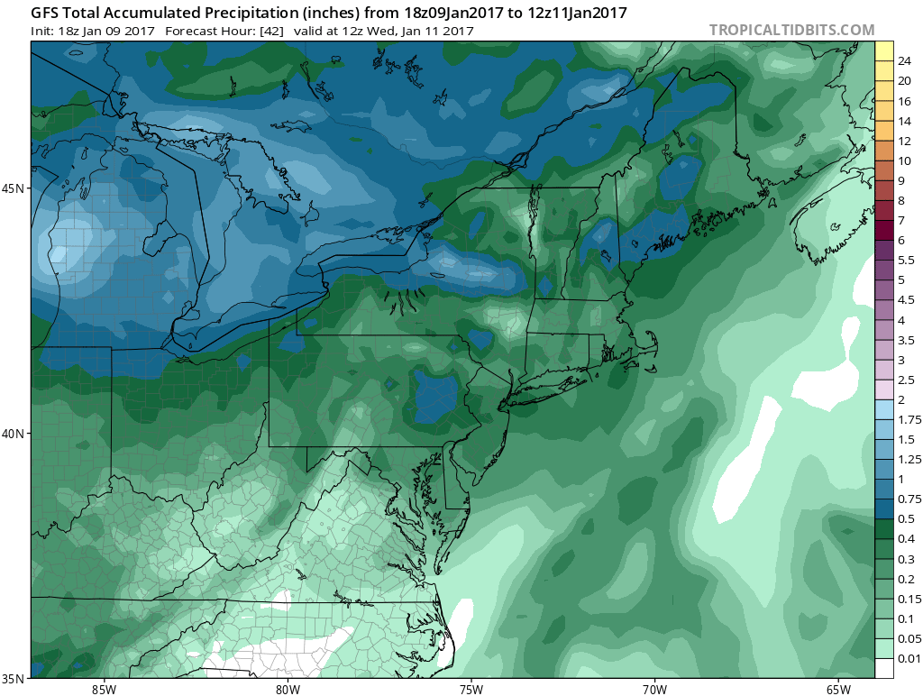
I do have a few additional concerns. First is flash flooding. While Tuesday’s warmer temperatures and southerly flow should melt a lot of snow, there is still a healthy snow pack for SENJ areas that jackpotted on Saturday. Flash flooding would be a concern for any areas that still have a few inches of snow on the ground. Such would be localized and isolated and will trigger a flash flood warning by the NWS if need be. However, if most snow in SENJ is melted by sunset tomorrow then there should be little concern. Also this shouldn’t be too bad of an issue considering the low total amount of expected precipitation which is less than a half-inch statewide:
Second and more important to NJ is fog. We’re going to have warm and moist air surging into the backside of this current cold air mass. Therefore fog could limit visibility to under 1/4 mile at times from Tuesday night through Wednesday.
In English: We’re cold again tonight. Watch out for freezing fog should temps and dew points meet in the middle below freezing. I could see the SNJ pine barrens having the greatest chance for that before sunrise tomorrow morning. Tomorrow we moderate ahead of a mostly rain event tomorrow night through Wednesday AM. NWNJ could start as wintry precipitation overnight (primarily as freezing rain) but everyone ends as plain rain by late Wednesday morning. I’ll have an update about the weekend tomorrow night. It’s still looking like a strong high to our north forcing just enough cold southward to possibly drop some more wintry precipitation across parts of NJ. Be safe! JC
Jonathan Carr (JC) is the founder and sole operator of Weather NJ, New Jersey’s largest independent weather reporting agency. Since 2010, Jonathan has provided weather safety discussion and forecasting services for New Jersey and surrounding areas through the web and social media. Originally branded as Severe NJ Weather (before 2014), Weather NJ is proud to bring you accurate and responsible forecast discussion ahead of high-stakes weather scenarios that impact this great garden state of ours. All Weather. All New Jersey.™ Be safe! JC


LOCAL FORECAST | INTERACTIVE RADAR | LATEST NJ WEATHER ALERTS | WEDDING FORECAST| PRIVACY POLICY
© Copyright 2026 Weather NJ LLC. All Rights Reserved.
Some information that can be found on our website is provided by a private weather station and is not an officially recognized station for weather reporting. Though we always strive to achieve accurate reporting for our own use, it is important that you do NOT depend on the data provided here for any purpose.
