


Nor’easter Approaching

Discussion
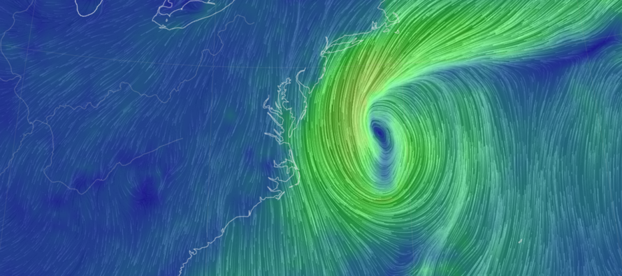
Models have trended even more towards a harder New Jersey hit from this weekend’s nor’easter. Here are the updated rain, wind and coastal flooding impacts with graphics and text:
Hazardous Impacts
Rain
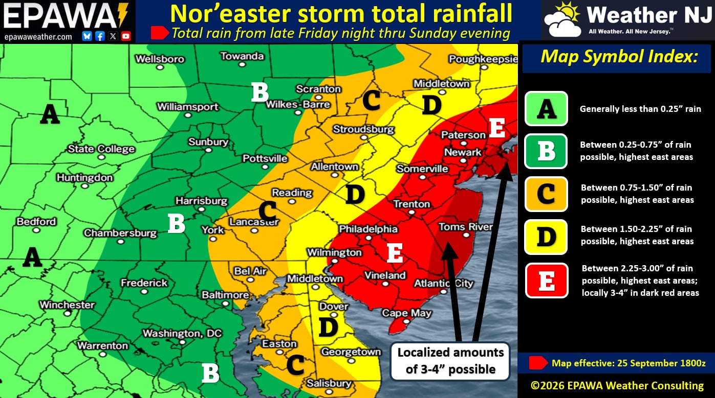
The storm’s outer precipitation bands are nearing the Jersey shore but still have some time before pushing onto land. I expect that to happen by late tonight/NLT early Saturday am hours. It will then rain through Saturday and most of Sunday (hard at times), possibly most of Monday (lighter) before tapering off slowly from W to E Monday PM/Tuesday AM. As indicated by our rain map, areas of closer proximity to the nor’easter will see greater rainfall amounts. Here are the total expected rainfall amounts:
Wind
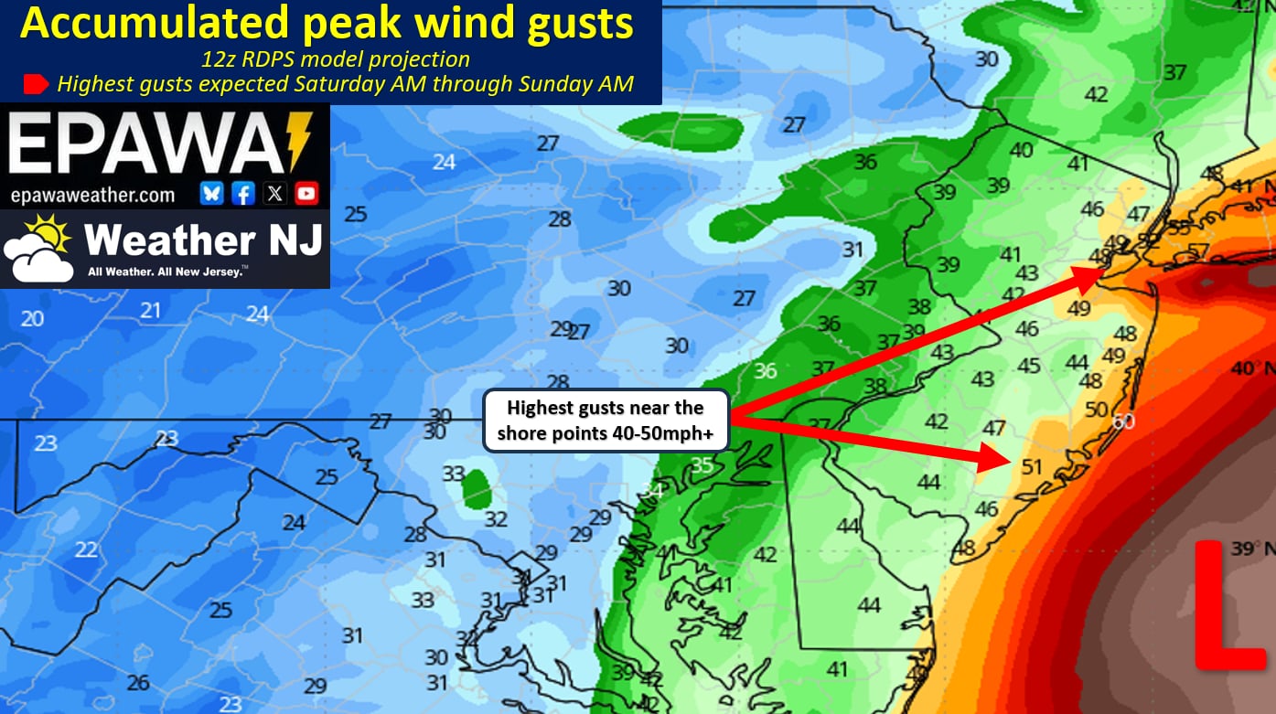
Winds have been holding stiff over the past 24 hours…mostly in the 25-35mph range along the coast and less away from the ocean. Winds will increase tonight and peak from Saturday AM through Sunday AM before winding down Sunday night into Monday. Wind direction tonight and Saturday morning are onshore (E/NE or NE). Wind direction will then change to N/NE and eventually N Saturday night into Sunday morning. We’ll actually see N/NW winds as the system departs Sunday night into Monday. The greatest wind gusts are expected between Saturday morning and Sunday morning. During this time we anticipate winds gusting to ~40, maybe 45mph away from the ocean (all of NJ less the coast). Immediate coastal areas will take the hardest winds to the face. This is coastal Monmouth, Ocean, Burlington and Cape May Counties. Here, we anticipate wind gusts to 60mph. I honestly would not be surprised if a few spots hit 70mph, especially if the low pressure drops below 980mb. Here is our wind map, derived from the RRFS:
Coastal Flooding
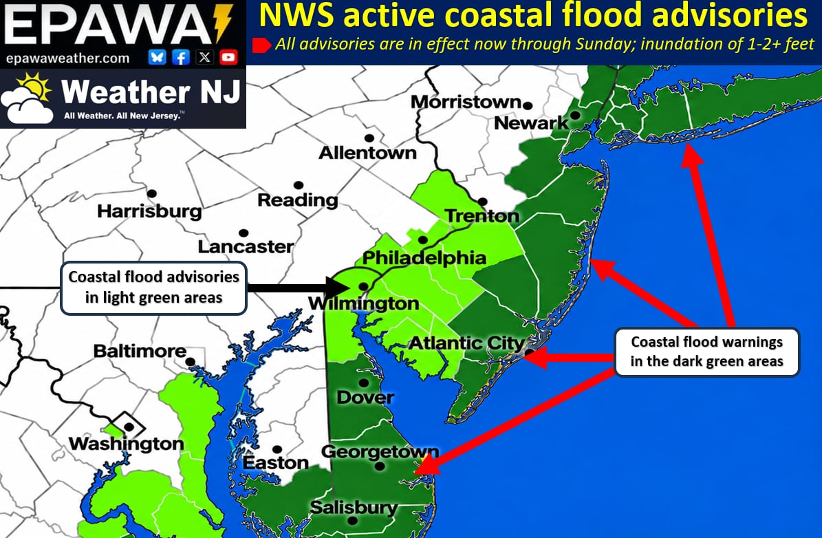
Right now, every ENJ county is under a coastal flood warning from the National Weather Service and for good reason. Full moon Saturday, inches of rainfall with nowhere to drain, prolonged fetch of onshore flow (started earlier this week and will lead right into the main event). Coastal flooding is again, still the headliner IMO. The two worst high tides will be tonight (Friday night ~10pm) and tomorrow (Saturday morning ~930am). The third high tide on Saturday night ~9pm could be a close third. The remaining Sunday Monday and Tuesday tides will all still be elevated but each tidal cycle will subside to eventually reach average levels by Tuesday. My gut feel, I’ve had all week, of major coastal flooding remains firm. Will the coastal flooding be as bad as Sandy? Probably not. Could it come close for some coastal areas? Small possibility, but non-zero. Even if it doesn’t that’s still a serious coastal flooding event folks! I’m honestly surprised there hasn’t been at least voluntary evacuation talk. If it was me, I’d get off the barrier islands for a few days. If not, I’d want to be in a house on pilings with a higher place to park the car. Here is a map represented the current NWS coastal flooding warnings:
In English
The above-described hazards are broken down mostly in English. Similar forecast as yesterday’s update but slightly more aggressive on the coastal flooding part of the storm. Expect widespread power outages for ENJ/SENJ and likely isolated-to-scattered power outages for WNJ. The combination of coastal flooding and winds should produce serious beach erosion. At the end of the day, a long rain and wind storm away from the ocean that we’ve seen many times before. But for the coast, possibly a historic coastal flooding event…likely falling short of Sandy, 1962, 1944 but possibly as historic as some other great nor’easters. Another YouTube video tonight and then we enter real-time tracking. Have a great Friday evening and please be safe! JC
Premium Services
KABOOM Club offers an ad-free environment, inside info (Above and Beyond) forecast discussion, your questions prioritized, and early storm impact maps and video releases (ahead of the public). At $1.99 per month, it’s an extremely feasible way to show additional support for Weather NJ and you can turn it on and off for however many months you wish. Think of it as a tip jar with perks. Available on Facebook or Patreon.
My Pocket Meteorologist (MPM), in partnership with EPAWA Weather Consulting, offers professional/commercial interests, whose businesses depend on outdoor weather conditions (snow plowing, landscaping, construction, etc.), with hyper-local text message alerts/forecasts from real meteorologists and access to the MPM premium forum—the most comprehensive and technical forecast discussion available for PA and NJ commercial interests.
KABOOM Shop is live if you want some KABOOM or Weather NJ Merch!

Jonathan Carr (JC) is the founder and sole operator of Weather NJ, New Jersey’s largest independent weather reporting agency. Since 2010, Jonathan has provided weather safety discussion and forecasting services for New Jersey and surrounding areas through the web and social media. Originally branded as Severe NJ Weather (before 2014), Weather NJ is proud to bring you accurate and responsible forecast discussion ahead of high-stakes weather scenarios that impact this great garden state of ours. All Weather. All New Jersey.™ Be safe! JC



LOCAL FORECAST | INTERACTIVE RADAR | LATEST NJ WEATHER ALERTS | WEDDING FORECAST| PRIVACY POLICY
© Copyright 2026 Weather NJ LLC. All Rights Reserved.
Some information that can be found on our website is provided by a private weather station and is not an officially recognized station for weather reporting. Though we always strive to achieve accurate reporting for our own use, it is important that you do NOT depend on the data provided here for any purpose.

