


Nor’easter Developing

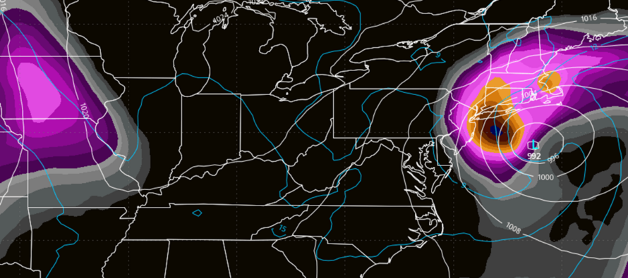
Discussion: Model guidance remains split on the track of this weekend’s nor’easter. I am however giving it a go as in, it’s happening. The energy has been coming together off the SE US for a day or two now and with the blocking developing to the N and E of NJ, I think we’re at least going to feel some level of impact from the nor’easter. Let’s look at where the goalposts are at this point. We have two scenarios IMO:
Scenario 1: Nor’easter takes more of an offshore track (like the GFS and GFS AI). Rain: Maybe a half-inch to an inch and heavily favoring SENJ over the rest of NJ. Won’t fall in a short amount of time which mitigates flash flooding potential. There’s a small chance the rain stays offshore completely in this scenario…maybe more of a misting. Wind: Nothing we haven’t seen many times before in run-of-mill coastal storms…sustained 15-25mph with gusts to 30-40mph. Coastal flooding: Still some concern given the offshore wind dynamics and how this week is locking in onshore flow from the elongated high in Canada. Add in the full moon. So, even if the low misses NJ directly and hits more towards Cape Cod, I think minor-to-moderate coastal flooding is still on the table. Timing: Rain, if any even makes it into coast, could hold off as late as Saturday evening and possibly in the form of an inverted trough wrapping around a looping low. Winds and coastal flooding would build up significantly Friday into Saturday. Conditions would begin improving Sunday afternoon and clear out by Sunday night/early morning.
Scenario 2: Nor’easter hits NJ directly (like the Euro and Euro AI). Rain: 2-3 inches possible over the entire duration of storm and for most of NJ maybe less extreme NWNJ elevations and PA-bordering WNJ. Flash flooding still mitigated from the rainfall quantity spread out over 24+ hours. Wind: It’ll be rocking but we’ve seen it before…sustained 20-25mph with gusts to 45-55mph. Coastal Flooding: This is where the storm would sting most IMO. A track like the Euro pins NJ under onshore flow (E/NE to NE to N/NE) for a 24 hour period. With the full moon, I would expect moderate-to-major levels of coastal flooding. Timing: Rain would arrive earlier in this case, starting as early as Friday night and not tapering off until well into Monday. Winds would ramp up Friday, crank their hardest Saturday into Sunday and then wind down as northerly winds Sunday night into Monday.
We need another 24-hour set of evolving model guidance to start matching up with live observations before we can forecast a more specific track. The blocking influence will have the greatest impact on whether the storm veers into NJ after getting stuck under it…or stays offshore if the blocking is weaker. But at this point, I am leaning towards something between the two scenarios above. In either case, we’ve seen this kind of rain and wind many times before. Power outages more isolated/scattered than widespread and focused on the ECNJ/SENJ/SNJ coasts. The coastal flooding element however could range from something we’ve seen many times before (GFS solution) to a more serious evacuation of barrier islands and tidal communities type event (possible if Euro solution verifies).
In English: There is still a lot of uncertainty as to whether this weekend’s nor’easter will track 100-200 miles offshore (like the Euro is showing) or more like 200-400 miles offshore (like the GFS is showing). The former brings inches of rain (Friday-Monday), wind gusts 50+ mph and a possible serious coastal flooding event. The latter brings less rain, possibly none, to NJ (Saturday-Sunday), wind gusts likely capped at 40mph along the coast (less inland) and run-of-mill coastal flooding to places that typically flood. But, I think we are down to this spread of possibilities regardless of track. The next 24 hours will be all about narrowing these possibilities tighter into a more practical forecast expectation. For now, this weekend will likely play out somewhere between the two. Best I can do for now. If you live along the immediate coast or in a community prone to coastal flooding, you should have a plan just in case evacuations are called. With something like this, I would lean more towards voluntary evacuation rather than mandatory evacuation. And that’s only in the case of a direct hit like the Euro. Something in-between not likely to cause evacuations. At the very least, have a plan to get your vehicles higher, expect power outages, etc. We’ve been down this road before. Tomorrow I will likely release another update article like this earlier in the day with a YouTube video in the evening. Time to dust that stuff off for winter anyway. Hope you are enjoying the colder fall conditions. Have a great rest of your Wednesday night and please be safe! JC
Premium Services
KABOOM Club offers an ad-free environment, inside info (Above and Beyond) forecast discussion, your questions prioritized, and early storm impact maps and video releases (ahead of the public). At $1.99 per month, it’s an extremely feasible way to show additional support for Weather NJ and you can turn it on and off for however many months you wish. Think of it as a tip jar with perks. Available onFacebook or Patreon.
My Pocket Meteorologist (MPM), in partnership with EPAWA Weather Consulting, offers professional/commercial interests, whose businesses depend on outdoor weather conditions (snow plowing, landscaping, construction, etc.), with hyper-local text message alerts/forecasts from real meteorologists and access to the MPM premium forum—the most comprehensive and technical forecast discussion available for PA and NJ commercial interests.
KABOOM Shop is live if you want some KABOOM or Weather NJ Merch!

Jonathan Carr (JC) is the founder and sole operator of Weather NJ, New Jersey’s largest independent weather reporting agency. Since 2010, Jonathan has provided weather safety discussion and forecasting services for New Jersey and surrounding areas through the web and social media. Originally branded as Severe NJ Weather (before 2014), Weather NJ is proud to bring you accurate and responsible forecast discussion ahead of high-stakes weather scenarios that impact this great garden state of ours. All Weather. All New Jersey.™ Be safe! JC



LOCAL FORECAST | INTERACTIVE RADAR | LATEST NJ WEATHER ALERTS | WEDDING FORECAST| PRIVACY POLICY
© Copyright 2026 Weather NJ LLC. All Rights Reserved.
Some information that can be found on our website is provided by a private weather station and is not an officially recognized station for weather reporting. Though we always strive to achieve accurate reporting for our own use, it is important that you do NOT depend on the data provided here for any purpose.

