

Nov 20: Massive Great Lakes Storm Expected!
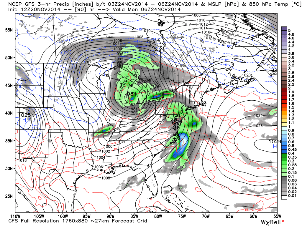
After high pressure moves through the region this Saturday-Sunday, a powerful low pressure system will form in Texas and rapidly strengthen as it moves towards the Great Lakes. What does that mean for New Jersey? A warm period of southerly flow heading into Thanksgiving with some rain Sunday night-Monday morning! This is the latest GFS showing 850mb pressure, temperature, and precipitation between 7PM Sunday evening and 1AM Monday morning. Notice the low down to 981mb and centered over Michigan? This will be rain for everyone including the areas recently hit by lake effect snow. That’s a healthy batch of precipitation moving up the coast along the eastern side of it’s cyclonic flow:
In English: Temperatures should dip below freezing tonight and max out in the 30s tomorrow afternoon. A strong storm will hit the Great Lakes over the weekend and pull rain and warmth up the coast. While its raining on Monday, temperatures should easily break 60 for coastal/SENJ. Tuesday up to Thanksgiving should then be relatively mild with highs in the upper 40s/low 50s featuring dry and mostly sunny skies. The cold should then return. Be safe! JC
Jonathan Carr (JC) is the founder and sole operator of Weather NJ, New Jersey’s largest independent weather reporting agency. Since 2010, Jonathan has provided weather safety discussion and forecasting services for New Jersey and surrounding areas through the web and social media. Originally branded as Severe NJ Weather (before 2014), Weather NJ is proud to bring you accurate and responsible forecast discussion ahead of high-stakes weather scenarios that impact this great garden state of ours. All Weather. All New Jersey.™ Be safe! JC


LOCAL FORECAST | INTERACTIVE RADAR | LATEST NJ WEATHER ALERTS | WEDDING FORECAST| PRIVACY POLICY
© Copyright 2025 Weather NJ LLC. All Rights Reserved.
Some information that can be found on our website is provided by a private weather station and is not an officially recognized station for weather reporting. Though we always strive to achieve accurate reporting for our own use, it is important that you do NOT depend on the data provided here for any purpose.
