

Oct 3: Coastal Flooding and Beach Erosion Continues
Coastal regions of New Jersey will continue to see above-normal tidal cycles as onshore flow persists. Basically, an area of strong high pressure in Canada (clockwise anti-cyclonic flow in the northern hemisphere) is working with Joaquin’s current position (counter-clockwise cyclonic flow in the northern hemisphere) to squeeze the onshore flow jet into the mid-Atlantic. This will continue to occur until Joaquin swings out to sea around an area of low pressure in South Carolina. It almost looks like a Fijiwhara effect had a kid with an inverted trough. I apologize if that botches the science of it but that’s what it resembles to me.
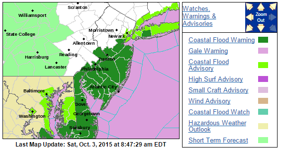
Therefore, I expect tidal cycles to remain high until at least Monday. My favorite place to monitor tide cycles and levels is right here. The link is stationed at Atlantic City but you can change your city. The National Weather Service (Mt. Holly, NJ office) has coastal flood warnings and advisories in effect for a lot of New Jersey:
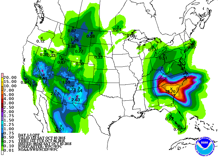
As far as rainfall goes, the NWS Weather Prediction Center (WPC) expects the following additional rainfall before precipitation tapers off between tonight and Sunday morning (a little less than a half-inch for all of NJ):
By Tuesday morning, the onshore flow should subside as high pressure moves in mid-week and gives us cool, crisp and dry air for as far as I can comfortably see in the forecast. Until then, please use caution in coastal regions that are flooding, especially during high tide. Also, please use caution along the beach. Erosion will be pretty substantial with dangerous currents and waves. It is important to note that the current flooding and wind, unfortunate as it is, is not from a land-falling Joaquin. Be safe! JC
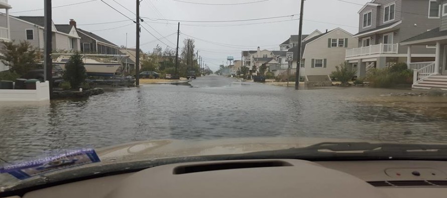
Cover image credit: Shaynna Lynne, taken on 9th street in Surf City, NJ
Jonathan Carr (JC) is the founder and sole operator of Weather NJ, New Jersey’s largest independent weather reporting agency. Since 2010, Jonathan has provided weather safety discussion and forecasting services for New Jersey and surrounding areas through the web and social media. Originally branded as Severe NJ Weather (before 2014), Weather NJ is proud to bring you accurate and responsible forecast discussion ahead of high-stakes weather scenarios that impact this great garden state of ours. All Weather. All New Jersey.™ Be safe! JC


LOCAL FORECAST | INTERACTIVE RADAR | LATEST NJ WEATHER ALERTS | WEDDING FORECAST| PRIVACY POLICY
© Copyright 2026 Weather NJ LLC. All Rights Reserved.
Some information that can be found on our website is provided by a private weather station and is not an officially recognized station for weather reporting. Though we always strive to achieve accurate reporting for our own use, it is important that you do NOT depend on the data provided here for any purpose.
