

Snow is Approaching!

Discussion: First, I must apologize. I just got home from a work trip and I am a bit out of sorts from being unable to stay connected to the latest model guidance and live observations. But here we are now and to the delight of snow lovers, it looks like a little “something-something wintry” is possible tomorrow (Thursday).
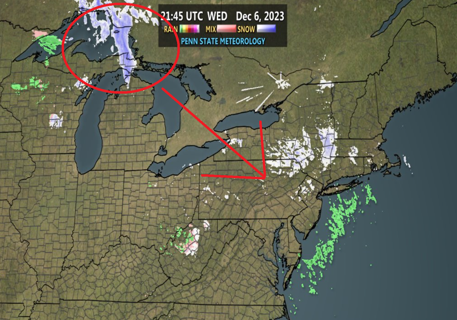
Snow tomorrow (December 7) has actually been a wintry signal for almost two weeks now in one form of another. You might have seen me mention it in last Friday’s weekend outlook. I’m going to credit the GFS model for sniffing it out almost two weeks ago. It originally showed up as a larger synoptic snowstorm about 10 days ago. Then it disappeared on guidance for a few days and then reappeared again this past weekend as an inverted trough. Earlier this week it slipped off guidance with the offshore inverted trough expectation but here we are issuing a light snow event expectation for tomorrow, Thursday, December 7. The inverted trough sort of swung it’s tail through today, which did result in some flurries. But what will actually fall tomorrow is different.
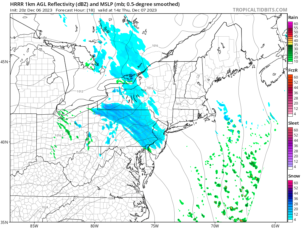
Tomorrow (Thursday, December 7), we’re going to see a very fast moving clipper-like system approach New Jersey from the NW and clear the SENJ coast, likely all before noon. It looks like the main window of light-to-maybe harder snowfall will be between 9am and 1pm overall. Earlier for NWNJ/WNJ and later for ENJ/SENJ. Will it be cold enough aloft to support snow? Yes, no doubt. The lower-mid levels are below freezing and will stay that way through the period of interest tomorrow. Will it stick? There’s a much better chance in NWNJ than SENJ however, surface temperatures should be cold overnight tonight possibly into tomorrow morning. While most short-range model guidance has at least the lower 2/3 of NJ rising above freezing for snow time tomorrow, the models are not factoring in how snowfall can hold the surface colder. Also, sun angle is a non-issue this time of year.
With all of that said, I think many areas of New Jersey are subject to a coating to an inch or two of snow tomorrow between the overall 9am to 1pm window (most occurring just before noon). Once the precipitation ends (by early afternoon at the latest) and the sun is allowed back out, you’ll probably see decent meltage of whatever has fallen. Surface temperatures will want to rise above freezing. And tomorrow’s snow accumulation should do much better on natural surfaces rather than paved/concrete surfaces. But right now, it seems like more than flurries but less than a significant event. We can probably call it a light snow event that is expected with trace-to-light accumulations possible. Here’s some supporting short-range model guidance and live radar observations for tomorrow morning’s event.

I will have to monitor and update accordingly tonight through tomorrow morning with radar obs updates on social media. Let’s get through tomorrow morning and then I’ll put out the weekend outlook either later tomorrow night or Friday morning. But right now Friday-Saturday are still expected to rebound warmer (dry conditions) with a frontal rain system pushing through between Sunday PM and Monday AM. Sunday morning into afternoon might be that warm sector spike period just ahead of the approaching front.
In English: Colder air has settled into the region. Most NJ locations (aside from immediate ECNJ/SENJ coasts) will dip into the 20s tonight (Wednesday night) and stay below freezing through most of Thursday morning. A swath of snow (weak and fast clipper) should push through NJ tomorrow morning from NW to SE and could throw down anything from a coating to an inch or two, mostly on natural surfaces only but possibly some roads. Not a big deal/event but enough to make drivers do their thing when snowflakes are observed LOL. I’m expecting most snowfall to occur between 9am and noon tomorrow (Thursday, December 6), maybe slightly later than noon. Likely not a plowable event. Another conversational light event is the most probable outcome but probably more than just the few flurries we’ve had a couple of times already. I’ll be updating later tonight and tomorrow morning. This forecast goes for the entire state of New Jersey but NWNJ should do better than SENJ given proximity and temperature gradients. Have a great rest of your Wednesday night and please continue to purchase and wear the official inside-out KABOOM pajamas. They’re already working! Be safe! JC
Premium Services
KABOOM Club offers inside info forecast discussion, your questions answered, and early storm impact maps (ahead of the public). At a buck per month, it’s an extremely feasible way to show support.
My Pocket Meteorologist (MPM), in partnership with EPAWA Weather Consulting, offers professional/commercial interests, whose businesses depend on outdoor weather conditions (snow plowing, landscaping, construction, etc.), with hyper-local text message alerts/forecasts and access to the MPM premium forum—the most comprehensive and technical forecast discussion available for PA and NJ.
Jonathan Carr (JC) is the founder and sole operator of Weather NJ, New Jersey’s largest independent weather reporting agency. Since 2010, Jonathan has provided weather safety discussion and forecasting services for New Jersey and surrounding areas through the web and social media. Originally branded as Severe NJ Weather (before 2014), Weather NJ is proud to bring you accurate and responsible forecast discussion ahead of high-stakes weather scenarios that impact this great garden state of ours. All Weather. All New Jersey.™ Be safe! JC


LOCAL FORECAST | INTERACTIVE RADAR | LATEST NJ WEATHER ALERTS | WEDDING FORECAST| PRIVACY POLICY
© Copyright 2026 Weather NJ LLC. All Rights Reserved.
Some information that can be found on our website is provided by a private weather station and is not an officially recognized station for weather reporting. Though we always strive to achieve accurate reporting for our own use, it is important that you do NOT depend on the data provided here for any purpose.
