

The Good Stuff is on the Way
Discussion: For the first half of this week a trough will approach NJ from the W/NW and eventually bring a frontal system through on Wednesday. We’re warm (but not scorching) until then with elevated humidity. Both temps and humidity should take a dive downward behind the Wednesday frontal system. NJ should then see cooler and drier conditions into and through this weekend.
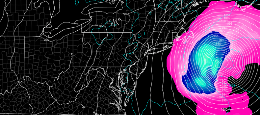
Lee is currently a major category 3 hurricane located N of the Leeward Islands. If you’ve been following my discussions from last week, we still have a few days of slow W/NW movement (part 1) before Lee is expected to turn northward (around Wednesday). Wednesday will begin part 2 where the rounding steering currents of the trough should keep Lee away from NJ in the Wednesday-Friday period. Lee should pass closer to Bermuda than the SE US or Mid-Atlantic US. NJ should be spared primary impacts (destructive winds and dangerous storm surge) however secondary impacts (rip currents, enhanced surf, and minor coastal flooding) are very possible in that Wed-Fri period. Conditions should be very nice for NJ, maybe a little breezy out of the NW but cooler and drier, as Lee passes by. But again, the beaches and ocean could be rough. I am slightly more concerned about part 3 of Lee, not for NJ but for New England. The trough looks quicker (noticeable trend over last few days). Also, Lee seems slightly slower. This could allow Lee to get stuck under a ridge (once the trough and upper low are out) and hook into New England a bit. Anyone from Cape Cod through the Gulf of Maine should be paying attention to this. I really hope that this trend doesn’t continue because if so, then Long Island, possibly even E NYC areas, would have to consider stronger impacts. I still think Lee will make landfall somewhere between the Gulf of Maine and Nova Scotia rather than fully recurving out to sea and avoiding SE Canada altogether. That landfall would likely be from a transitioning Lee into an extra-tropical cyclone. Just like Sandy. So in summary, I still think Lee misses NJ, but roughs up the NJ surf, and could possibly hit somewhere between E Maine and Nova Scotia.
I know it’s a long way away, but long-range model guidance is hinting at a weak tropical storm signal for the Sept 22-24 period. Just something to watch unfold over the next few weeks. Definitely not something to get worked up about from this range. It could easily drop off of model guidance but if not, won’t be taken seriously until probably a week from today.
Monday (Sept 11) high temperatures should reach the upper-70s/lower-80s for most NJ locations. Skies should be mostly cloudy with a humid feel. Showers and thunderstorms are possible with PM hours favored over AM hours. Winds should be light out of the NE. Overnight lows should range from 60-70 from NNJ elevations to SNJ coasts.
Tuesday (Sept 12) high temperatures should reach the low-to-mid 80s for most NJ locations. Skies should be mixed with sun and clouds with a humid feel. Winds should be light out of the S. Overnight lows should range from mid-60s to lower-70s from NNJ elevations to SNJ coasts.
Wednesday (Sept 13) high temperatures should reach the low-to-mid 70s for most NJ locations. A day of transition. Skies should be mixed with more clouds than sun to start. But as conditions improve towards evening, humidity should drop. Can’t rule out isolated showers and thunderstorms before the improvement during late-morning and afternoon hours. Light-to-breezy winds should eventually make their way from W to a NW direction with a cooler and crisper night in the 50s for most NJ locations. You can probably start to expect rip currents and enhanced surf to show up along the ECNJ/SENJ beaches with Lee out there. So please be responsible if swimming.
Thursday (Sept 14) high temperatures should reach the mid-70s. Skies should be mostly sunny with a pleasant feel. Winds should be breezy out of the NW. Overnight lows should range from 40s to 50s from NNJ elevations to SNJ coasts. The NW breeze should make it seem even cooler. Expect dangerous rip currents and enhanced surf to continue all of Thursday. Minor coastal flooding is also possible.
Friday (Sept 15) high temperatures should reach the mid-to-upper 70s. Skies should be mostly sunny. Winds should remain breezy out of the NW to start but should subside some throughout the day (like last for coastal areas). Overnight lows should range from upper-40s to upper-50s from NNJ elevations to SNJ coasts.
An early look at the weekend indicates fairly good conditions as of now. Highs in the mid-to-upper 70s with more sun than clouds and a pleasant feel. Lows down into upper-40s/50s. Dare I say Pumpkin Spice Latte conditions? Have a great week and please be safe! JC
Premium Services
KABOOM Club offers inside info forecast discussion, your questions answered, and early storm impact maps (ahead of the public). At a buck per month, it’s an extremely feasible way to show support.
My Pocket Meteorologist (MPM), in partnership with EPAWA Weather Consulting, offers professional/commercial interests, whose businesses depend on outdoor weather conditions (snow plowing, landscaping, construction, etc.), with hyper-local text message alerts/forecasts and access to the MPM premium forum—the most comprehensive and technical forecast discussion available for PA and NJ.
Jonathan Carr (JC) is the founder and sole operator of Weather NJ, New Jersey’s largest independent weather reporting agency. Since 2010, Jonathan has provided weather safety discussion and forecasting services for New Jersey and surrounding areas through the web and social media. Originally branded as Severe NJ Weather (before 2014), Weather NJ is proud to bring you accurate and responsible forecast discussion ahead of high-stakes weather scenarios that impact this great garden state of ours. All Weather. All New Jersey.™ Be safe! JC


LOCAL FORECAST | INTERACTIVE RADAR | LATEST NJ WEATHER ALERTS | WEDDING FORECAST| PRIVACY POLICY
© Copyright 2026 Weather NJ LLC. All Rights Reserved.
Some information that can be found on our website is provided by a private weather station and is not an officially recognized station for weather reporting. Though we always strive to achieve accurate reporting for our own use, it is important that you do NOT depend on the data provided here for any purpose.
