


Tracking the Synoptic System Later this Week

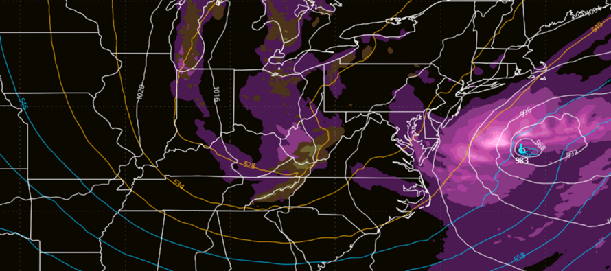
Discussion: Tuesday and Wednesday look similar. Afternoon highs in the 58-65 range. Overnight lows in the 38-50 range. Tuesday looks sunnier than Wednesday, but both days look dry with comfortable humidity.
Thursday into Friday, possibly Saturday morning looks unsettled. There should at least be some rain and light-to-moderate winds. There’s actually a lot of energy around, that if wrapped up properly could produce a solid rainstorm for New Jersey. But the latest model data indicates more of a loosely organized mess of potential energy. I’ll keep an eye on it should the shorter-range models try to wrap it up into something more. But otherwise I am seeing on-and-off periods of rain, breezy winds at times, and generally just a period of nuisance weather in that Thurs PM to Sat AM period.
While areas like NY State (Catskills), some of the Poconos, and maybe SW PA down into WV could see some wet snow from this, New Jersey will likely see rain only. The only exception would be the highest elevations of Sussex County/NWNJ (near High Point Monument area). And even then, meh. Rainfall should occur in the 40s and 50s for most of NJ Thursday and Friday, tapering off by Saturday morning. Thinking a half-inch to an inch of rainfall total for the period. But this is not a snowstorm and not a nor’easter. If model data evolves into that, then the expected forecast will change. But what’s showing right now ain’t it.
After that, we enter another gear of cold for Saturday night into next week. We’re talking highs in the 40s/low-50s and lows in the 20s/30s.
In English: We’re in for a few more nice fall days (Tuesday and Wednesday). Thursday-Saturday morning looks gloomy and rainy with maybe some wet flakes flying for the highest elevations of NWNJ only (small chance). Not a snowstorm. Not a nor’easter. More like a nuisance cold rain with light-to-moderate winds and minor coastal flooding at best. A regular coastal low at most. After that (Saturday-forward), we turn colder in accordance with general climatology. Have a great week and please be safe! JC
Premium Services
KABOOM Club offers an ad-free environment, inside info (Above and Beyond) forecast discussion, your questions prioritized, and early storm impact maps and video releases (ahead of the public). At $1.99 per month, it’s an extremely feasible way to show additional support for Weather NJ and you can turn it on and off for however many months you wish. Think of it as a tip jar with perks. Available on Facebook or Patreon.
My Pocket Meteorologist (MPM), in partnership with EPAWA Weather Consulting, offers professional/commercial interests, whose businesses depend on outdoor weather conditions (snow plowing, landscaping, construction, etc.), with hyper-local text message alerts/forecasts from real meteorologists and access to the MPM premium forum—the most comprehensive and technical forecast discussion available for PA and NJ commercial interests.
KABOOM Shop is live if you want some KABOOM or Weather NJ Merch!
A nor’easter is approaching New Jersey with rain, wind and coastal flooding this weekend. Here’s what to expect, timing and hazards, in detail.

Jonathan Carr (JC) is the founder and sole operator of Weather NJ, New Jersey’s largest independent weather reporting agency. Since 2010, Jonathan has provided weather safety discussion and forecasting services for New Jersey and surrounding areas through the web and social media. Originally branded as Severe NJ Weather (before 2014), Weather NJ is proud to bring you accurate and responsible forecast discussion ahead of high-stakes weather scenarios that impact this great garden state of ours. All Weather. All New Jersey.™ Be safe! JC



LOCAL FORECAST | INTERACTIVE RADAR | LATEST NJ WEATHER ALERTS | WEDDING FORECAST| PRIVACY POLICY
© Copyright 2026 Weather NJ LLC. All Rights Reserved.
Some information that can be found on our website is provided by a private weather station and is not an officially recognized station for weather reporting. Though we always strive to achieve accurate reporting for our own use, it is important that you do NOT depend on the data provided here for any purpose.

