Jan 31: What Superbowl Storm?

Jan 31: What Superbowl Storm?

🕔19:37, 31.Jan 2017

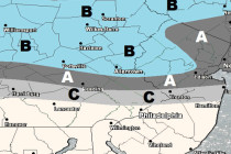
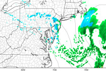
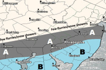
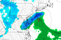
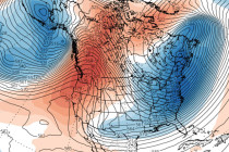
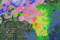
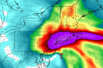
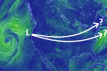
What once looked like a major snow storm on fantasy-range model guidance now appears weak. Let’s break it down… Disco: A low pressure system will come off the Pacific Ocean onto the W US coast near N California/Oregon in a

Read Full Article
Jan 30: Snow Map for Tomorrow

Jan 30: Snow Map for Tomorrow

🕔18:20, 30.Jan 2017

This time NNJ is targeted for a light snow event. Let’s break it down… Click here to view full resolution snow map. Disco: A quick moving shortwave will trail the system that brought snow to extreme SENJ this morning. At

Read Full Article
Jan 30: Flizzards Possible Today

Jan 30: Flizzards Possible Today

🕔11:13, 30.Jan 2017

Instability-driven snow showers are possible later this afternoon into evening. Let’s break it down… First, a quick recap of this morning. The light snow event happened but about 20-30 miles SE of expectation. Overnight dynamics panned out a bit flatter than

Read Full Article
Jan 29: Snow Map for Tomorrow Morning

Jan 29: Snow Map for Tomorrow Morning

🕔19:16, 29.Jan 2017

SNJ has snow on the way. Here’s the last prediction before live observations begin… Click here for full resolution snow map. Disco: It’s apparent, from looking at radar and other live obs data, that energy is rounding the trough and

Read Full Article
Jan 29: Snow Approaching

Jan 29: Snow Approaching

🕔10:20, 29.Jan 2017

Snow is on the way for parts of SNJ. Here are my latest thoughts on amounts and timing… Disco: I’ve always been impressed with the upper-level setup surrounding this “first-of-four” snow possibilities this week. If you look at 500-700mb heights, there’s

Read Full Article
Jan 27: Snow Discussion

Jan 27: Snow Discussion

🕔10:39, 27.Jan 2017

Some snow possibilities are starting to show up on model guidance. Let’s break it down… If I had a nickel every time someone asked me “When’s it going to snow? or “Where’s the snow?” I’d be working Weather NJ full-time.

Read Full Article
Cold Dry Weekend Expected (Jan 27-29)

Cold Dry Weekend Expected (Jan 27-29)

🕔21:55, 26.Jan 2017

Rain has cleared out and we’re now looking cold and dry for the weekend. Let’s break it down… Disco: The frontal wave/disturbance that brought light rainfall to the region has cleared out. A cold front is moving through tonight-tomorrow and it

Read Full Article
Jan 24: The Return of Cold

Jan 24: The Return of Cold

🕔11:15, 24.Jan 2017

The January thaw is about to end as we approach a prolonged period of cold. Let’s break it down… First, a quick recap of the coastal storm. NWNJ saw wintry precipitation in the form of mostly sleet/some wet snow. The

Read Full Article
Jan 23: PM Coastal Storm Update

Jan 23: PM Coastal Storm Update

🕔19:06, 23.Jan 2017

Here’s how the rest of tonight should play out from here… The current radar is detecting sleet (pink) in NNJ and parts of CNJ due to a cold 925mb layer beneath a marginal 850-700mb. This is what’s preventing an all

Read Full Article
Jan 23: Coastal Storm Update

Jan 23: Coastal Storm Update

🕔10:43, 23.Jan 2017

The coastal storm is well underway but peak intensity is still to come. Let’s break it down… Right now, the primary surface low is about 988mb and tracking from W NC to OBX. Upper-level lows are closed off from 300-700mb

Read Full Article