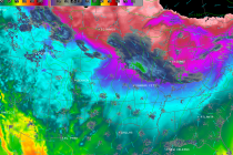
Jan 6: Arctic Cold Air Approaching!
Now that the clipper has moved through, very cold Arctic air will move in behind and keep temperatures well below-average starting tonight and heading into the weekend. The coldest moment of this Arctic wave appears to be early Thursday AM