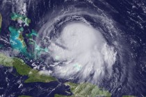
Major East Coast Storm Detected!
First, I feel it’s important for you to know my educational credentials and experience in weather forecasting before placing your trust and faith in me so head over to my about page if you don’t already know who I am


First, I feel it’s important for you to know my educational credentials and experience in weather forecasting before placing your trust and faith in me so head over to my about page if you don’t already know who I am

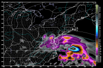
The entire week looks unsettled with more low pressure riding up the coast and an expected frontal passage. It should be a nice rainmaker for New Jersey with a few inches of precipitation possible when all is said and done. Let’s

Low pressure will crawl up the coast this weekend as high pressure first blocks then departs into the ocean. What does this mean? Friday high temperatures should reach the low-to-mid 70s statewide. Skies should feature a mixed bag of sun
A weak coastal low pressure disturbance will be the main driver of possible rain and nuisance conditions this weekend. The rain could begin as early as Saturday afternoon/evening and last through Monday evening. High pressure to the north will block the
A pesky low pressure disturbance will slowly crawl up the east coast and contribute to a period of onshore flow this week. SNJ has the best chance to see any rainfall from the northern side of the system. I wouldn’t

Today and tomorrow should be the last few days of warmer temperatures and elevated humidity. On Sunday we’ll have a dry cold frontal passage which will provide some relief. Beyond that is interesting. After the front moves through on Sunday,

There’s not much to say. The sunny weather continues with a dry frontal passage on Sunday, only making it more pleasant feeling. Let’s break it down. Friday high temperatures should reach the mid-80s inland and maybe just 80 along the

High pressure will sit over our general region this week. This will provide very pleasant and dry sinking air to begin closing out astronomical summer. The week starts cool and crisp but warms up as the ridge builds over the

Another low pressure disturbance will move through the region this weekend bringing cooler and unsettled conditions into at least part of Sunday. After that? High pressure domination with the biggest taste of fall yet! Let’s break it down. Friday high temperatures

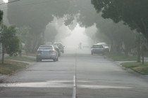
“I don’t think the heavy stuff’s gonna come down for quite awhile.” – Carl Spackler, Caddyshack (1980) The current radar shows isolated-to-scattered showers and thunderstorms moving through our region. An area of heavy rainfall associated with a thunderstorm moved through

LOCAL FORECAST | INTERACTIVE RADAR | LATEST NJ WEATHER ALERTS | WEDDING FORECAST| PRIVACY POLICY
© Copyright 2026 Weather NJ LLC. All Rights Reserved.
Some information that can be found on our website is provided by a private weather station and is not an officially recognized station for weather reporting. Though we always strive to achieve accurate reporting for our own use, it is important that you do NOT depend on the data provided here for any purpose.


