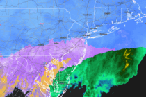
Arctic Nor’easter New Jersey Impact Map
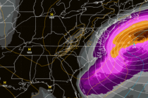
Discussion: The trend out to sea on model guidance continues. At the upper levels, the trough is now modeled with too positive of an axis to allow a storm to bring snow W more than 10-20 miles away from the


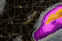
Discussion: The trend out to sea on model guidance continues. At the upper levels, the trough is now modeled with too positive of an axis to allow a storm to bring snow W more than 10-20 miles away from the
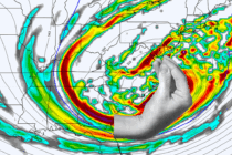
Discussion: You can lean towards a few ideas at this point based live observations of some of the steering currents involved for the immediate players of this storm system. Models are very much in windshield wiper mode. Models showing hits
Discussion: The weekend coastal snowstorm chances are gaining slight confidence. But before we dive in, I have a point to address. This is about the time when everyone tells me, “hey JC my app says this and my app says
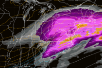
Discussion: Once again, we will remain in article format for this week as there’s a lot going on, simply not able to be captured by a single “Weekly Outlook.” This article today will provide a synoptic storm re-cap of this
Discussion: Snow moved into Cape May early this morning (just after midnight). I was watching the Cape May Cove web cam so I knew when it began. I stayed up until the snow reached my latitude around 2-3am and called

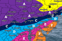
A KABOOM WARNING IS NOW IN EFFECT FOR NNJ FROM TONIGHT THROUGH MONDAY MORNING ASSOCIATED WITH THE ARCTIC SNOWSTORM APPROACHING NEW JERSEY. A KABOOM WATCH REMAINS IN EFFECT FOR THE REST OF NJ AS A WILDCARD POSSIBILITY. Discussion: This will
Discussion: If you’ve been following along then by now you should have made all preparations for a high-impact wintry event in New Jersey this weekend. This includes all your French Toast ingredients, food, plans to stay warm, etc. This snowstorm
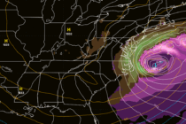
Discussion: Remember, deep breaths everyone. We’re still 36 hours away from this snowstorm beginning. Historically, we’ve seen large changes that drastically affect the outcome in less time than that. We are, however, gaining consistency on the idea of a high-impact

Discussion: This weekend winter snowstorm is a go. Again, deep breath everyone, we are still 3 and a half days from first flakes. Model guidance began a northward trend yesterday and then kicked into a second gear trend northward overnight.

Discussion: This will be a very detailed and in-depth weather discussion about two things: The approaching prolonged cold pattern and the weekend snowstorm potential. The In English section will also lay out a schedule of programming for this week as

LOCAL FORECAST | INTERACTIVE RADAR | LATEST NJ WEATHER ALERTS | WEDDING FORECAST| PRIVACY POLICY
© Copyright 2026 Weather NJ LLC. All Rights Reserved.
Some information that can be found on our website is provided by a private weather station and is not an officially recognized station for weather reporting. Though we always strive to achieve accurate reporting for our own use, it is important that you do NOT depend on the data provided here for any purpose.


