Wet Snow/Rain Event Approaching
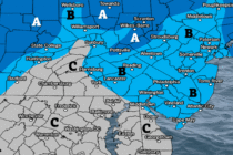
Discussion: It’s important to re-emphasize that this is not a major snowstorm. At the end of the day, it’s a weak surface low becoming a weak coastal low that’s going to clip parts of NJ with wet snow on its


Discussion: It’s important to re-emphasize that this is not a major snowstorm. At the end of the day, it’s a weak surface low becoming a weak coastal low that’s going to clip parts of NJ with wet snow on its
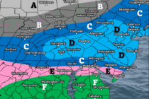
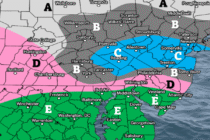
Discussion: This snow potential Sunday night into early Monday morning has been beat to death for the past week+ here and especially in KABOOM Club. We identified this period as a storm signal early and have been walking it in
Discussion: This weekend outlook will be in article form as we are still watching Sunday night into Monday morning for potential wintry impacts in New Jersey. But first lets cover the period leading up to that. A trough, which brought
Discussion: I am gaining high confidence that we won’t see the caliber of cold again, that we experienced end of January through yesterday…where highs top out at 15 and overnight lows go into the negative. This past weekend was likely
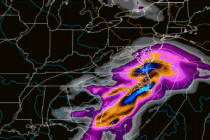
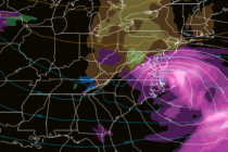
Discussion: At the upper levels, the 250mb-observed jet carves out a trough pattern for the E US through the rest of this weekend. 500mb geopotential height analysis indicates a pure polar N stream energy phasing into a S stream trough
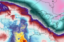
Discussion: We’re going to stay in the “reloading trough” pattern until about Tuesday, Feb 10. This should mark the end of the brutal “core of winter” cold that we’ve had to endure since about Jan 16ish. We’ve had a few
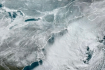
Discussion: The cover shot above is from NOAA GOES satellite imagery showing snow cover across the Mid-Atlantic, Northeast and plains regions of the US. Between the snowstorm last weekend not melting yet, due to Arctic air, and what just hit

LOCAL FORECAST | INTERACTIVE RADAR | LATEST NJ WEATHER ALERTS | WEDDING FORECAST| PRIVACY POLICY
© Copyright 2026 Weather NJ LLC. All Rights Reserved.
Some information that can be found on our website is provided by a private weather station and is not an officially recognized station for weather reporting. Though we always strive to achieve accurate reporting for our own use, it is important that you do NOT depend on the data provided here for any purpose.


