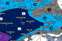
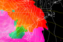
Back to homepage

Posts From Jonathan Carr

Mixed Conditions Possible (June 8-10)

Mixed Conditions Possible (June 8-10)

🕔11:42, 8.Jun 2018

Discussion: A small area of high pressure has moved just off the Delmarva Peninsula. This will give most of NJ SW flow today which will lead to warmer temperatures with noticeably increased humidity compared to prior days. Today should be

Read Full Article
June Discussion with WeatherTrends360

June Discussion with WeatherTrends360

🕔21:23, 4.Jun 2018

It’s time to harness the WeatherTrends360 proprietary weather algorithms to see how the rest of June 2018 should play out. But first lets break New Jersey into climatological regions. We have the higher elevations of NNJ/NWNJ, the interior coastal plain (SWNJ through CNJ and

Read Full Article
Cool Start. Summery Finish (June 4-8)

Cool Start. Summery Finish (June 4-8)

🕔22:05, 3.Jun 2018

Discussion: An upper-level low will influence the Mid-Atlantic US with below-average temperatures through Wednesday. NNJ elevations could fall into the 40s during this period with daytime highs struggling to escape the low-70s for most areas. It looks like Tuesday overnight

Read Full Article
The Crap Weather Continues (June 1-3)

The Crap Weather Continues (June 1-3)

🕔21:27, 31.May 2018

Discussion: Surface winds are currently off the ocean (out of SE) but they are interacting with the lower-mid levels of warmer S/SW flow. This is forcing the saturation that’s driving the current fog. Please be careful overnight and through tomorrow

Read Full Article
Unsettled Conditions Expected (May 29-June 1)

Unsettled Conditions Expected (May 29-June 1)

🕔14:10, 29.May 2018

Discussion: High pressure dropping out of SE Canada (over the Atlantic Ocean to our E) will maintain an onshore flow for NJ over the next few days. By the time we get to Thursday-Friday, the high should be to our

Read Full Article
May 27: Conditions to Improve

May 27: Conditions to Improve

🕔19:20, 27.May 2018

Discussion: Yesterday’s isolated thunderstorms were air mass thunderstorms, meaning they formed mostly from upward motion (diurnal instability/sea breeze front) without wind shear. This is common for the warm sector of your classic Norwegian cyclone model, especially this time of year.

Read Full Article
Great Start. Unsettled Finish (May 25-28)

Great Start. Unsettled Finish (May 25-28)

🕔19:42, 24.May 2018

Discussion: The high pressure responsible for the spectacular weather today and tomorrow (Friday) will slide out into the ocean by Saturday. This will generate return flow which should pump higher humidity into the equation for Saturday. For this reason, all

Read Full Article
Conditions Improve (May 21-25)

Conditions Improve (May 21-25)

🕔13:35, 21.May 2018

Discussion: The only disruptive weather I see this week is Tuesday during PM hours. A cold front should push some rain and possibly thunderstorms through the region. Thunderstorm intensity will be determined by diurnal heating capability during the day on

Read Full Article
Unsettled Conditions Continue (May 18-20)

Unsettled Conditions Continue (May 18-20)

🕔13:22, 18.May 2018

Discussion: The Bermuda high remains stubbornly parked which should keep the return flow up the east coast in place. This should produce a wet Friday (today) and Saturday (tomorrow). Not all day washouts but certainly periods of outdoor cancelling rainfall/storms.

Read Full Article
May 15: Thunderstorms Approaching!

May 15: Thunderstorms Approaching!

🕔16:43, 15.May 2018

Discussion: The line of severe thunderstorms is currently pushing through EPA towards NJ. NWNJ is already up at bat with the rest of NJ on deck. This line should continue it’s NW to SE movement over the next 3-5 hours

Read Full Article