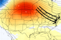
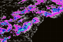
Back to homepage

Posts From Jonathan Carr

Pattern Discussion

Pattern Discussion

🕔15:11, 18.Apr 2024

Discussion: I’ll put the routine weekend outlook out tomorrow but wanted to discuss an early weekend expectation as well as where we’re going in the future. There’s nothing major showing but I’m sensing many of you are becoming curious about

Read Full Article
Amazing Start becomes Meh

Amazing Start becomes Meh

🕔15:27, 15.Apr 2024

Discussion: The upper-levels should stay in a positive anomaly configuration for geopotential heights through this week and weekend. That means we won’t be turning cold. But since the pattern will be slightly zonal, we could turn chilly for a bit.

Read Full Article
Unsettled but Better

Unsettled but Better

🕔15:08, 12.Apr 2024

Discussion: A positive-tilted and progressive trough will push through the Northeast and Mid-Atlantic US Friday-Saturday. We experienced the warm sector and frontal rain from a surface low riding the front of this trough yesterday into this morning. Tonight through Saturday

Read Full Article
More Rain Approaches

More Rain Approaches

🕔13:11, 11.Apr 2024

Discussion: Another synoptic storm system will bring rain today through Friday, possibly Saturday. But it looks pretty good after that. Let’s break it down. First, this will not be a significant rain and wind event like last week. For this

Read Full Article
Warmer Temps. Rainy Pattern Continues.

Warmer Temps. Rainy Pattern Continues.

🕔12:19, 8.Apr 2024

Discussion: I imagine there will be a few people calling out with “stomach bugs” tomorrow (Tuesday) as temps surge into the 70s for most of NJ with ample sunshine. Today (Monday) is a transitional day between the colder/rainy pattern and

Read Full Article
Conditions Gradually Improve

Conditions Gradually Improve

🕔15:23, 5.Apr 2024

Discussion: The upper low is still meandering off coastal New England (Gulf of Maine area) placing New Jersey on its SW side. We therefore have NW flow with lower geopotential heights and unsettled conditions. As long as we are within

Read Full Article
Stormier Conditions Approaching!

Stormier Conditions Approaching!

🕔16:39, 2.Apr 2024

Discussion: Another slug of precipitation is just finishing up in NJ and departing out to sea. We should see a small lull this evening before more returns overnight into tomorrow (Wednesday). Tomorrow will likely feature the heaviest rainfall and stormiest

Read Full Article
Cooler Rainier Pattern Sustains

Cooler Rainier Pattern Sustains

🕔16:09, 1.Apr 2024

Discussion: An upper-level low will move into the region by Tuesday/Wednesday and meander around the Mid-Atlantic/Northeast US through this weekend. It will keep NJ wet through at least Thursday night, possibly Friday. The stormiest conditions should occur Wednesday PM just

Read Full Article
Milder Mostly Nice Weekend. Snow?

Milder Mostly Nice Weekend. Snow?

🕔15:21, 29.Mar 2024

Discussion: This weekend is straightforward. A mild and zonal setup with a weak disturbance floating through Saturday night into Sunday morning. Looks like nuisance rain showers that will occur overnight—sparing Saturday and Sunday daylight hours with just sun, clouds, and

Read Full Article
Another Soaker Approaches

Another Soaker Approaches

🕔15:03, 27.Mar 2024

Discussion: The center of the approaching system is actually in SE Canada which is producing a large mid-latitude cyclone for much of E North America. For NJ, we’ll see the southern side of it in the form of a cold

Read Full Article