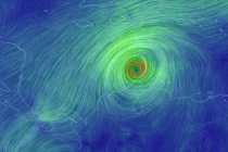
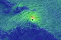
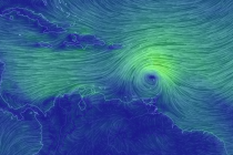
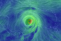
Back to homepage

Feature POST on Homepage

June 8: Thunderstorms Approaching!

June 8: Thunderstorms Approaching!

🕔17:16, 8.Jun 2015

Rain and severe-warned thunderstorms are pushing through parts of Pennsylvania. Conditions are ripe for damaging winds and possibly tornadoes for areas well to the NW of I-95. The only part of New Jersey that could possibly be subject to such

Read Full Article
Week Begins Stormy. Ends Hot (June 8-12)

Week Begins Stormy. Ends Hot (June 8-12)

🕔19:36, 7.Jun 2015

Northerly low pressure will drag moisture through the region early this week. That should present the threat for rain and thunderstorms. Everything should improve by Wednesday morning as hot weather settles in to finish out the week. Let’s break it

Read Full Article
Mostly Nice Weekend Expected (June 5-7)

Mostly Nice Weekend Expected (June 5-7)

🕔19:15, 4.Jun 2015

This bizarre pattern that we’ve been in is about to improve. The weekend could start with lingering showers but high pressure will eventually invade from the N/NW and boot everything out of the region. Let’s break it down: Friday should top

Read Full Article
NJ Long Range Outlook – What to Expect through June!

NJ Long Range Outlook – What to Expect through June!

🕔12:16, 3.Jun 2015

It’s time to use the crystal ball and harness the WeatherTrends360 proprietary weather algorithms for a look at the rest of June 2015. But first lets break New Jersey into proper climatological regions. We have the upper elevations of NWNJ, the interior coastal

Read Full Article
Cooler Rainy Week Expected (June 1-5)

Cooler Rainy Week Expected (June 1-5)

🕔09:23, 1.Jun 2015

At least the first half of the week looks wet with much cooler temperatures than we’ve recently acclimated to. With a little luck we’ll be clear and sunny heading into the weekend depending on how much tropical moisture kicks up the

Read Full Article
May 31: Showers and Storms Rock NNJ. SNJ on Deck!

May 31: Showers and Storms Rock NNJ. SNJ on Deck!

🕔19:34, 31.May 2015

A slow moving boundary with showers and thunderstorms is pushing through the region. This should bring substantial widespread rainfall to the entire state by Tuesday morning in addition to isolated instances of severe weather. NWNJ will see the rainfall first, which

Read Full Article
Weekend Starts Beautiful Ends Wet (May 29-31)

Weekend Starts Beautiful Ends Wet (May 29-31)

🕔10:09, 29.May 2015

We should stay warm and summery for the first half of the weekend but then a low pressure disturbance and cold front will move through. This should bring rain to the region between Sunday and Monday before setting up a much cooler

Read Full Article
May 28: More Thunderstorms Expected

May 28: More Thunderstorms Expected

🕔10:44, 28.May 2015

New Jersey is in for another warm and humid day with thunderstorm potential. Yesterday’s thunderstorms were primarily held NW of the turnpike. Everyone to the SE was subject to fizzle due to southerly flow and cooler stable air mass associated

Read Full Article
May 27: Watching Thunderstorm Potential Today

May 27: Watching Thunderstorm Potential Today

🕔10:12, 27.May 2015

It looks like New Jersey is in for another warm and humid day away from the ocean. This presents a favorable environment for thunderstorm development as atmospheric instability couples with high dew points for cumulonimbus cloud fuel. The overall setup

Read Full Article
Summery Week Expected (May 26-29)

Summery Week Expected (May 26-29)

🕔10:21, 26.May 2015

High pressure will remain parked in the Atlantic Ocean to our east as multiple waves of low pressure pass through to our west. This traditionall means warm temperatures with unsettled conditions for New Jersey. Heat indices should break 90 with an

Read Full Article