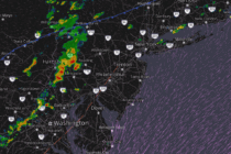
Thunderstorms Approaching Jersey
Discussion: With actual temps over 90 for most of NJ and dew points well into the 70s, most of NJ is sitting with a heat index of ~100-110 less Sussex County…as of about 4pm. I’m seeing some high levels of


Discussion: With actual temps over 90 for most of NJ and dew points well into the 70s, most of NJ is sitting with a heat index of ~100-110 less Sussex County…as of about 4pm. I’m seeing some high levels of

Discussion: I hope everyone had a great July 4th weekend! As promised, Friday was spectacular, and Saturday-Sunday saw a slow rebuild of humidity and temperatures. Here we are today (Monday) when the relentless humidity was expected to return. And that

Discussion: A small trough is approaching NJ and will swing through between today (Thursday) and Sunday. As it approaches closer tonight (Thursday night), expect a series of showers and thunderstorms to start their strongest in NWNJ around 5-7pm and then
Discussion: It’s time for a cold front to push all this humid storminess out of the region. It’s going to be a process that starts tonight and ends Friday morning. Let’s dive into it… The surface map (shown above) indicates

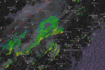
Discussion: This morning there was a stationary boundary draped across SNJ which is now advancing northward through CNJ as a warm front. This is the culprit for the current CNJ/SNJ storms firing along the extended Mason Dixon line and points

Discussion: Hard to deduce much from 250/500mb levels. The jet will be a little N of NJ. Geopotential height anomalies are modeled only a little above average. But overall a near-zonal flow until a trough dips into the region Tuesday-Wednesday.
Discussion: Now that most of NJ is out of the oven (Mon-Wed heat) and resting (except for SWNJ and WCNJ – they are still cooking), I wanted to update for the coming weekend. Not quite yet the detailed weekend outlook

Discussion: In the words of the late Glenn Frey, “The Heat is On!” De na NA nana da NAna NAna! The upper jet, observed at 250mb, should stay well to the N of NJ this week. From 500mb analysis, a

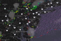
Discussion: We’re now in a warm sector. The warm front is through and winds are changing to more of a SW direction with increasing temperatures and humidity. A round or two of showers and thunderstorms are possible today (Wednesday) and

Discussion: The upper-jet, observed at 250mb, should stay N of NJ for most of the foreseeable future outside of a small dip this Thursday-Friday. That jives with 500mb heights analysis of the bottom of an expected trough grazing through NJ

LOCAL FORECAST | INTERACTIVE RADAR | LATEST NJ WEATHER ALERTS | WEDDING FORECAST| PRIVACY POLICY
© Copyright 2025 Weather NJ LLC. All Rights Reserved.
Some information that can be found on our website is provided by a private weather station and is not an officially recognized station for weather reporting. Though we always strive to achieve accurate reporting for our own use, it is important that you do NOT depend on the data provided here for any purpose.


