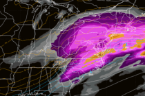
The Good Stuff is Here
Discussion: The upper jet and heights are suggesting a series of upper lows/troughs swinging through this week. A cold front is currently riding the front of a trough and pushing through NJ from W to E which is dropping dew
Discussion: Erin is steaming away from the E US towards the N Atlantic/European region. Gone are any shower or coastal flooding concerns. Beach erosion seems minor but won’t be measured until Saturday evening and that’s because some dangerous rip currents
Discussion: This will likely be the last update focused on Hurricane Erin. The rain is donezo and will continue to pull away from the coast overnight. All that is left from Erin are rough surf, dangerous rip currents and a
Discussion: Hurricane Erin’s track is pretty locked in at this point. She’s a few hundred miles NE of the Bahamas and has turned well to the NW. Erin will pass between two ridges (an area of weakness), one over SC/SE
Discussion: The first thing I want to emphasize is that Erin will not be striking New Jersey with a major hurricane, yet alone the US east coast. I’ve seen some content out there suggesting such and it lacks any sort
Discussion: Before I cover Erin’s latest update, let’s focus on New Jersey this weekend. A broad ridge across the US will build and flex for the Mid-Atlantic and NorthEast US from now until Sunday morning. A trough will then force
Discussion: We have ourselves a ~Verde origin system worth watching as it crosses the Atlantic Ocean via the trade winds over the next several days and ultimately decides where to go from either just over the NE Antilles or just
Discussion: The upper levels remain unremarkable with little deduction possible. A lot of weak zonal flow with nothing anomalous in either direction regarding geopotential height anomalies. We look rather dry through this weekend and likely through Tuesday as heat and
Discussion: The upper levels are rather unremarkable with little deduction…a rather zonal flow with no anomalous height anomalies in either direction. The main player this week will be high pressure stationed over the NE US/SE Canada, providing stiff onshore flow
Discussion: The upper jet is taking a little dip over NJ for this weekend into early next week. Not an anomalous trough by any means, it’s pretty weak, but at least a much needed cooldown after this past week. The