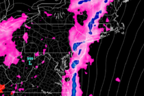
Back to homepage

Latest NJ Weather Alerts

Cool Crisp Start (Oct 16-20)

Cool Crisp Start (Oct 16-20)

🕔23:43, 15.Oct 2017

Discussion: The upper levels indicate a transient trough swinging through early this week. This should keep us rather chilly for Monday and Tuesday with NW flow. Wednesday through Sunday then looks beautiful with near-70 highs and sunny skies. Temps should

Read Full Article
Warm Unsettled Conditions Expected (Oct 13-15)

Warm Unsettled Conditions Expected (Oct 13-15)

🕔20:19, 12.Oct 2017

A few quick programming notes: 1) I’m filling in at the Press of Atlantic City through Tuesday. 2) The Weather NJ mobile app has been disabled and discontinued. A new and improved mobile app is in the works with an

Read Full Article
Wet Start Expected (Oct 9-13)

Wet Start Expected (Oct 9-13)

🕔18:12, 8.Oct 2017

Discussion: The upper levels continue to show dominant ridging over the NE US through at least next weekend. Both Nate’s remnants and another trailing disturbance will be running directly into this ridge and are therefore both expected to fizzle energy-wise.

Read Full Article
Warm Weekend Expected (Oct 6-8)

Warm Weekend Expected (Oct 6-8)

🕔11:15, 6.Oct 2017

Discussion: I’m seeing a lot of dominant upper-level ridging over the east coast for much of the next two weeks. The lower-mid levels support the expected warm and muggy feel through this weekend and during the Nate remnant impact period

Read Full Article
Through the Rest of October

Through the Rest of October

🕔13:39, 2.Oct 2017

It’s time to harness the WeatherTrends360 proprietary weather algorithms to see how the rest of October 2017 should play out. But first lets break New Jersey into proper climatological regions. We have the higher elevations of NNJ/NWNJ, the interior coastal plain (SWNJ through CNJ and

Read Full Article
Temperatures to Moderate (Oct 2-6)

Temperatures to Moderate (Oct 2-6)

🕔12:03, 2.Oct 2017

Discussion: The upper-level pattern is fairly straightforward this week. A strong ridge will build over SE Canada/NE US between Monday and Thursday. At the lower-levels this means dry sinking air with warmer surface temperatures surrounding a dominant area of high

Read Full Article
Cool Crisp Conditions Expected (Sept 29-Oct 1)

Cool Crisp Conditions Expected (Sept 29-Oct 1)

🕔11:42, 29.Sep 2017

Who’s ready for some hoodie weather? Discussion: This entire weekend and most of next week will be under high pressure control. A pesky upper-level disturbance is expected to move through late Friday night through Saturday afternoon. This could bring some

Read Full Article
Hot Start Cool Finish (Sept 25-29)

Hot Start Cool Finish (Sept 25-29)

🕔11:41, 25.Sep 2017

Discussion: Jose is gone, even the system’s upper-level energy. We’re left with the decaying stubborn ridge over NE US/SE Canada that will take time to break down completely. Therefore, the current warm and muggy temperatures should gradually step down through

Read Full Article
Sept 23: Maria to Miss New Jersey

Sept 23: Maria to Miss New Jersey

🕔16:06, 23.Sep 2017

Discussion: The 12Z model suite today unanimously initialized with good agreement on live-observations, especially with respect to the 250-500mb flow around the approaching trough. Therefore, I’m confident in serious upper-level E/NE (out to sea) steering currents north of the 35N

Read Full Article
Sept 22: East Coast Concerns Remain

Sept 22: East Coast Concerns Remain

🕔14:42, 22.Sep 2017

Discussion: There is no doubt a westward trend of Maria’s expected track on most model guidance today, especially when comparing to last night and yesterday’s model suites. Let’s talk present before talking future. Here are the current vitals from the

Read Full Article