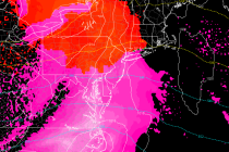
Back to homepage

Latest NJ Weather Alerts

Feb 21: Storm Update

Feb 21: Storm Update

🕔19:08, 21.Feb 2016

I’m getting a much better picture of how this week is going to play out weather-wise. The main low pressure system that I’ve been monitoring for Tuesday-Wednesday has trended NW with its track. Given that the energy is now getting

Read Full Article
Mild Weekend Expected (Feb 19-21)

Mild Weekend Expected (Feb 19-21)

🕔21:43, 18.Feb 2016

We’re well below freezing tonight through tomorrow morning but temperatures then look to moderate for the weekend. Then we’re likely going to have to deal with a coastal low pressure system bringing rain, wind and coastal flooding to the Jersey

Read Full Article
Feb 16: Moving Forward

Feb 16: Moving Forward

🕔21:18, 16.Feb 2016

Some short-range model guidance has been hinting at a period of light snow showers overnight/early tomorrow morning but there’s just not much bite to them on live obs. Basically some weak energy is being strung out to our south but has the

Read Full Article
Feb 16: Tuesday Morning Observations

Feb 16: Tuesday Morning Observations

🕔09:30, 16.Feb 2016

A lot of rain is about to fall between now and afternoon hours. The low is tracking through PA from S/SW to N/NE towards interior New England. As it does so, a very heavy band of precipitation will move through New

Read Full Article
Feb 15: Monday Night Observations

Feb 15: Monday Night Observations

🕔21:53, 15.Feb 2016

Most precipitation has changed over from snow to either sleet, freezing rain or plain rain depending on where you are. Most of SENJ has spiked into the 40s and should be all rain from hereon out. Parts of SWNJ and WCNJ are

Read Full Article
Feb 15: Late Afternoon Observations

Feb 15: Late Afternoon Observations

🕔16:34, 15.Feb 2016

Precipitation continues to spread northward through New Jersey. The high pressure in the ocean has provided E/SE flow which has taken surface temps for coastal NJ and SENJ above freezing. The 850mb southerly jet is taking shape from the developing

Read Full Article
Feb 15: Monday Morning Observations

Feb 15: Monday Morning Observations

🕔10:48, 15.Feb 2016

After some “here and there” light snowfall overnight, heavier rates are now pushing further into SNJ. The principals of this system remain as called. Front end snow (mostly light accumulations) eventually changing to all rain with a possible period of ice between (moreso

Read Full Article
Feb 13: Ice Storm Detected

Feb 13: Ice Storm Detected

🕔19:41, 13.Feb 2016

Model guidance is starting to converge on a solution for Monday into Tuesday. Here are my current thoughts. Tomorrow night’s map will have snow accumulations and ice estimations. Such values are currently too uncertain for me to estimate: The darkest

Read Full Article
Feb 11: Possible Ice Storm Detected

Feb 11: Possible Ice Storm Detected

🕔20:35, 11.Feb 2016

The most recent model guidance is indicating that a low pressure disturbance will form in the Texas area early Monday morning. It should then track through the SE US and turn up the east coast. It will grab a lot of

Read Full Article
Frigid Weekend Expected (Feb 11-14)

Frigid Weekend Expected (Feb 11-14)

🕔12:06, 10.Feb 2016

The weekend looks frigid and another winter storm signal is showing for early next week. Let’s break it all down. Today‘s high temperatures should reach the mid-to-upper 30s statewide. AM snow bands should move offshore but we’re subject to random localized snow

Read Full Article