Sept 25: His Name will be Matthew
This is a great time to test out the new forecasting strategy as all eyes now turn to the formation of Matthew in the Atlantic Ocean. If you’re looking for a “will this hit me on my favorite NJ shore


This is a great time to test out the new forecasting strategy as all eyes now turn to the formation of Matthew in the Atlantic Ocean. If you’re looking for a “will this hit me on my favorite NJ shore

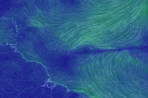
Other than a small chance of a passing shower along a mostly dry cold front, the first weekend of fall looks pretty good. Let’s break it down… Nerdy Disco: Perhaps some upstream physics were slightly disrupted by the typhoon activity
Model guidance as well as live observations suggest Karl staying out to sea. Bermuda interests however should still monitor and the US East Coast should expect more strong rip currents and possibly some increased swell. On top of that, Tropical Storm

We’ll start the week with some much needed rainfall however once clear, the week looks pretty good. Let’s break it down… Monday (Sept 19) high temperatures should reach the mid-70s statewide. Skies should be mostly cloudy. Rainfall (anything from a

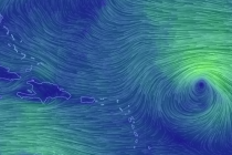
Tropical Storm Karl formed last week just S of the Cape Verde region off W Africa. He is now steaming towards the Bermuda Triangle and is expected to reach hurricane strength. There is much uncertainty as to what Karl will do

The weekend should start out beautiful and end rainy. Let’s break it down… First, a huge shout out to my buddy Kaden Demopoulos! His mom was nice enough to bring him to the local library so he could help me

It’s time to harness the WeatherTrends360 proprietary weather algorithms to see how the rest of September 2016 should play out. But first lets break New Jersey into proper climatological regions. We have the higher elevations of NNJ/NWNJ, the interior coastal plain (SWNJ through CNJ

High pressure should have control for most of this week. Let’s break it down… Nerdy Disco: High pressure is currently overhead and moving E. This should keep Monday and Tuesday rather pleasant in comparison to the weather we’ve recently seen.

While some rain is expected this weekend, most of it should fall during overnight hours sparing “most” daytime hours. Let’s break it down… Nerdy Disco: A warm front should move through the region from S to N late Friday night into

Summery conditions are on their way back. Let’s break it down… Nerdy Disco: Hermine will now fizzle out and absorb into the jet stream over the ridge moving into place. Her surface low has been stacked over the upper-level low

LOCAL FORECAST | INTERACTIVE RADAR | LATEST NJ WEATHER ALERTS | WEDDING FORECAST| PRIVACY POLICY
© Copyright 2026 Weather NJ LLC. All Rights Reserved.
Some information that can be found on our website is provided by a private weather station and is not an officially recognized station for weather reporting. Though we always strive to achieve accurate reporting for our own use, it is important that you do NOT depend on the data provided here for any purpose.


