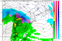
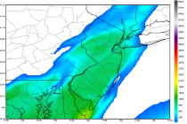
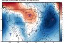
Back to homepage

Latest NJ Weather Alerts

NJ Long Range Outlook – We’re Almost There!

NJ Long Range Outlook – We’re Almost There!

🕔10:15, 7.Mar 2015

There’s a light at the end of the tunnel after the recent cold we’ve had to endure. For best results lets harness the WeatherTrend360’s proprietary algorithms again as we close out March. First lets break New Jersey into proper climatological regions. We have the upper

Read Full Article
Weekend Starts Cold but Moderates (Mar 6-8)

Weekend Starts Cold but Moderates (Mar 6-8)

🕔10:15, 6.Mar 2015

The weekend starts out cold on Friday but moderates through Sunday and into next week. We’re not looking to bad at all. Here’s what to expect in detail: Friday should reach the mid-to-upper 20s for high temperatures. Skies should be mostly

Read Full Article
Mar 3: Snow Storm Detected!

Mar 3: Snow Storm Detected!

🕔14:32, 3.Mar 2015

Here is my snow map for Wednesday evening into Thursday. This includes only snow that falls after the changeover from rain to ice to snow tomorrow evening: Only light snow is expected today (nothing serious) before changing to sleet/freezing rain and

Read Full Article
Mar 2: Watching Two Wintry Disturbances

Mar 2: Watching Two Wintry Disturbances

🕔11:41, 2.Mar 2015

A cut-off low pressure disturbance in the SW US is responsible for sending a few waves of energy eastward along a slow moving frontal boundary. This means a few snow chances for New Jersey this week. The frontal boundary will

Read Full Article
Wintry Week Expected (Mar 2-6)

Wintry Week Expected (Mar 2-6)

🕔10:26, 2.Mar 2015

We have a lot to talk about this week. A mild Wednesday sandwiched between snow on Tuesday and Thursday. In like a lion! Monday should reach the mid to upper 30s statewide for high temperatures. Clouds should gradually clear with stiff

Read Full Article
Mar 1: Winter Storm Approaching

Mar 1: Winter Storm Approaching

🕔09:36, 1.Mar 2015

Snow should begin falling between now and noon from west to east. Warm air will try to invade from the south while the surface holds on to colder temperatures. We should be used to these by now. Here are my

Read Full Article
Cold but Dry Weekend Expected (Feb 27-Mar 1)

Cold but Dry Weekend Expected (Feb 27-Mar 1)

🕔13:23, 26.Feb 2015

We’re cold through overnight Saturday with the entire state staying below freezing for lows and highs. A few more nights of single digit temperatures are likely. On Sunday we begin to moderate some with 50s possible next week. There are also a

Read Full Article
Feb 25: Snow Map for Tomorrow

Feb 25: Snow Map for Tomorrow

🕔14:10, 25.Feb 2015

The map is pretty straight forward. Snow arrives from the S/SE overnight and clears out by noon at the latest tomorrow. A nuisance for most of NJ but possible significant impact to extreme SENJ. Be safe! JC Jonathan CarrJonathan Carr

Read Full Article
Feb 25: SENJ Snow Likely Thursday AM

Feb 25: SENJ Snow Likely Thursday AM

🕔09:56, 25.Feb 2015

Model guidance has continued to nudge precipitation northwestward into SENJ. Cumberland, Cape May, Atlantic, and SE parts of Ocean and Burlington Counties have the best chance to see light to moderate snowfall between 4AM and 10AM tomorrow. Snow showers are now reaching

Read Full Article
Feb 24: Watching Thursday Morning

Feb 24: Watching Thursday Morning

🕔10:13, 24.Feb 2015

The storm that was modeled last week for this Wednesday-Thursday shifted southward over this past weekend. Over the last 24 hours it has trended slightly back northward and shifted potential impacts for SENJ closer to the 2AM-11AM Thursday morning period. We

Read Full Article