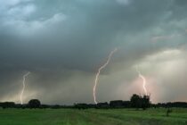
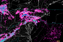
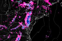
Snow Tonight fo NNJ/CNJ
Discussion: We have a few things to talk about. Many are ready for spring weather conditions and all the activities that accompany such. The snow lovers however are in denial at this point evident by the many “I will believe
Discussion: The storm system is currently (Friday afternoon) approaching the S Great Lakes area. This will sever the east coast ridge leaving pieces above and below it. The above piece should stop the low’s northward progression overnight tonight (Friday night)
Discussion: Another storm system will push through NJ between Friday and Saturday with mostly wet impacts to most of the state. The only area that could see a wintry mix IMO is N of I-80 and NW of I-287…basically Sussex,
Discussion: Meteorological winter ends after today. Meteorological spring begins tomorrow as each new day features increased sunlight duration and sun angle. Heck, we change the clocks soon at which point we’ll have horizon dayglow to 7pm+. General climatology will make
Discussion: The wintriest snowstorm of the season is approaching NNJ. This isn’t saying much this season but here we are. I don’t see this being a Kaboomable event. I think maybe some spots in NNJ have a chance of double
Discussion: As expected, yesterday’s light snow event was not a big deal. Some saw anything from flurries to snow showers with little-to-no accumulation. Some northern areas saw trace accumulations mostly on natural surfaces. This was a great example of conversational
Discussion: As the worst winter (snow-wise) since 2011-2012 begins to sunset, it might try to remind us that we are indeed still in the season of winter. Sun angle is climbing higher each day. Climatology is now stacked against daytime
Discussion: Some rain moved through last night and scraped extreme NNJ with some wintry precip. No big deal. We’ll see another round of showers this afternoon preceding a weak cold front (really just a sinking boundary). We’ll then warm up
Discussion: Real quick, rain is departing to the E over the ocean and a cold front is moving in to drop temperatures for this afternoon through tomorrow night. By Sunday, the mild conditions will return and stick around until about
Discussion: Our coastal storm cleared out earlier this morning but the back-side cold has not yet arrived. Remember this coastal storm was a small area of colder air within an overall/regional warm air mass. So as soon as we popped