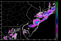
May 31: Showers and Storms Rock NNJ. SNJ on Deck!
A slow moving boundary with showers and thunderstorms is pushing through the region. This should bring substantial widespread rainfall to the entire state by Tuesday morning in addition to isolated instances of severe weather. NWNJ will see the rainfall first, which