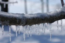
Dry and Colder (Feb 28-Mar 1)
Discussion: The 250mb jets (Polar and Pacific) are converging to the SW of NJ and keeping the overall jet pattern S of NJ this weekend. The jet should rise back over and N of NJ by Tuesday followed by a


Discussion: The 250mb jets (Polar and Pacific) are converging to the SW of NJ and keeping the overall jet pattern S of NJ this weekend. The jet should rise back over and N of NJ by Tuesday followed by a

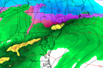
Discussion: The upper-level (250mb) jet looks very aggressive over the Mid-Atlantic and NorthEast US this Wednesday overnight into Thursday morning. I see a strong jet streak with ample divergence and difluence aloft. This was the signal I mentioned last week.

Discussion: Another very positive-tilted upper-level trough will swing through over the next few days before giving way back to above-average geopotential heights Saturday into the first half of next week. That should put NJ inside the trough tonight through tomorrow

Discussion: A positive-tilted and progressive trough is currently swinging through the region and should give way to the front side of a ridge with upper-level NW flow. This is responsible for bringing the colder conditions that started last night (Thursday)

Discussion: Real quick, some precipitation is moving through tonight. Extreme NNJ could see some wintry precipitation type from this. It should move out by tomorrow morning. E US ridging and a Bermuda high should keep temperatures above average through Wednesday.

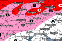
Discussion: The next and more significant precipitation slug moves through between tonight and about 6am tomorrow morning. SENJ should receive more rainfall than NWNJ but everyone’s on the hook for widespread periods of moderate, sometimes heavy, rain overnight tonight. Precipitation
Discussion: It’s been a somewhat colder day than the past few. The boundary has been pulled southward over NNJ from the back-side cyclonic flow of the weak wave that just departed. NNJ is already down into the 30s and some
Discussion: There’s no need to cover the overall global polar and Pacific patterns that are producing an unfavorable environment for winter storm development. Now it’s all about the thread-the-needle wintry events that can still occur in an unfavorable winter pattern.

It’s time to harness WeatherTrends360 technology and look at how the rest of February 2020 should play out. WeatherTrends360 algorithms are documented with an 84% verification rate and are based on oceanic water cycles, time table series and very complex
Discussion: While the overall Polar and Pacific weather patterns, including key teleconnections and oscillations, remain generally unfavorable for winter weather in New Jersey, we do have a few thread the needle events to watch this week. We’re basically going to

LOCAL FORECAST | INTERACTIVE RADAR | LATEST NJ WEATHER ALERTS | WEDDING FORECAST| PRIVACY POLICY
© Copyright 2026 Weather NJ LLC. All Rights Reserved.
Some information that can be found on our website is provided by a private weather station and is not an officially recognized station for weather reporting. Though we always strive to achieve accurate reporting for our own use, it is important that you do NOT depend on the data provided here for any purpose.


