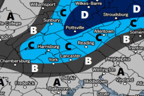
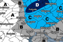
Back to homepage

Posts From Jonathan Carr

Muggy Unsettled Weekend Expected (Aug 12-14)

Muggy Unsettled Weekend Expected (Aug 12-14)

🕔19:29, 11.Aug 2016

High pressure over Bermuda will keep a persistent SW flow over New Jersey this weekend. That means hazy, hot and humid weather with scattered rain and storms. Let’s break it down… Friday (Aug 12) high temperatures should reach the low-to-mid 90s

Read Full Article
Humidity to Return (Aug 8-12)

Humidity to Return (Aug 8-12)

🕔21:47, 7.Aug 2016

The first part of the week looks dry and pleasant. Humidity should then build mid-week and lead us into an unsettled weekend. Let’s break it down: Disco: High pressure will have control of most of the week. Monday and Tuesday should

Read Full Article
Mostly Nice Weekend Expected (Aug 5-7)

Mostly Nice Weekend Expected (Aug 5-7)

🕔10:54, 5.Aug 2016

We’re going to deal with a period of unsettled weather along a cold front on Saturday. Otherwise, the weekend doesn’t look too bad. Let’s break it down: Disco: A low pressure system in Canada will drag two areas of lifting

Read Full Article
Long Range Outlook: Through August 2016

Long Range Outlook: Through August 2016

🕔12:04, 2.Aug 2016

It’s time to harness the WeatherTrends360 proprietary weather algorithms to see how the rest of August 2016 should play out. But first lets break New Jersey into proper climatological regions. We have the higher elevations of NNJ/NWNJ, the interior coastal plain (SWNJ through CNJ

Read Full Article
Conditions Improve (Aug 1-5)

Conditions Improve (Aug 1-5)

🕔09:54, 1.Aug 2016

Today could end up stormy with remnant unsettled conditions lasting through tomorrow. The rest of the week looks pretty good. Let’s break it down: Disco: We’re still waiting for the frontal boundary, that has haunted us with humid unsettled conditions,

Read Full Article
Unsettled Weekend Expected (July 29-31)

Unsettled Weekend Expected (July 29-31)

🕔17:42, 28.Jul 2016

While not a total washout, most of the weekend looks unsettled. Let’s break it down… Disco: A frontal boundary is currently draped across the Ohio Valley, southern Pennsylvania and through central/southern New Jersey. This frontal boundary will act as a

Read Full Article
July 28: Sailor Take Warning

July 28: Sailor Take Warning

🕔10:40, 28.Jul 2016

A low pressure system will track across the Mid-Atlantic US, through New Jersey and up into coastal New England late tonight into tomorrow. Most of New Jersey should see at least a quarter-to-half inch of rainfall however a thinner axis

Read Full Article
Summery Week Expected (July 25-29)

Summery Week Expected (July 25-29)

🕔11:17, 25.Jul 2016

Most of the week looks summery with possibly a slight break in humidity mid-week. Friday and into the weekend looks cooler but stormy. Let’s break it down: Monday (July 25) high temperatures should reach into the 90s for most. Coastal

Read Full Article
Hot Humid Weekend Expected (July 22-24)

Hot Humid Weekend Expected (July 22-24)

🕔09:50, 22.Jul 2016

Tropical air mass will build over the region this weekend creating above-average temperatures and elevated humidity for most of NJ. We’re not looking at anything record breaking, but it will be hot. Let’s break it down: Friday (July 22) high

Read Full Article
July 19: Heat Wave Detected

July 19: Heat Wave Detected

🕔20:24, 19.Jul 2016

High pressure currently has control of the region but the heat and humidity are expected to return. High pressure is anti-cyclonic, which in the northern hemisphere spins clockwise (opposite of a low pressure system). So when high pressure approaches from

Read Full Article