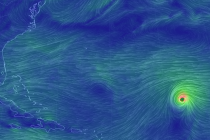
Back to homepage

Feature POST on Homepage

More Mild Weather and T-Storms (Feb 27-Mar 3)

More Mild Weather and T-Storms (Feb 27-Mar 3)

🕔11:41, 27.Feb 2017

More spring tease weather this week including mid-week thunderstorms and possible late-week snow.  Let’s break it down… Disco: Another low pressure system will form in the Midwest US and track through the Great Lakes into SE Canada. This will drag another

Read Full Article
Feb 25: Thunderstorms Approaching!

Feb 25: Thunderstorms Approaching!

🕔11:47, 25.Feb 2017

Thunderstorms are pushing through PA and are on the way to New Jersey. Let’s break it down… The above image represents the severe threat assessment from the National Weather Service Storm Prediction Center. As you can see most of W NJ

Read Full Article
Unsettled Mild Weekend Expected (Feb 24-26)

Unsettled Mild Weekend Expected (Feb 24-26)

🕔20:01, 23.Feb 2017

All sorts of weather expected this weekend. Let’s break it down… Disco: So that there’s no confusion, the cover image only represents possible conditions Saturday evening. The entire weekend will not be rainy and stormy however it will start milder

Read Full Article
Another Mild Period (Feb 20-24)

Another Mild Period (Feb 20-24)

🕔13:57, 20.Feb 2017

More mild weather is on the way and possibly even some natural fireworks for the weekend. Let’s break it down… Disco: Northerly flow, currently associated with the front-side of weak approaching high pressure, has chilled the region down. This should

Read Full Article
Milder Weekend Expected (Feb 17-19)

Milder Weekend Expected (Feb 17-19)

🕔19:31, 16.Feb 2017

This weekend kicks off a mild stretch. Let’s break it down… Disco: Not much to speak of synoptically. A few areas of weak high pressure will be moving through the E US. A low pressure system will be passing by

Read Full Article
Feb 15: Cold Winds Approaching

Feb 15: Cold Winds Approaching

🕔14:28, 15.Feb 2017

Disco: Two shortwaves have tracked across the US and are now phasing together for another powerful coastal New England storm. Had the phase happened a bit earlier, then New Jersey could have seen a significant to major winter storm. Instead,

Read Full Article
Unsettled Week Expected (Feb 13-17)

Unsettled Week Expected (Feb 13-17)

🕔11:04, 13.Feb 2017

An active February pattern continues this week. Let’s break it down… Disco: As far as the Wednesday-Thursday system, there still exists two major players on the field. This period of winter storm potential was first identified last week with a positive-phased

Read Full Article
Feb 12: Storm Update and High Wind Warning

Feb 12: Storm Update and High Wind Warning

🕔10:24, 12.Feb 2017

Mixed wintry precipitation is falling across NNJ. Winds are going to crank tonight-tomorrow. Let’s break it down… Disco: High pressure to the NE is back-feeding the surface and 925mb level with cold air (between I-78/I-80 and northward). The approaching low

Read Full Article
Feb 11: Snow and Ice Impact Maps for NNJ

Feb 11: Snow and Ice Impact Maps for NNJ

🕔14:45, 11.Feb 2017

After review of today’s guidance, here’s our expected snow and ice totals for NNJ overnight tonight and tomorrow… Click here for full resolution snow map. Click here for full resolution ice map. In English: Wintry precipitation could produce dangerous conditions for

Read Full Article
Feb 11: Another Northeast US Storm

Feb 11: Another Northeast US Storm

🕔11:38, 11.Feb 2017

Low pressure will be moving through New Jersey tomorrow (Sunday). It is expected to stay above 1000mb before ejecting into the Atlantic Ocean later tomorrow evening and bombing out for New England on Monday—less than a week after the recent high-impact storm

Read Full Article