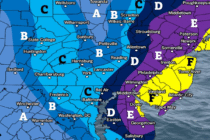
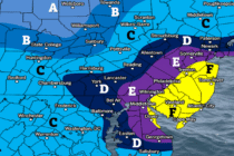
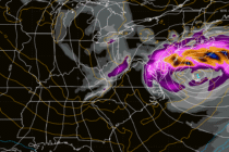
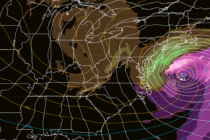
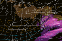
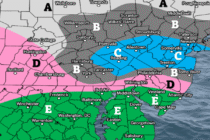
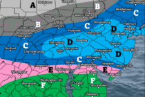
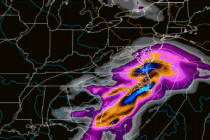
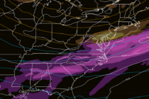
Volatile Changes
Discussion: The upper levels indicate a sharp transition from ridge to trough for the Mid-Atlantic US and much of the E US. At the lower levels we have two areas of high pressure, one over the ocean near Bermuda and
Discussion: Another chilly night tonight (Thursday) as overnight temps fall into the 40s for most of NJ. Coasties closer to 50 and NNJ elevations with the best chance to dip slightly below 40. Our boss cold front came through and
Discussion: Fall is going to finally settle in this week. We have two more days, Monday and Tuesday, where it will be slightly warmer and more humid than most would like to see this time of year. A boss cold
Discussion: I was happy to see the rain hold off today, allowing as much dry daytime hours as possible. As mentioned in the weekend outlook earlier, this is a weak disturbance moving through. The low is currently pushing from NC
Discussion: A cold front pushed through early this morning. Unfortunately, it only reduced temps and humidity a little rather than a lot. We should stay dry for the rest of Friday evening and overnight through much of Saturday. A weak
Discussion: The tropics of the Atlantic Basin are showing signs of life after a relatively quiet 2025 hurricane season so far (for NJ interests). There are currently three systems of interest in the Atlantic Ocean. First is Gabrielle which represents
Discussion: An unsettled period is expected between this Tuesday and Saturday. I know that’s a longer stretch than what we’ve been used to but honestly, we could use the rain. Models are suggesting about 1-2 inches total throughout that period
Discussion: A mostly zonal upper-jet, slightly bucked at times, will flow over the E US for the next 7-10 days. No big troughs or ridges which should keep our region temperate with respect to the time of year. On average,
Discussion: As anticipated last week, we now find ourselves under a strong SE Canadian ridge with a weak upper low meandering from the SEUS up the coast. The upper low will drive another mid-week coastal system (like last week) at
Discussion: The trough pattern, that the Mid-Atlantic and NorthEast US has been in, will take a break by the end of this weekend. This will still allow a nice Friday, Saturday and Sunday start. By Sunday afternoon, the trough will