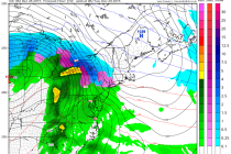
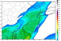
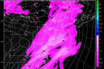
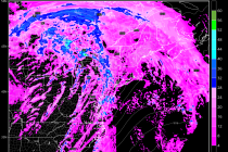
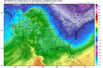
Back to homepage

Latest NJ Weather Alerts

July 15: Improving Conditions Expected

July 15: Improving Conditions Expected

🕔15:41, 15.Jul 2015

What a mess in SENJ this morning! Lots of flash flooding and even a few wind gusts that met severe criteria. The good news is that the surface low pressure system responsible for such is well out to sea and will

Read Full Article
July 14: Monitoring Thunderstorms

July 14: Monitoring Thunderstorms

🕔09:49, 14.Jul 2015

An organized but weak low pressure system will be tracking from the Great Lakes straight over New Jersey between now and tomorrow morning. This system was partly responsible for yesterday’s severe weather that happened further west. It won’t be anything

Read Full Article
July 11: Possible Rough Surf Detected

July 11: Possible Rough Surf Detected

🕔17:22, 11.Jul 2015

A low pressure disturbance should form in the OBX area tomorrow and track NE through Monday—well out to sea and SE of New Jersey. The system could actually pass over warmer gulf stream waters and develop tropical convection. The only

Read Full Article
Gorgeous Weekend Expected! (July 10-12)

Gorgeous Weekend Expected! (July 10-12)

🕔11:02, 10.Jul 2015

It doesn’t get much better than this for a summer weekend! Just one caveat to mention but otherwise, a gorgeous weekend is expected. Let’s break it down: Friday should reach the low-to-mid 80s for high temperatures. Skies should feature plenty

Read Full Article
July 9: Severe Weather Update

July 9: Severe Weather Update

🕔12:19, 9.Jul 2015

Storm energy is already building just south of the Great Lakes and is plotting a course for New Jersey. This update is primarily focused on timing. The possible severity of thunderstorms has not changed. EPA and WNJ are still at

Read Full Article
July 8: Severe Weather Possible Tomorrow!

July 8: Severe Weather Possible Tomorrow!

🕔22:08, 8.Jul 2015

A low pressure disturbance will track from the southern Great Lakes directly over New York City tomorrow. This synoptic system will plunge into an air mass favorable for thunderstorms (some humidity and marginal instability). This will also create a conflict in

Read Full Article
July 8: Thunderstorm Update

July 8: Thunderstorm Update

🕔16:09, 8.Jul 2015

A cold front is moving through PA towards NJ. Ahead of it lies destabilized and unsettled air mass currently responsible for widely scattered showers and thunderstorms. There’s hardly any wind shear so these are mostly instability-driven with tropical surface fuel

Read Full Article
Stormy Week Expected (July 6-10)

Stormy Week Expected (July 6-10)

🕔12:27, 6.Jul 2015

The Bermuda high remains stubbornly positioned for warmer southerly flow all week. This, in addition to several low pressure disturbances passing through from our west should keep it stormy and wet despite a few sunny clearings. Let’s break it down:

Read Full Article
4th of July Fireworks Forecast

4th of July Fireworks Forecast

🕔10:59, 4.Jul 2015

Rain showers currently span from Baltimore, through E. PA and into NWNJ. They will continue to push east in a scattered nature (not widespread) until ultimately fizzling by early evening. Satellite imagery indicates a wall of much drier air moving

Read Full Article
Mostly Decent Weekend Expected (July 2-5)

Mostly Decent Weekend Expected (July 2-5)

🕔16:53, 1.Jul 2015

Most of New Jersey looks pretty good through July 4th weekend except for a few road bumps. There exists just a small chance of clouds and rain on Thursday and Saturday associated with a frontal boundary that will be stationed just to

Read Full Article