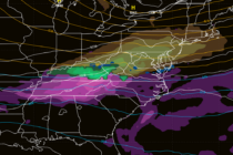
Back to homepage

Latest NJ Weather Alerts

Continuing to look at Fri-Sat Dec 5-6

Continuing to look at Fri-Sat Dec 5-6

🕔15:47, 3.Dec 2025

There’s high confidence that a strong cold front will push through Thursday afternoon/evening. This front will be driven by a piece of polar vortex energy and might as well be called an Arctic front. I think we’re starting to see

Read Full Article
Final Call for Tuesday NWNJ Snow

Final Call for Tuesday NWNJ Snow Updated

🕔16:55, 1.Dec 2025

Discussion: We’ve beat this weak NWNJ snow event to death at this point. This is our final call map heading into it. Live observations will begin late tonight as we look at the precipitation approaching from the W in real-time.

Read Full Article
Tuesday NWNJ Snowstorm a GO

Tuesday NWNJ Snowstorm a GO Updated

🕔16:55, 30.Nov 2025

Discussion: Currently, we have precipitation pushing through ahead of a cold front that is expected to pass through later this evening. The cold front is hooked to a low near Toronto that is pushing eastward into SE Canada/Maine. A warm

Read Full Article
Tuesday Snow Targeting NWNJ

Tuesday Snow Targeting NWNJ

🕔15:39, 29.Nov 2025

Discussion: To touch on the rest of the weekend very briefly, the rest of today/tonight (Saturday PM) looks chilly and dry. Some rain (less than a quarter inch likely) could push through Sunday (late-morning through early evening) ahead of a

Read Full Article
A Few Snow Chances on the Table for Jersey

A Few Snow Chances on the Table for Jersey

🕔15:45, 26.Nov 2025

Discussion: Our current situation (Wednesday afternoon) is very synoptic driven. A ~990mb low is tracking across the Great Lakes. It has dragged a warm front over NJ from S to N putting us in the warm sector for now. That’s

Read Full Article
Thanksgiving Weather Outlook

Thanksgiving Weather Outlook

🕔16:02, 24.Nov 2025

Discussion: We’re now in an expected milder air mass until about Wednesday, with Wednesday likely to peak as the warmest day of the week. We are then going to drop into a colder Thanksgiving Thursday through Sunday morning with another

Read Full Article
Wet Start. Conditions Improve.

Wet Start. Conditions Improve.

🕔15:14, 21.Nov 2025

Discussion: The upper level flow will stay zonal across the E US from now until about Black Friday with a weak ridge flex next Tuesday-Wednesday. That’s when surface temperatures could spike above 60 across parts of New Jersey. A trough

Read Full Article
Cold Start. Wet Transition. Milder Finish

Cold Start. Wet Transition. Milder Finish

🕔15:25, 17.Nov 2025

Discussion: The squirrels are going crazy. The acorn drop this year was aggressive. The weak La Nina ENSO state looks to hold. The -QBO (westerly winds around the equator) look to hold. The MJO is looking like phase 6-7 into

Read Full Article
Mixed Conditions as Fall Begins to Sunset

Mixed Conditions as Fall Begins to Sunset

🕔16:46, 14.Nov 2025

Discussion: 250mb analysis indicates upper NW flow for much of the next 6-7 days outside of a small break this Saturday. 500mb geopotential height analysis reflects this with a small break in the lower height anomalies on Saturday. With that

Read Full Article
Into the Arctic We Go

Into the Arctic We Go

🕔15:53, 10.Nov 2025

Discussion: Nothing has changed with respect to the upper level look this week. If you look at 250mb wind analysis, you’ll see a well-carved trough swinging through the E US with a solid jet streak in the Positive Vorticity Advection

Read Full Article