Back to homepage

Posts From Jonathan Carr

Cold Start to the Week (Nov 13-17)

Cold Start to the Week (Nov 13-17)

🕔20:49, 12.Nov 2017

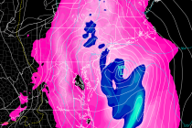
Discussion: Temperatures this week should start below-average and finish near-average heading into the weekend. Overall, upper-level height anomalies are positive through much of the US. The only area of disturbance is currently moving through our region and is expected to

Read Full Article
Cold Conditions Expected (Nov 10-12)

Cold Conditions Expected (Nov 10-12)

🕔20:16, 9.Nov 2017

Discussion: A shallow trough will bring a transient period of well-below average temperatures to the region tonight through Sunday morning. The Arctic shot should peak for New Jersey Saturday AM with moderation expected by Sunday afternoon. Friday and Saturday night

Read Full Article
Colder Transition Expected (Nov 6-10)

Colder Transition Expected (Nov 6-10)

🕔11:52, 6.Nov 2017

Discussion: The upper levels should gradually transition from positive 500mb height anomalies to negative between now and Wednesday. NNJ elevations (mostly NWNJ) has the chance to see their first frozen precipitation of the year Tuesday evening through early Wednesday morning.

Read Full Article
Mild Weather Expected (Nov 3-5)

Mild Weather Expected (Nov 3-5)

🕔09:35, 3.Nov 2017

Discussion: The upper levels look to feature above-average height anomalies. This tells me the overall temperature profile should remain on the milder side for this time of year. Aside from an isolated Friday afternoon shower and raw/damp/misty conditions Sunday, the

Read Full Article
A look through November with WT360

A look through November with WT360

🕔13:36, 2.Nov 2017

It’s time to harness the WeatherTrends360 proprietary weather algorithms to see how November 2017 should play out. But first lets break New Jersey into proper climatological regions. We have the higher elevations of NNJ/NWNJ, the interior coastal plain (SWNJ through CNJ and into NENJ –

Read Full Article
Cooler Start. Mild Finish (Oct 30-Nov 3)

Cooler Start. Mild Finish (Oct 30-Nov 3)

🕔10:31, 30.Oct 2017

Discussion: The storm has retreated northward into Canada after phasing and bringing significant rainfall and moderate winds to portions of New Jersey and especially New England. Behind this system will be a relatively cooler/cold air mass for the first half

Read Full Article
Oct 28: Rainstorm Approaching

Oct 28: Rainstorm Approaching

🕔09:59, 28.Oct 2017

Discussion: Typhoon Lan has moved through the west Pacific Ocean into the Bering Sea. This has produced strong ridging in the Gulf of Alaska/W US area (+PNA) which has symbiotically produced a trough for the E US. The trough is expected

Read Full Article
Great Start. Wet and Windy Finish (Oct 27-29)

Great Start. Wet and Windy Finish (Oct 27-29)

🕔15:48, 26.Oct 2017

Discussion: We have a deep trough swinging through our region between Sunday and Monday, reenforced by strong ridging over the W US/Alaska (+PNA). This jet stream pattern has been affected by the Typhoon that curved into the Bering Sea earlier

Read Full Article
Volatility Continues (Oct 23-27)

Volatility Continues (Oct 23-27)

🕔14:11, 23.Oct 2017

Discussion: A low pressure system is currently tracking into SE Canada over the Great Lakes. A cold front is attached to this system via Norwegian Cyclone Model definition which will pass through between Tuesday and Wednesday morning. Further low pressure

Read Full Article
Gorgeous Fall Conditions (Oct 20-22)

Gorgeous Fall Conditions (Oct 20-22)

🕔21:45, 19.Oct 2017

Discussion: The entire weekend will be dominated by a large area of high pressure. This should keep skies sunny during the day and clear at night. As the high pressure slowly drifts from west to east, winds should transition from

Read Full Article