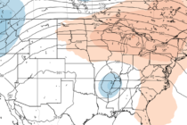
Back to homepage

Posts From Jonathan Carr

Dec 7: First Call Snow Map for Saturday

Dec 7: First Call Snow Map for Saturday

🕔19:05, 7.Dec 2017

Click here to view full resolution snow map! Discussion: The biggest trends I’ve seen over the last few days are timing, strength and NW-precipitation extent. This is now a Saturday event. Flurries could possibly begin late Friday night but the

Read Full Article
Dec 5: Talking Snow

Dec 5: Talking Snow

🕔14:09, 5.Dec 2017

Discussion: Let’s talk about the first frontal passage real quick. Precipitation is likely just ahead and along the cold front this evening into tomorrow morning. I’m expecting most of this precipitation to fall as rain overnight however the last part

Read Full Article
Here Comes Winter (Dec 4-8)

Here Comes Winter (Dec 4-8)

🕔19:36, 3.Dec 2017

Discussion: Monday and the first part of Tuesday should feature milder conditions with SW flow ahead of the cold front. The cold front itself should bring a period of moderate to possibly heavy (at times) rainfall Tuesday PM into Wednesday

Read Full Article
December Discussion with WT360

December Discussion with WT360

🕔17:27, 3.Dec 2017

It’s time to harness the WeatherTrends360 proprietary weather algorithms to see how the rest of December 2017 should play out. But first lets break New Jersey into proper climatological regions. We have the higher elevations of NNJ/NWNJ, the interior coastal plain (SWNJ through CNJ and

Read Full Article
Cool and Calm but Winter is Coming (Dec 1-3)

Cool and Calm but Winter is Coming (Dec 1-3)

🕔19:36, 30.Nov 2017

Discussion: Conditions should be rather uneventful through about Tuesday. Highs in the 40s/50s and lows in the 20s/30s with little to no precipitation. A strong cold front should then move through in the Tuesday night-Wednesday AM period and usher in our first

Read Full Article
Mild Days. Cold Nights (Nov 28-Dec 1)

Mild Days. Cold Nights (Nov 28-Dec 1)

🕔21:53, 27.Nov 2017

Discussion: There’s not much going on in the upper levels through the first part of next week. A few transient colder nights between 2-3 day periods of milder days. The only rain I see this week is late Thursday night/early

Read Full Article
Milder Start. Colder Finish (Nov 24-26)

Milder Start. Colder Finish (Nov 24-26)

🕔19:44, 24.Nov 2017

Discussion: Not much to write home about. SW flow should dominate a milder feel through most of Saturday. Another mostly-dry cold front should then move through heading into Saturday night. Only trace amounts of precip are modeled so some might

Read Full Article
More Volatile Temperature Flops

More Volatile Temperature Flops

🕔21:01, 20.Nov 2017

Discussion: 250mb analysis of the jet stream indicates a general zonal flow across the US for the near future. Tuesday and Wednesday appear rather mild with SW return flow (from the departing high) dominating the pattern. We should then see

Read Full Article
Listen to the wind blow, watch the sun rise

Listen to the wind blow, watch the sun rise

🕔16:19, 18.Nov 2017

Most, if not all, of NJ should see a mild and breezy (out of the SW) start to the night. Some might experience a few early-AM boomers embedded within the short-duration period of heavy rainfall. By the time the sun

Read Full Article
Unsettled Conditions Expected (Nov 17-19)

Unsettled Conditions Expected (Nov 17-19)

🕔21:49, 16.Nov 2017

Discussion: After a colder Thursday night, an area of high pressure should track from the Ohio Valley area through OBX towards Bermuda. This should keep conditions mild and dry through about Saturday morning. We’re then looking at classic Norwegian Cyclone

Read Full Article