Jan 4: AM Winter Storm Update
Discussion: The storm has and is still rapidly intensifying. Current central low pressure is 965mb. While over 300 miles to our E, the center of the storm is still S of our latitude. Over the next 6-9 hours the low


Discussion: The storm has and is still rapidly intensifying. Current central low pressure is 965mb. While over 300 miles to our E, the center of the storm is still S of our latitude. Over the next 6-9 hours the low
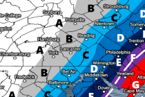
Please click here for full-resolution snow map! Discussion: The surface low that will become the powerful ocean low is in the process of interacting with the upper level energy approaching from the W. It’s all wrapping up as expected into what
Please click here for full-resolution snow map! Discussion: We’re finally transitioning from the mid-range to short-range forecasting period and therefore most major features of this system are locked-in. We know we have phasing energy to our W (will eventually phase

It’s time to harness the WeatherTrends360 proprietary weather algorithms to see how the rest of January 2018 should play out. But first lets break New Jersey into proper climatological regions. We have the higher elevations of NNJ/NWNJ, the interior coastal plain (SWNJ through CNJ
Discussion: After reviewing the latest data and live observations, I’ve noticed a few things. For one the low pressure system’s expected track in the Atlantic Ocean has trended not so much west, but has consolidated on the western side of

Discussion: We’re very cold today through Tuesday as Arctic air reigns dominant. This poses a serious risk of hypothermic medical issues for those braving it outside for either the ball drop or any other outdoor activity surrounding New Years. If you

Discussion: The most impressive remnant of the northern stream energy has moved through S PA and into SNJ this morning. This initial energy is now moving out into the ocean however the weak coastal cyclogenesis has begun near Delmarva. This weak
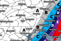
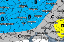
Click here for full-resolution snow map! Discussion: No real changes to last night’s forecast. Snowfall is currently approaching the Ohio Valley region. This should spread through PA and N MD overnight before exiting across NJ tomorrow. Timing is between dusk and
Click here to view full resolution snow map! Discussion: An area of northern stream energy will pass through New Jersey on Saturday from W to E. This energy split off of an incoming wave from the Pacific Ocean near Washington

Discussion: The December 29-30 period has presented a general storm signal for some time now. And that’s all we’ve been advertising due to the complex setup of multiple northern stream shortwaves coming in from and around the Arctic trough…as well

LOCAL FORECAST | INTERACTIVE RADAR | LATEST NJ WEATHER ALERTS | WEDDING FORECAST| PRIVACY POLICY
© Copyright 2024 Weather NJ LLC. All Rights Reserved.
Some information that can be found on our website is provided by a private weather station and is not an officially recognized station for weather reporting. Though we always strive to achieve accurate reporting for our own use, it is important that you do NOT depend on the data provided here for any purpose.


