Not a Washout (April 29-May 3)

Not a Washout (April 29-May 3)

🕔15:56, 29.Apr 2019

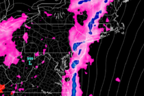
Discussion: I know this outlook is a bit late so we’ll focus on tonight-forward. An upper-level ridge should dominate the region this week with above-average geopotential heights. This should keep the upper-level jet to the N of New Jersey through

Read Full Article
More Mixed Conditions (April 26-28)

More Mixed Conditions (April 26-28)

🕔16:27, 25.Apr 2019

Discussion: Some rain showers are moving across NJ right now (Thursday) and will continue this evening along a warm front. At some point early Friday the warm front will advance to our N and we’ll likely see a period of

Read Full Article
Mixed Conditions (April 22-26)

Mixed Conditions (April 22-26)

🕔21:28, 21.Apr 2019

Discussion: We have upper-level energy consolidating as it fizzles out over the OBX/Delmarva area region Monday. That should be just enough energy to power a small and weak coastal disturbance offshore. It’s really not a big deal but it could

Read Full Article
April 19: Thunderstorms Approaching

April 19: Thunderstorms Approaching

🕔14:22, 19.Apr 2019

Discussion: We continue to evolve towards a two-prong hit of rain and thunderstorms. The first will be pre-frontal activity in the warm sector this evening and the second will be the main expected storm period early Saturday morning. The front

Read Full Article
Unsettled Conditions (April 19-21)

Unsettled Conditions (April 19-21)

🕔21:57, 18.Apr 2019

Discussion: We’re now in the warm sector supported by high pressure near Bermuda and a series of low pressure disturbances tracking just NW of the Appalachian Mountains into Canada. This is why non-coastal areas spiked so warm today and why

Read Full Article
April 17: More Severe Weather Possible

April 17: More Severe Weather Possible

🕔16:19, 17.Apr 2019

Discussion: I’m watching Friday night through Saturday morning for another period of potential severe weather (like this past early-Monday morning). The first player involved is a low pressure system currently cutting way to our NW over the N Great Lakes.

Read Full Article
Mixed Spring Conditions (April 15-19)

Mixed Spring Conditions (April 15-19)

🕔11:16, 15.Apr 2019

Discussion: We’re cooler today (Monday) in the wake of a cold front passage. By mid-week an area of high pressure should set up over the SE US and bring back the warmth via SW return flow. Another frontal passage attached

Read Full Article
April 14: Thunderstorms Approaching

April 14: Thunderstorms Approaching

🕔16:30, 14.Apr 2019

Discussion: A well-organized low pressure system will track through Ohio, NW NY State and ultimately into Maine overnight into tomorrow. We’re in the correlating warm sector today (I don’t need to tell you that) but the cold front should push

Read Full Article
Typical Spring Conditions (April 12-14)

Typical Spring Conditions (April 12-14)

🕔19:05, 11.Apr 2019

Discussion: The main players on the field this weekend are an easterly-departing high and low cutting through the Great Lakes. This configuration should produce mild S flow for most of the weekend. Friday and Saturday daylight hours look pretty good.

Read Full Article
Mild Conditions Expected (April 8-12)

Mild Conditions Expected (April 8-12)

🕔21:14, 7.Apr 2019

Discussion: A warm front will pass through after midnight tonight (Thursday) which should start Monday morning out wet. While not guaranteed don’t be too surprised to wake to a few rumbles during early Monday AM hours. With the warm front

Read Full Article